Forecast for the Uintas Area Mountains

Andrew Nassetta
Issued by Andrew Nassetta on
Sunday morning, March 15, 2026

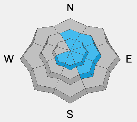
MODERATE avalanche danger exists at and above treeline on wind-drifted, steep, rocky and complex slopes facing northwest through east where large, human-triggered, hard-slab avalanches are POSSIBLE. Although we are seeing fewer red flags, recent avalanches failing into faceted and snow breaking hundreds of feet wide remind us that it's still game on in the high country.

It's tricky out there, please don't let the danger rose fool you -- Even though the likelihood of triggering a large slide as a rider is decreasing the potential consequences remain severe if we do.

Low
Moderate
Considerable
High
Extreme
Learn how to read the forecast here
Special Announcements

Each spring, we ask for your continued financial support to fund our forecasting programs. We hope you will consider supporting our mission by checking out our campaign and auction, live and available.

Weather and Snow

Nowcast - A cold spring morning kicks off with trailhead temperatures dipping into the teens °F whilst upper elevation stations report temperatures in the single digits. We scraped up a little snow overnight with 1-3" at our highest elevations near the Mirror Lake Corridor and Central Mountains, and closer to 1" in peripheral terrain. The real story is the winds blasting along the high peaks overnight in the strong category, averaging 40-50 MPH, and gusting into the 60's and 70's.

Forecast -Expect more of the same throughout the day with strong winds from the northwest gusting into the extreme category, up to 70 MPH along the high, exposed ridges. Skies are partially covered, and look to open up more as the day rolls into the afternoon.

Futurecast - We stay cool through tomorrow, but historically warm weather enters the region on its heels. Our snowpack will surely take a hit and we will keep you in the loop with what that looks like over the coming days.

Travel Conditions - The change of seasons officially starts when the blacktop appears and our typical staging areas are no more. North and south side gates are open on HW150, plowed from the north to Whitney and from the south to Spring Canyon, and of course SR35 remains open over the pass. Although its grim from down low and riding is spotty and hard to find, soft snow is out there for the taking, Solars are melted out up to 9,000' and many windward slopes are scoured and worked to the dirt. But te best riding exists above 10,500' at and above treeline, in protected and sheltered areas where the snow has not been hammered by the elements -- With a little work and some knowing where your going you will find it!
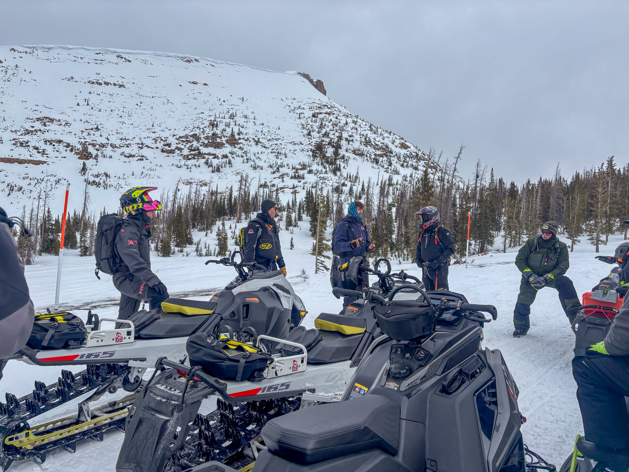
A weathery Saturday provided us with an opportunity to get out for a Ride & Refresh with a crew of local rippers from the region. Thanks to UAC Staff McKinley & Chad, and Forecaster Nikki Champion for putting together a valuable day -- If you and your riding crew want to get out with us for some riding and educational refreshing, reach out to us!
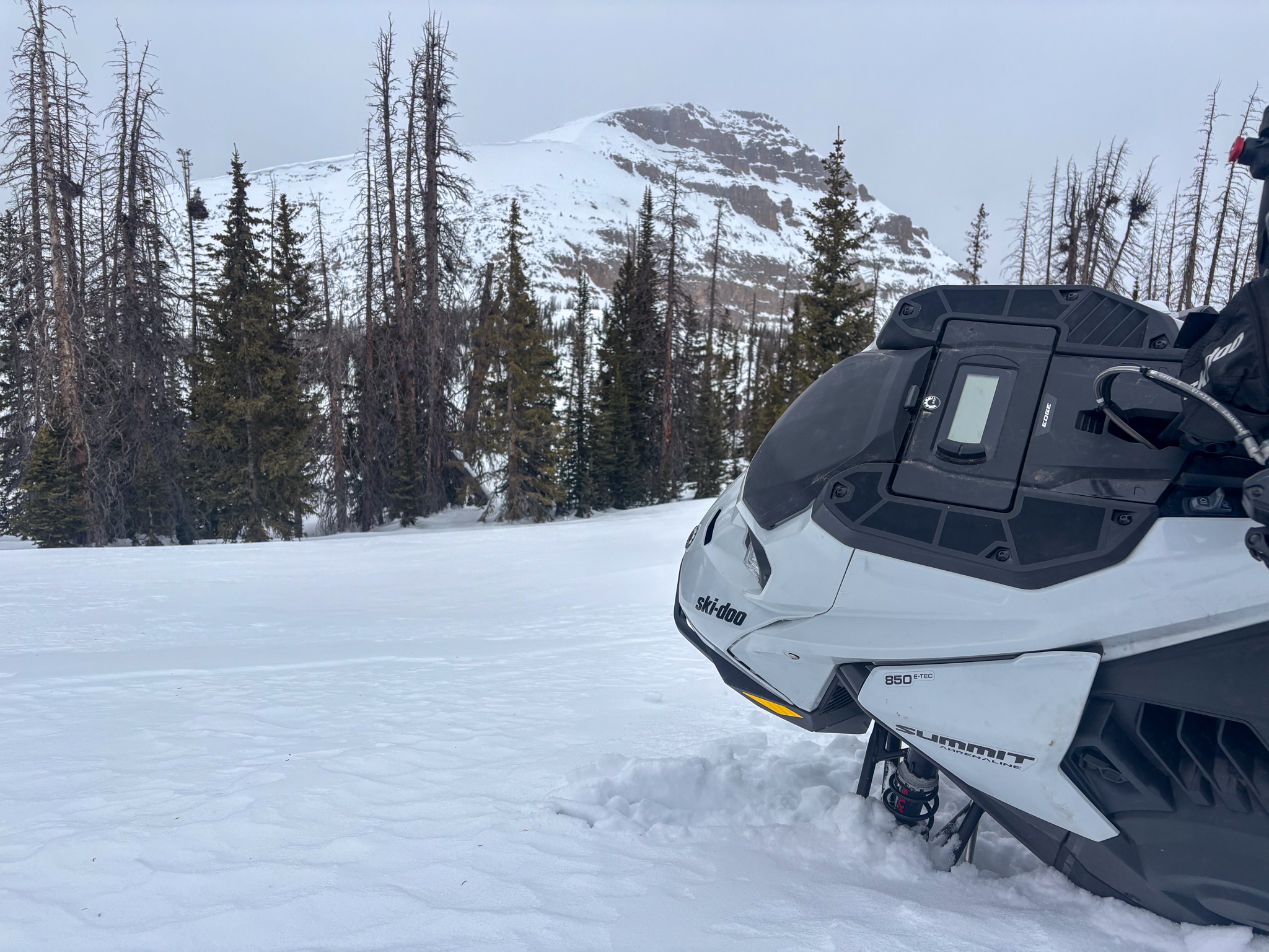
It is becoming hard to find and harder to get to, but don't let that steal your thunder. Up high there is still soft snow above 10,500' providing some super surfy, predictable, and adventurous riding conditions.

Recent Avalanches

Yesterday, our good friend and overall stellar fella Chris Brown was traveling around the Central Uinta's and shared some great intel from his travels, as well as a few reports of natural avalanches that failing during periods of strong winds this past week. Check out more from his travels, here.
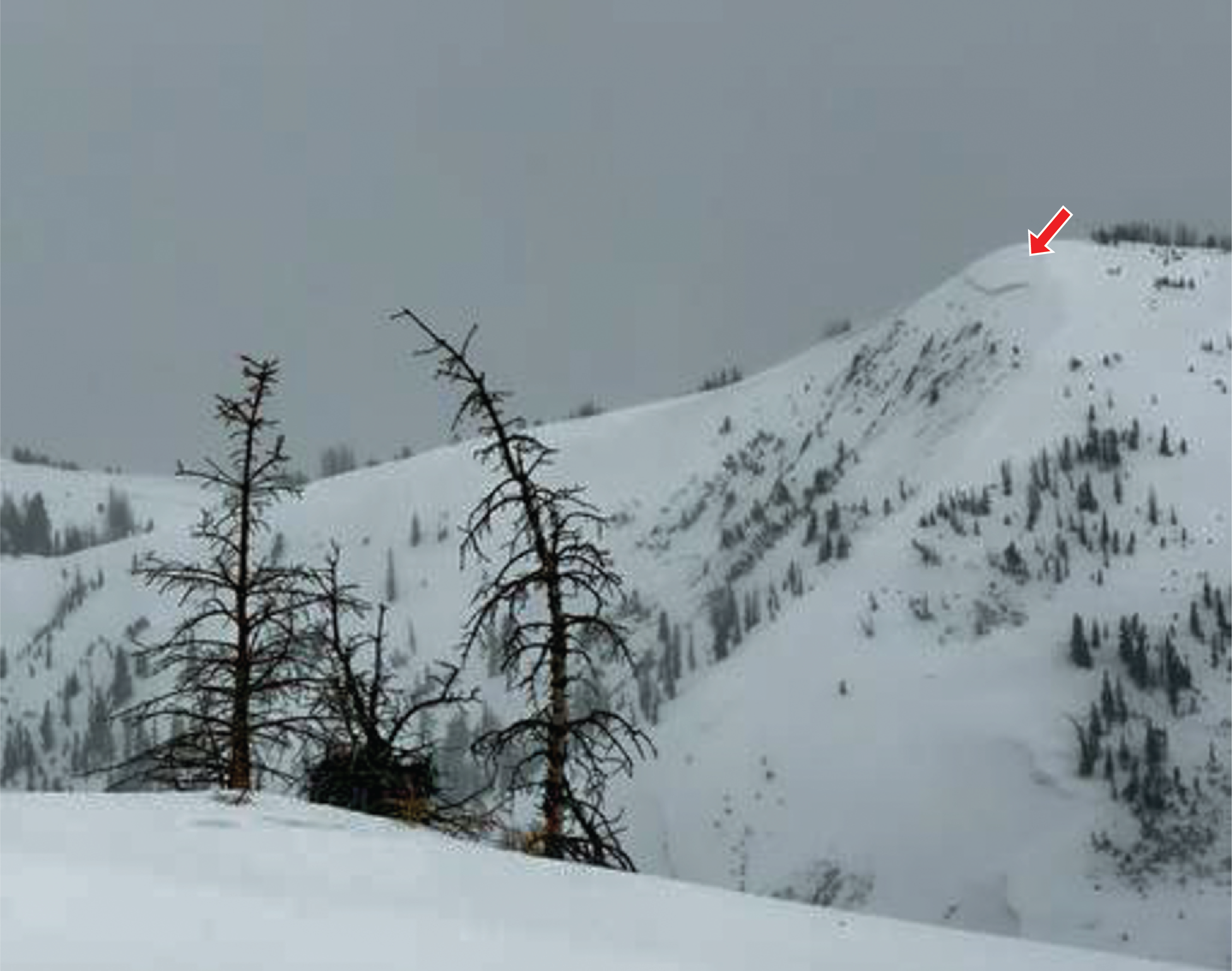
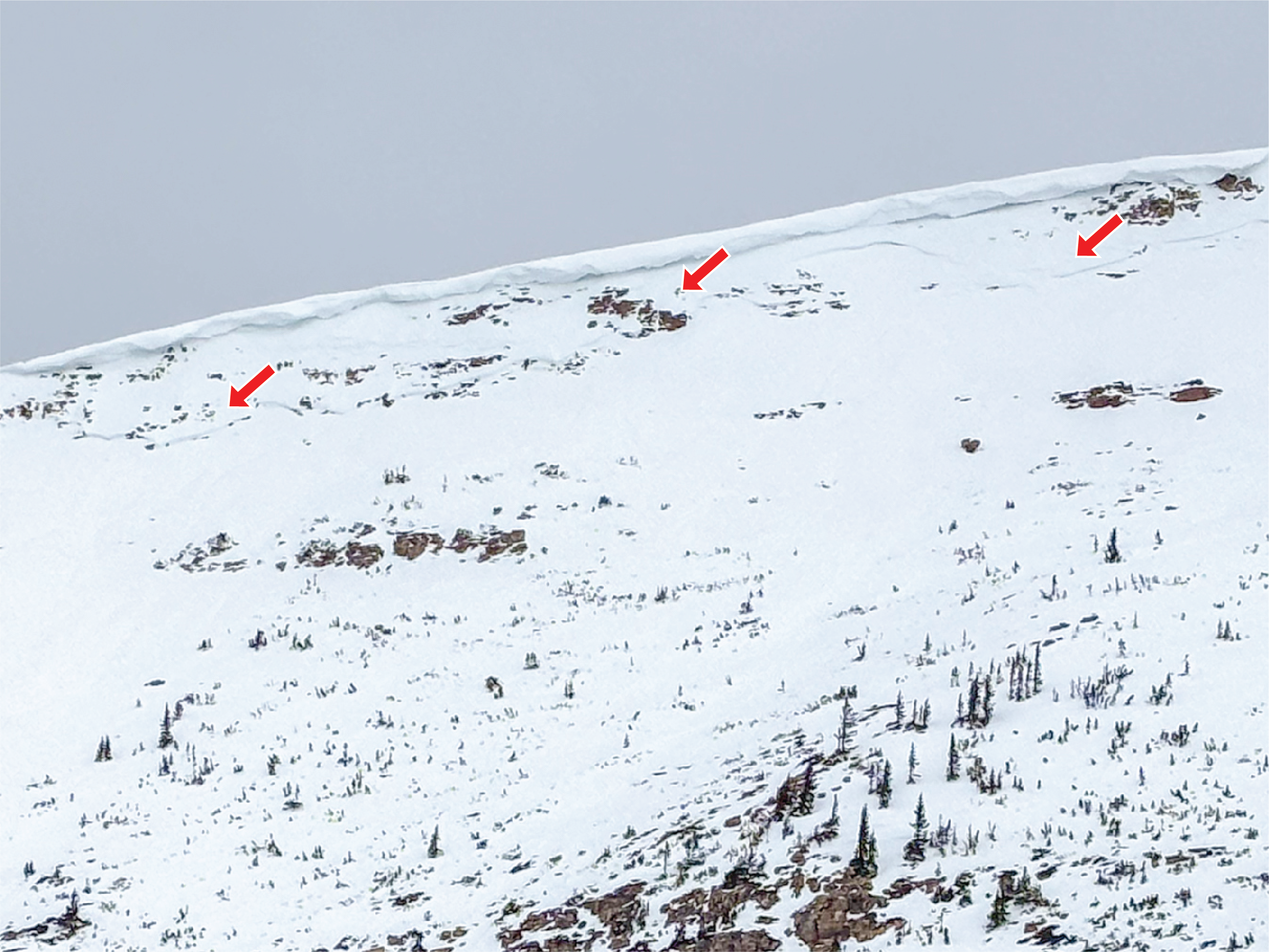
At 11k' near Deadman's Peak on a north facing slope, a well connected persistent slab avalanche failed this past week during a period of extreme westerly winds up to 2' deep and nearly a 1,000' wide (via Chris Brown). See more, here.

Avalanche Problem #1
Persistent Weak Layer
Type
Location
Likelihood
Size
Description

In Mill Creek, another persistent slab looking fresher than the rest was observed by Chris B. We're thinking it failed late this week during another spike in winds running nearly 1,000' and stacking up a decent debris pile in the run out -- Check out his ob, here!

It's straight up tricky out there, here's the set-up -- Weak, sugary facets that formed during January are now protected under a dense, cohesive slab between 1 and 4' deep. It’s strong snow over weak snow and that’s a dangerous combo. The challenge is that the obvious clues to instability may be seen and we can trench multiple sets of tracks on a slope without triggering an avalanche. But all we need to do is find a weakness where the slab and weak layer are susceptible to our additional weight as a rider, maybe around a rock outcropping or tree, collapse the pack, and trigger the avalanche.

This problem isn’t everywhere, but when you find it, it’s unpredictable and hard to manage. Complex slopes that are steep, rocky, and shallow on the north half of the compass are still off the terrain table. I can not outsmart this problem, so avoidance is my go-to tool for this dragon.

Above, on a north facing, wind-drifted slope near 11,000' with about 145cm of snow, you can see a cohesive slab sitting over our weak, continental facets where our recent human-triggered and natural avalanche are failing.

Avalanche Problem #2
Wind Drifted Snow
Type
Location
Likelihood
Size
Description

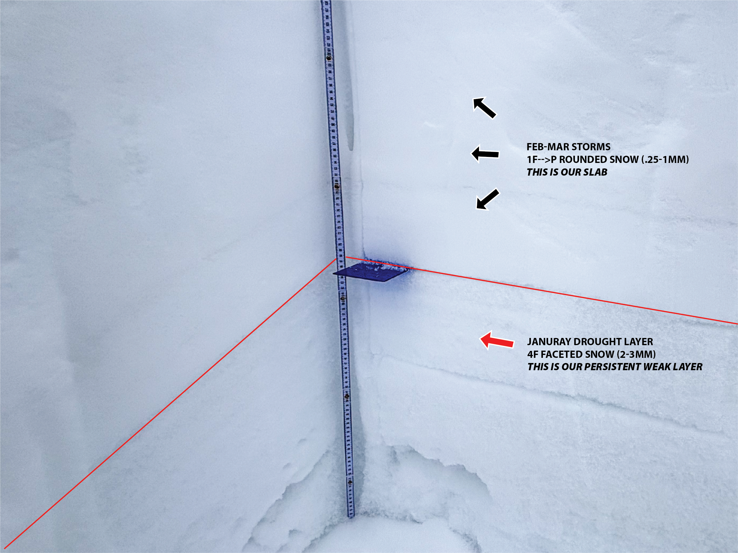
A hard wind-slab on Bald Mountain that failed naturally on a south facing slope at 11,500' in the windzone, breaking 1-2' deep and nearly 500' wide.

Over the past week winds blowing from the west have continued transporting snow forming slabs of wind-drifted snow. Up to 2' deep, watch for todays drifts on leeward slopes around terrain features like gullies, rock outcroppings, sub-ridges, and mid-slope rollovers. These drifts will look smooth and rounded, feeling supportable under our rigs, allowing us to get well out on the slope before they fail.

Remember that any avalanche triggered into wind-drifted snow has the potential to step-down into buried weak layers in the snowpack, creating a much larger avalanche than expected.

General Announcements

We are always looking for snow and avalanche observations or just general riding conditions. Reach out to us with questions, concerns, or if you see anything in your travels! Contact us directly through the info below:

Craig Gordon | [email protected] | 801 231 2170

This forecast is from the U.S.D.A. Forest Service, which is solely responsible for its content. This forecast describes general avalanche conditions, and local variations always occur. This forecast was issued on Sunday, March 15, at 6:00 AM and expires 24 hours after it was issued. We'll update this information by about 7:00 AM tomorrow.