Forecast for the Uintas Area Mountains

Andrew Nassetta
Issued by Andrew Nassetta on
Sunday morning, January 11, 2026

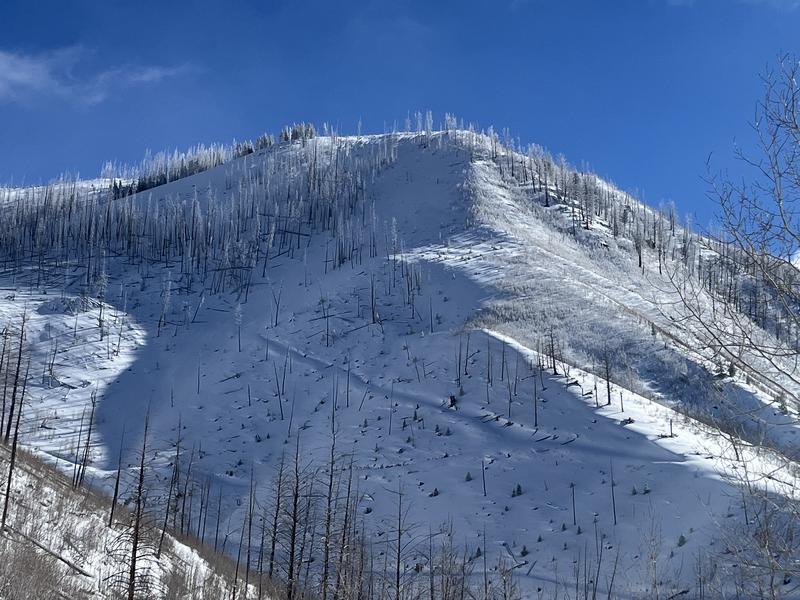
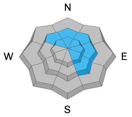
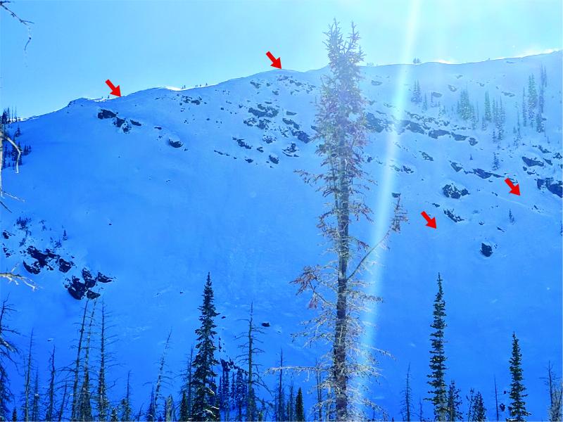
In upper elevation terrain on slopes northwest through east, the avalanche danger is CONSIDERABLE and human triggered, wind-drifted avalanches are LIKELY. Once triggered, today's drifts could step down and fail into persistent weak layers near the ground, breaking 2-5' deep, up to a football field wide, and taking out the entire season's snowpack with it.

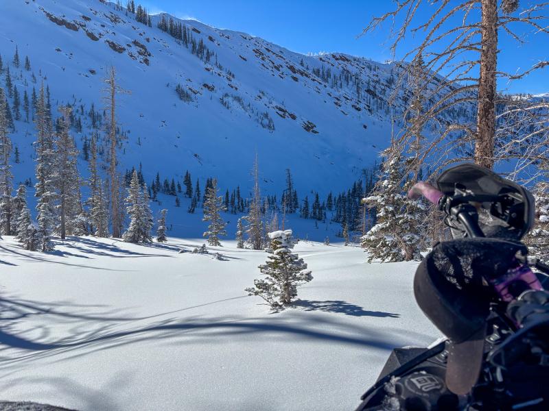
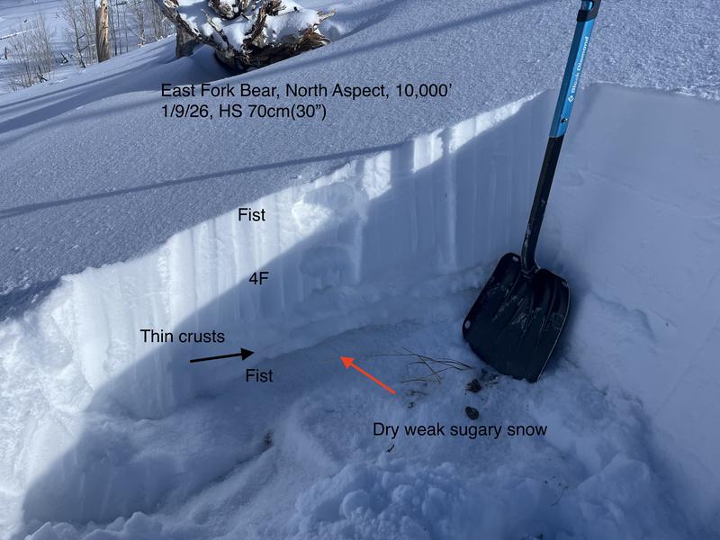
I am avoiding avalanche terrain on the north half of the compass that harbors faceted, weak snow where I am able to still trigger a large avalanche. Instead, my rig and I are pointed towards sunny slopes, where the snow is still cold, the riding is 5-star, and there is less danger of avalanches.

Low
Moderate
Considerable
High
Extreme
Learn how to read the forecast here
Weather and Snow

Nowcast - Another beautiful, crispy, Uinta morning with temperatures inverted and upper elevation stations reading in the 20's °F while lower elevation trailheads hover in the single digits. Winds blow from the northeast, averaging 15 MPH while gusting into the mid-20's along the high ridgelines, but have backed off since 0400 AM and are now calm.

Forecast -Although chilly, today will be slightly warmer than the past few days with temperatures climbing into the high 20's during the heat of the day. Easterly winds continue to blow and will shift to the south later this morning into the afternoon, while speeds remain tame and light.

Futurecast - Sunny skies persist through the week, with a look for a snow shower or two as the weekend draws near.

Travel Conditions - Riding and skiing across the range has been 5-star lately with a supportable, go anywhere base. It's still thin at lower elevations, about 1-2', but the Christmas Eve raincrust keeps us off the ground at mid and upper elevations where depths are 3-5', and recent storms have helped to cover up lingering rocks, stumps, and other terrestrial hazards. All aspects have been riding well, and I suspect another cold night kept the snow surface cool and crust-free on the solars, while the polars continue to be deep and blower.

From how good the riding has been lately, you wouldn't even think twice about the rough start the winter has had. It feels good to finally put the rig up on edge with confidence as snow depths have finally reached a level to cover up most hazards beneath our rides.

Ted was in the East Fork of the Bear River and noted a thinner and generally weaker snowpack structure. More intel and insight from his travels can be found, here.

Recent Avalanches

A few minor wind slabs were reported from the range yesterday , failing in steep, rocky, upper-elevation terrain.

Dan G and Co. were out in the Mirror Lake Corridor and noted old persistent slab avalanches from last week with new, fresh wind-slab debris overrunning them. You can find more information on this avalanche here.

Avalanche Problem #1
Persistent Weak Layer
Type
Location
Likelihood
Size
Description

Thin, shallow, steep, and rocky -- Slopes like the one above are suspect, and the red arrows indicate places the snowpack is most susceptible, and where we are most likely to trigger an avalanche as a rider.

The likelihood of triggering a persistent slab avalanche is going down, but it is still possible as a rider to trigger a slide breaking 2-5' deep, hundreds of feet wide, that takes out the entire season's snowpack. Recent storms added more depth than weight to our snowpack, and although we stacked up 2-3' of snow over the past two weeks, it only totaled to about 1.75" of SWE. This additional load did not make the snowpack hyper-sensitive, and recent avalanches failing deep and breaking wide have required big triggers like a cornice, or smaller avalanches to step-down.

Suspect terrain is steep, rocky, wind-affected slopes facing northwest through east that have a shallower snowpack (<3'). It is a bit like Minesweeper out there -- Although the likelihood of us triggering a large avalanche has gone down, if we play the game enough and keep putting tracks in terrain where this avalanche problem exists, we are bound to hit the mine eventually. How do we lose the game? All we need to do is find a thin portion of the snowpack around a rock or bush, collapse the weak layer (whumpf), and now we're staring down the barrel of a dangerous avalanche. Remember, today's avalanches are tricky, unmanageable slides. Instead of trying to outsmart the avalanche, avoidance is my go-to tool, and I will steer clear of this problem until it goes away.

Ted was taking a look at things around 10,000' near the East Fork where he found a shallow, weak snowpack less than 3' that has a similar structure to that of deeper parts of the range.

Avalanche Problem #2
Wind Drifted Snow
Type
Location
Likelihood
Size
Description

Near Anchor Peak, the red arrows above show recent wind slabs breaking near rocks and ridges. I would expect to find fresh drifts on similar, specific terrain features today.

For the past 24 hours, winds blowing from the northeast in conjunction with our recent, light-density, storm snow have created sensitive drifts up to 2' deep in upper elevations that will be reactive to the additional weight of a rider. I am dealing with this avalanche problem by looking for and avoiding fat, rounded pillows of snow, especially on the leeward side of ridges, chutes, gully walls, and cut banks. Today's drifts can be hard or soft, and we may not trigger them until we are well out onto the slope already. Also, keep an eye out for sensitive cornices, as they go hand in hand with today's wind slabs. Remember, these small wind drifts can step down and fail into deeper weak layers within the snowpack, triggering a larger slide than we originally expected.

A small, fresh, wind-slab that pulled out under a rock band on Notch Mountain and most likely failed during periods of strong winds yesterday.

General Announcements

We have some upcoming classes and events that we'd be stoked to see you at -- Please reach out with any questions and check out below for more details!

We are always looking for snow and avalanche observations or just general riding conditions. Reach out to us with questions, concerns, or if you see anything in your travels! Contact us directly through the info below:

This forecast is from the U.S.D.A. Forest Service, which is solely responsible for its content. This forecast describes general avalanche conditions, and local variations always occur. This forecast was issued on Sunday, January 11th at 0500 AM and expires 24 hours after it was issued. We'll update this information by 07:00 AM tomorrow.