Forecast for the Uintas Area Mountains

Craig Gordon
Issued by Craig Gordon on
Saturday morning, January 10, 2026

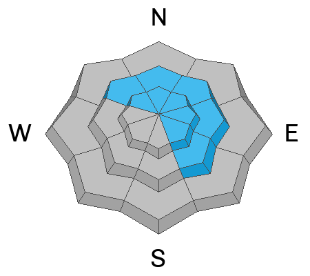
Making up a small portion of the terrain available to ride today, at and above treeline, you'll find pockets of CONSIDERABLE avalanche danger and human triggered avalanches are LIKELY on steep, upper elevation slopes, especially those above treeline, facing the north half of the compass. Getting harder to trigger, yet still breaking 3-5 feet deep, failing into old snow, and shattering up to a football field wide, these are not to be messed around with avalanche dragons. Steep, rocky slopes, with a shallow, weak snowpack are primetime suspects.

In addition, fresh drifts, reactive to our additional weight continued forming overnight on the leeward side of mid and upper elevation ridges where MODERATE avalanche danger is found. Easy to detect and easy to avoid, human triggered avalanches are POSSIBLE on steep slopes with recent deposits of wind drifted snow.

Here's my exit strategy... the solars are firing and I'm gonna avoid avalanche terrain altogether and work on my winter tan by steering my program towards high quality riding on low angle, sunny slopes, with no overhead hazard. Done, done, and done :)

Low
Moderate
Considerable
High
Extreme
Learn how to read the forecast here
Weather and Snow

Nowcast - With clear skies overhead, temperatures hover in the single digits F from tip to tail. Winds blow in the mid 20's mph from the north with a hint of northeast occasionally creeping into the mix. On a go-anywhere base, riding and turning conditions are outstanding.

Forecast - A stunning day is on tap with mostly sunny skies, diminishing winds, and temperatures climbing into the mid and upper 20's F. Overnight lows dip into the teens F.

Futurecast - High pressure homesteads over the region through most of the upcoming week delivering sunny skies and warming temperatures. There's a hint of scattered snow showers to wrap up the workweek.

Travel Conditions - Since the turn of the New Year, travel conditions have dramatically improved across the range with supportable snow depths registering from 3-5 feet. It's still a little lean at lower elevations, but the Christmas Eve raincrust keeps us off the ground and last weekends dense storm snow helps put to bed any lingering rocks, stumps, lumps or bumps.

Our Windy Peak weather station is in a rugged location, was literally frozen in time, and needed a little love. I visited Ice Station Zebra yesterday... above are images before and after a very successful Microderm abrasion treatment. Looking rather handsome huh? *Results based on clinical studies, you're own experience may vary :)

Recent Avalanches

A small pocket triggered by a snowboarder on the leeward side of a ridgeline while he descended a steep, northeast facing slope in the Wolf Creek area yesterday.

More trip reports and additional avalanche observations are just a click away on the button below.

Avalanche Problem #1
Persistent Weak Layer
Type
Location
Likelihood
Size
Description

Trevor captured this image of a large natural avalanche in Upper Chalk Creek. It most likely occurred early in the week, during the height of the storm, but mirrors exactly the kind of snow structure and terrain where we could still trigger a deep, scary avalanche today.

Our snowpack is becoming deeper and more resilient over time, and this weeks low density snow and minimal water weight is hardly enough for our pack to take notice. However, there's plenty of slopes throughout the range that are still adjusting to the big storm from last weekend and will come to life with a little provocation. And while it's becoming more the exception than the rule, I suspect the usual suspects like steep, rocky slopes with a shallow, weak snowpack, could react to our additional weight. Sure, we might forget about deeply buried weak layers, but the snowpack has an amazing memory. Don't forget, all we need to do is find a thin portion of the snowpack, like around a rock or bush, collapse the weak layer (whumpf), and now we're staring down the barrel of a dangerous avalanche.

Since we don't have avalanche goggles (patent pending :) and can't see where these landmines exist, I'm moving with caution and intent by slowing down, gathering facts, and reminding myself... even though we're into January, our snowpack is in it's infancy and barely comfortable in its own skin. I also know persistent slabs are tricky, unmanageable avalanche dragons, and instead of trying to outsmart the snowpack, I'm gonna use avalanche avoidance and terrain management as my go-to tools.

Avalanche Problem #2
Wind Drifted Snow
Type
Location
Likelihood
Size
Description

Data dump for Windy Peak (10,662') illustrating winds at work along the high peaks.

There's enough low density storm snow available to blow around and team up with ridgetop winds, and that combo easily whips up a fresh round of drifts reactive to our additional weight. This avalanche dragon is straight-forward and I'm looking for and avoiding fat, rounded pillows of snow, especially on the leeward side of ridges, chutes, gully walls, and cut banks. In addition, I'm gonna steer clear of hard, dense drifts, especially if they sound hollow like a drum.

Additional Information

There is no better time to take any avalanche course than now! Whether you sled, ski, board or snow angel, we have a class for you. Reach out to us to get into an avalanche course that fits you best, or get your riding crew together and lets set-up a private day on snow!

General Announcements

We have some upcoming classes and events that we'd be stoked to see you at -- Please reach out with any questions and check out below for more details!

We are always looking for snow and avalanche observations or just general riding conditions. Reach out to us with questions, concerns, or if you see anything in your travels! Contact us directly through the info below:

This forecast is from the U.S.D.A. Forest Service, which is solely responsible for its content. This forecast describes general avalanche conditions, and local variations always occur. This forecast was issued on Saturday, January 10th at 0400 AM and expires 24 hours after it was issued. We'll update this information by 07:00 AM tomorrow.