Forecast for the Ogden Area Mountains

Drew Hardesty
Issued by Drew Hardesty on
Wednesday morning, March 25, 2026

The avalanche danger will quickly rise to CONSIDERABLE with direct sun and daytime heating for both wet-loose and large wet slab avalanches. Avoid being on or underneath steep slopes once the snow surface becomes loose and unconsolidated.

In our lifetimes, these are unprecedented conditions. No one has seen these conditions before.

(Gray on the danger rose indicates little to no snow.)

Low
Moderate
Considerable
High
Extreme
Learn how to read the forecast here
Special Announcements

A new version the UAC's mobile app has been released with many new features and performance improvements. Download our app today, available on iPhone and Android. Learn more HERE.

Weather and Snow

Skies are clear.

Overnight "low" temperatures are in the upper-40s to the mid-50s...roughly 6-8 degrees warmer than this time (5AM) 24 hours ago. Winds are from the west, blowing 15-20mph with gusts to 25.

For today, we'll see mostly sunny skies, light to moderate winds from the southwest, and daytime highs reaching to the mid-50s F up high and - I can't believe I'm writing this in late March - the mid-60s°F down low. The Ogden valley is expected to see temps in the low-80s. Riding conditions are best described as loose, unconsolidated gloppy mank. Some have described it as like the 7-11 Slurpee, but that conjures up too many good thoughts, too many good memories. And that's not what it is. It should be noted that many ski areas have closed off terrain because of the hazardous riding conditions; which speaks nothing to the avalanche conditions, which are - in a word - considerable. So from a risk-reward calculus, it truly is a high risk-low reward payoff. It might be best to wait until next week when - possibly - a more active and snowy pattern arrives.

A weak and mostly dry cold front arrives tonight that may be accompanied by light showers, but my bet is on virga. Virga, you'll recall, is when precipitation falls but never hits the ground.

Recent Avalanches

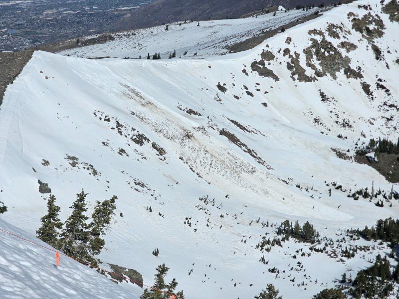
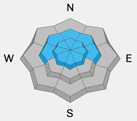
Avalanche control teams noted a new large natural wet slab avalanche in upper Jacobs Creek area along the Ogden skyline south of the Weber River. It was on a steep easterly facing aspect near 9000'...and may have been triggered by natural cornice fall. photo below

Avalanche Problem #1
Wet Snow
Type
Location
Likelihood
Size
Description

There are two concerns for wet snow avalanches:

1. Wet Loose - This will be the most common concern, with the possibility for natural and human-triggered avalanches involving wet snow near the surface. These may be long-running and gouge down into the snow pack. These avalanches are especially dangerous in steep terrain or above terrain traps such as steep-sided gullies where escaping the flow is difficult.

2. Wet Slabs - As meltwater moves deeper into the snowpack, it can pool on buried crusts or weak layers, weakening the structure and allowing avalanches to break deeper and wider. These are larger and more destructive avalanches and may occur naturally, possibly failing down around crusts that formed over the holidays in late December.

Although not a common concern in the Ogden mountains, glide avalanches occur when the entire snowpack slowly slides on the ground, typically over smooth rock slabs or grassy slopes. The terrain around the Chilly Peak Slabs is the most common area for glide avalanches. I've also seen glides in the Willard Creek/Willard Mountain terrain north of Willard Peak.

General Announcements

This information does not apply to developed ski areas or highways where avalanche control is normally done. This forecast is from the U.S.D.A. Forest Service, which is solely responsible for its content. This forecast describes general avalanche conditions and local variations always occur.