Forecast for the Moab Area Mountains

Eric Trenbeath
Issued by Eric Trenbeath on
Friday morning, March 6, 2026

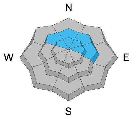
The avalanche danger is MODERATE on steep slopes near and above treeline facing NW–N–NE–E. In these areas, hard slab, human-triggered avalanches 2–4 feet deep failing on a buried persistent weak layer remain POSSIBLE. If released, they could step down and involve the entire season’s snowpack.

The decrease in danger should not be mistaken for safe conditions, but rather a reflection of the overall likelihood for triggering an avalanche. The odds have decreased, but the consequences remain the same. Personally, I'll be continuing to avoid steep, northerly aspects near and above treeline.

New snow today should not increase the avalanche danger but be alert to changing conditions. If we get more snow than expected, be on the lookout for shallow slabs of wind drifted snow forming on leeward sides of ridge crests and terrain features in exposed terrain.

Low
Moderate
Considerable
High
Extreme
Learn how to read the forecast here
Special Announcements

Geyser Pass Road Conditions: The road is plowed and scraped down to the dirt in most areas.

Grooming: Conditions are pretty rough and we need more snow to groom again.

Mountain Film on Tour returns to Star Hall in Moab on Saturday, March 14. Tickets are available online and all proceeds benefit UAC Moab. Look forward to seeing you all there!

All accident reports are completed from the deadly week in northern Utah. Our sincerest condolences to all of those affected.

Weather and Snow

24 Hour Snow: 1" 72 Hour Snow: 1" Season Total Snow: 72" Depth at Gold Basin: 32"

Winds on Pre-Laurel Peak: NW 10-15 Temp: 17°F

Weather

Light snow is falling this morning and should continue through the day with 2-4 inches possible. Temperatures will remain cold with highs in the low 20's. Blustery winds will blow out of the northwest. Lows tonight will drop into the low teens with continued breezy conditions as winds shift to the northeast. Saturday will be sunny and cool with high temps around 30°F at 10,000 feet. A dry, warming trend is on tap for next week.

General Conditions

We'll take what we can get but I don't expect too much of an improvement from today's snowfall, nor do I anticipate much of a change in avalanche danger. But as always, be alert to changing conditions and expect the danger to rise if we get more snow than anticipated. The prolonged heat and lack of precipitation have taken a toll on the snowpack and all surfaces are crusted over to varying degrees. Dust on crust will be the name of the game today.

Dry, faceted weak layers remain widespread on northwest through east aspects and continue to pose a serious concern. The greatest risk exists near and above treeline, where hard slabs overlie weak facets. This is a notoriously unpredictable setup that offers little to no warning before failing. It’s a familiar pattern for seasoned La Sal skiers and riders, and the safest approach remains the same: avoid steep terrain on the north half of the compass.

I shot this video last Sunday while we were still at considerable danger. We have since moved into moderate but there are some salient points to take home.

See all Moab observations here.

Snowpack and Weather Data

Wind Station on Pre-Laurel Peak (11,400')
NWS forecast for the La Sal Mountains.
Recent Avalanches
No recent avalanches have been observed. The avalanche database has been updated to include all observed avalanches from the last cycle. These are all great examples of the type of avalanche that are possible to trigger.
Avalanche Problem #1
Persistent Weak Layer
Type
Location
Likelihood
Size
Description

It’s been two weeks since the last storm and avalanche cycle. Buried persistent weak layers are slowly adjusting to the load and are becoming more stubborn to trigger. Obvious red flags like collapsing and cracking have faded, but the underlying snowpack structure remains poor. The danger has dropped to moderate, but the consequences of triggering an avalanche remain severe.

On northerly aspects near and above treeline, thick hard slabs—2 to 4 feet deep—rest on top of these persistent weak layers. This is a highly unpredictable setup, and committing to steep slopes with this structure is a gamble. If triggered, avalanches could step down and take out the entire season’s snowpack.

Thin, rocky areas, steep convex rollovers, and slab margins remain likely trigger points. When the payoff for riding steep terrain is minimal, it’s hard to justify the risk. My approach continues to be simple: avoid steep slopes in this terrain altogether.

Additional Information
General Announcements
This forecast is from the U.S.D.A. Forest Service, which is solely responsible for its content. This forecast describes general avalanche conditions and local variations always occur.