Forecast for the Moab Area Mountains

Eric Trenbeath
Issued by Eric Trenbeath on
Sunday morning, February 22, 2026

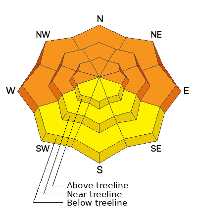
The avalanche danger is CONSIDERABLE on all steep slopes facing west through north through east and human triggered avalanches are likely. The danger increases with elevation where strong winds have built thick hard slabs over top of buried persistent weak layers. The bullseye zone is on slopes at and above treeline that face N-NE-E. In these areas, deep and dangerous, human triggered avalanches 2-4 feet deep are likely. Avoid all steep slopes facing the north half of the compass today.

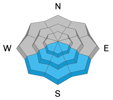
We may see a MODERATE avalanche danger develop on steep sun exposed slopes as the day heats up. Loose, dry powder snow is at its most vulnerable and reactive state as it heats up for the first time. Signs of instability include roller balls, pinwheels, and sloppy wet snow. Stay off of and out from under steep slopes if these signs are present.

Low
Moderate
Considerable
High
Extreme
Learn how to read the forecast here
Special Avalanche Bulletin

Warning Times:
Sunday, February 22, 2026 6:00 AM MST – Monday, February 23, 2026 at 6:00 AM MST

What:
The Utah Avalanche Center is warning of dangerous avalanche conditions across all Utah mountains this weekend. This week’s heavy snowfall and strong winds overloaded preexisting weak layers, creating a HIGH avalanche danger across the entire state. With improving weather moving in for the weekend, avalanche accidents are likely in the backcountry. There have already been two tragic avalanche fatalities this week, as well as several close calls and numerous backcountry avalanches reported.

Where:
The mountains of Utah and southeastern Idaho.

Impacts:
Dangerous avalanche conditions exist in the backcountry and will persist through the weekend. Natural avalanches are possible, and people are likely to trigger avalanches on slopes steeper than 30 degrees. Dangerous and deadly avalanches can be triggered remotely (from a distance or from below). People leaving ski area boundaries are entering the backcountry where the same dangerous avalanche conditions exist.

Special Announcements

Geyser Pass Road Conditions: The road is plowed and scraped down to the dirt in most areas.

Grooming: LUNA started grooming trails yesterday by packing into Gold Basin.

Mountain Film on Tour returns to Star Hall in Moab on Saturday, March 14. Tickets are available online and all proceeds benefit UAC Moab. Look forward to seeing you all there!

Weather and Snow

24 Hour Snow: 0" 72 Hour Snow: 14" Season Total Snow: 71" Depth at Gold Basin: 43"

Winds on Pre-Laurel Peak: S 15-25 G 31 Temp: 16°F

Weather

A beautiful sunny day is on tap as high pressure builds over the region. Daytime high temperatures will be 5-10 degrees warmer than yesterday rising up into the low 30's at 10,000 feet. We've seen a bump in southerly winds this morning but they should back off and be mostly light and westerly today. A warming trend is ahead with steadily increasing temperatures throughout the coming week. On Wednesday, a storm system will affect primarily areas to the north and east of us.

General Conditions

Look for another bluebird powder day after Friday's storm delivered 14 inches of the light fluffy stuff. This brings totals for the week up to 22 inches. The recent snow has begun to settle but excellent turning and riding exists most everywhere, just stay off of, and out from under slopes steeper than 30 degrees. Sunny slopes were still dry yesterday but they will take on some heat today and this is when they will be the most reactive. Avoid steep, sun exposed slopes if they show signs of getting wet - rollerballs and pinwheels are early indicators.

Conditions were perfect for our Backcountry 101 class yesterday with plenty of red flag signs of instability including cracking, collapsing, poor snowpack structure, and reactive stability tests, even at low elevation. Read our observation here. We also received numerous other reports of collapsing up high as well as recent large natural avalanches. Read this observation from Sam Van Wetter.

See all Moab observations here.

Snowpack and Weather Data

SNOTEL site near Geyser Pass Winter Trailhead (9600')
Wind Station on Pre-Laurel Peak (11,400')
NWS forecast for the La Sal Mountains.
Recent Avalanches
Sam Van Wetter sent in this pic of a large natural avalanche that ran in Red Snow Cirque, likely during the height of the storm on Friday. And on Thursday, Dave and I were stomping around on Laurel Ridge and he was able to intentionally trigger this large, hard slab avalanche in the Horse Creek Chutes. Check out this video for an idea of the type of avalanche that you are still likely to trigger.
See all La Sal avalanches here.
Avalanche Problem #1
Persistent Weak Layer
Type
Location
Likelihood
Size
Description

I hope by now everyone is fully aware of the dangers posed by our persistent weak layer problem. Poor snowpack structure exists at all elevations facing the north half of the compass. Last week's 22 inches of snow is now perched on top of a pre-existing snowpack that was faceted through to the ground. Near and above treeline, especially on slopes facing N-NE-E, hard slabs of wind drifted snow, 2-4 feet thick have formed over top of these weak layers and dangerous human triggered avalanches are likely. Most avalanches will initially fail on a layer of preserved near surface facets that were covered up on February 11 before stepping down deeper into the snowpack but this is all academic. Any triggered avalanche in these areas will be virtually unsurvivable. Below treeline, soft slabs up to 18 inches thick exist over top of weak, faceted snow. Although not as threatening as the larger, hard slab avalanches higher up, these shallower, soft slab avalanches are dangerous enough to ruin your day or more. Avoid slopes steeper than 30 degrees that face the north half of the compass.

Avalanche Problem #2
Wet Snow
Type
Location
Likelihood
Size
Description

Dry powder snow quickly becomes reactive the first time it comes into contact with real heat from the sun and we may see loose, wet avalanche activity on sun exposed slopes today. Signs of instability include rollerballs, pinwheels, and sloppy wet snow. Get off of and out from under steep slopes if these signs are present.

Additional Information

A huge shout out to everyone who made our Backcountry 101 class a great success yesterday. Congratulations to you all for starting down the path of learning about avalanches and avalanche safety!

General Announcements
This forecast is from the U.S.D.A. Forest Service, which is solely responsible for its content. This forecast describes general avalanche conditions and local variations always occur.