Forecast for the Moab Area Mountains

Eric Trenbeath
Issued by Eric Trenbeath on
Saturday morning, February 21, 2026

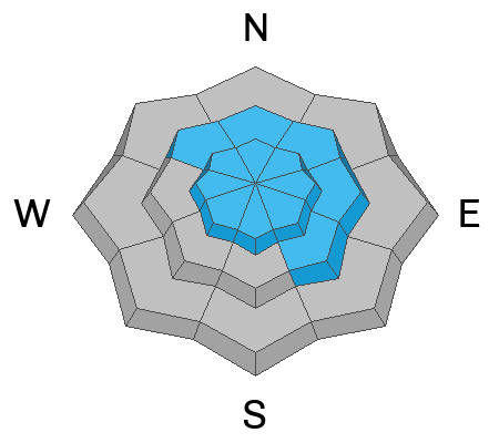
Heavy snowfall and strong winds have created HIGH avalanche danger on all steep slopes near and above treeline that face NW-N-NE-E. In these areas, thick hard slabs of wind drifted snow exist over top of a weak, unstable snowpack structure and deep and dangerous human-triggered avalanches are very likely. Avalanches may be triggered remotely (from a distance), and have the potential to propagate widely. Give avalanche paths a wide berth by staying out from under steep slopes and well back from ridge crests. Avoid all north facing avalanche terrain.

Most other terrain has CONSIDERABLE avalanche danger and human triggered avalanches are likely. In these areas you will find a combination of new and wind drifted snow problems as well the potential for deeper and more dangerous avalanches failing on a persistent weak layer.

Today is not the day to try and outsmart the problems. Avoiding slopes steeper than 30 degrees is your best strategy.

Low
Moderate
Considerable
High
Extreme
Learn how to read the forecast here
Special Avalanche Bulletin

Warning Times:
Saturday, February 21, 2026 6:00 AM MST – Monday, February 23, 2026 at 6:00 AM MST

What:
The Utah Avalanche Center is warning of dangerous avalanche conditions across all Utah mountains this weekend. This week’s heavy snowfall and strong winds overloaded preexisting weak layers, creating a HIGH avalanche danger across the entire state. With improving weather moving in for the weekend, avalanche accidents are likely in the backcountry. There have already been two tragic avalanche fatalities this week, as well as several close calls and numerous backcountry avalanches reported.

Where:
The mountains of Utah and southeastern Idaho.

Impacts:
Dangerous avalanche conditions exist in the backcountry and will persist through the weekend. Natural avalanches are possible, and people are likely to trigger avalanches on slopes steeper than 30 degrees. Dangerous and deadly avalanches can be triggered remotely (from a distance or from below). People leaving ski area boundaries are entering the backcountry where the same dangerous avalanche conditions exist.

Special Announcements

Geyser Pass Road Conditions: Grand County will be plowing the road this morning and the gate will be closed while work is in progress. Although they may finish sooner, noon is a safe bet.

Grooming: Trails are covered in fresh snow.

The UAC is deeply saddened to report two avalanche fatalities. The first occurred on Wednesday, February 18th in the Big Flat area of Snake Creek near Midway. A snowmobiler was caught, carried, and buried in an avalanche, and unfortunately, recovery efforts were unsuccessful. The second fatality occurred on Thursday, February 19th in the backcountry adjacent to Brighton Ski Resort. A girl skiing was caught, carried, and buried by an avalanche and did not survive. Our sincerest condolences are with all those impacted. The UAC is investigating both accident sites in partnership with local law enforcement.

Weather and Snow

24 Hour Snow: 10" 72 Hour Snow: 18" Season Total Snow: 71" Depth at Gold Basin: 46"

Winds on Pre-Laurel Peak: NW light to moderate Temp: -2°F

Weather

The calm after the storm has set in and so have frigid temperatures. Under clear skies temperatures are sub zero and winds blowing from the northwest are mostly light. Moderate to strong winds however, blew during much of the storm yesterday, first from the south before shifting to the west, and finally northwest. Today, look for sunny skies, light westerly winds, and high temperatures creeping up into the low 20's at 10,000 feet. Another beautiful day is on tap for Sunday with slightly warmer temperatures.

General Conditions

After watching storms earlier in the week dump all around us, this last storm scored a direct hit delivering 14 inches of new, low density powder. This brings totals for the week up to 22 inches although I'm not really believing the water amounts at just over 1.0 inch. It seems like it should be more. I don't have any reports from the backcountry yesterday but suffice to say, it's deep out there and conditions are dangerous. The recent snow has fallen on a very weak and faceted snowpack and red flags were already presenting themselves on Thursday, most notably this large avalanche that Dave was able to intentionally trigger from the ridge. We also observed some isolated cracking and collapsing in soft slabs of wind stiffened snow below treeline. Sam Van Wetter and Evan Clapper also observed these red flag signs of instability.

Sam Van Wetter and Evan Clapper observed this crack and collapse on a north facing slope below treeline on Thursday, an obvious red flag sign of instability.

See all recent observations here.

Snowpack and Weather Data

SNOTEL site near Geyser Pass Winter Trailhead (9600')
Wind Station on Pre-Laurel Peak (11,400')
NWS forecast for the La Sal Mountains.
Recent Avalanches
On Thursday, Dave and I were stomping around on the Laurel Ridge and he was able to intentionally trigger this large avalanche in the Horse Creek Chutes. Initiating as a hard wind slab two feet thick, it failed on the Dry January facet layer that was covered on February 11, before stepping down to the ground on facets beneath the Christmas Rain Crust. Exactly the kind of deep and dangerous avalanche we've been warning about.

See all La Sal avalanches here.

Avalanche Problem #1
Persistent Weak Layer
Type
Location
Likelihood
Size
Description

Thick hard slabs of wind drifted snow have formed over top of a snowpack comprised entirely of weak faceted layers on slopes facing NW-N-NE-E. Deep and dangerous human triggered avalanches failing on any one of these persistent weak layers are certain today. Most avalanches will initially fail on a layer of preserved near surface facets that were covered up on February 11, before stepping down deeper into the snowpack. This is all academic however. Any triggered avalanche in these areas will be virtually unsurvivable. Poor snowpack structure exist on west aspects as well, but the over riding slabs are not as deep an hard. Nevertheless, these slopes are not to be trifled with. Avoid all avalanche terrain facing W-N-E.

Avalanche Problem #2
Wind Drifted Snow
Type
Location
Likelihood
Size
Description

Strong southerly winds throughout the week have formed thick hard slabs on northerly aspects. Dangerous enough in and of themselves, triggered wind slabs in these areas will absolutely step down into buried weak layers. A shift in wind direction to the northwest yesterday likely transported snow on to more southerly aspects with the likelihood increasing with elevation. Look for slabs of wind drifted snow on the leeward sides of ridge crests and terrain features such as gully walls and sub ridges. Avoid slopes that have a smooth, rounded appearance. Cracking is a sign of instability.

Avalanche Problem #3
New Snow
Type
Location
Likelihood
Size
Description

The recent snow was very light and I don't expect it to be very slabby, but the shear amount warrants caution. Besides the extra weight it has placed on our fragile snowpack, it will be prone to sluffing, and loose, dry avalanches will be possible to likely in very steep terrain. In areas where it has been stiffened by the wind, you may find some soft slab formation within the new snow. If you are noticing blocks of snow on the edges of your skin track, or cracking in the snow surface, you have found a slab increasing the likelihood for an avalanche.

On Thursday we observed developing slab conditions in the recent snow indicated by this block of snow falling into the skin track.

Additional Information
General Announcements
This forecast is from the U.S.D.A. Forest Service, which is solely responsible for its content. This forecast describes general avalanche conditions and local variations always occur.