Forecast for the Moab Area Mountains

Eric Trenbeath
Issued by Eric Trenbeath on
Friday morning, February 20, 2026

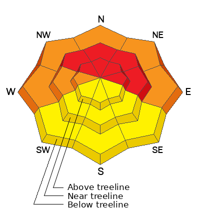
Additional snowfall and strong winds have driven the avalanche danger back up to HIGH on all steep slopes near and above treeline that face NW-N-NE-E. In these areas, thick hard slabs of wind drifted snow exist over top of a weak, unstable snowpack structure and deep and dangerous human-triggered avalanches are all but certain. Avalanches may be triggered remotely (from a distance), and have the potential to propagate widely. Give avalanche paths a wide berth by staying out from under steep slopes and well back from ridge crests. Avoid all north facing avalanche terrain.

A CONSIDERABLE avalanche danger exists on west facing slopes at all elevations and on lower elevation, northerly aspects. In these areas, soft slabs of recent storm and wind drifted snow exist over top of a weak and shallow snowpack and many slopes are teetering on the brink. Avoid slopes steeper than 30 degrees.

A MODERATE danger can be found on most south facing slopes where isolated slabs of wind drifted snow may exist on the leeward sides of terrain features. Soft slabs of wind thickened storm snow may also exist. Look for signs of instability such as cracking in the snow surface and avoid steep slopes where these signs are present.

Low
Moderate
Considerable
High
Extreme
Learn how to read the forecast here
Special Avalanche Bulletin

Warning Times:
Friday, February 20, 2026 6:00 AM MST – Monday, February 23, 2026 at 6:00 AM MST

What:
The Utah Avalanche Center is warning of dangerous avalanche conditions across all Utah mountains this weekend. This week’s heavy snowfall and strong winds overloaded preexisting weak layers, creating a HIGH avalanche danger across the entire state. With improving weather moving in for the weekend, avalanche accidents are likely in the backcountry. There have already been two tragic avalanche fatalities this week, as well as several close calls and numerous backcountry avalanches reported.

Where:
The mountains of Utah and southeastern Idaho.

Impacts:
Dangerous avalanche conditions exist in the backcountry and will persist through the weekend. Natural avalanches are possible, and people are likely to trigger avalanches on slopes steeper than 30 degrees. Dangerous and deadly avalanches can be triggered remotely (from a distance or from below). People leaving ski area boundaries are entering the backcountry where the same dangerous avalanche conditions exist.

Special Announcements

Geyser Pass Road Conditions: The road is not plowed. Crews may make it up this afternoon. Expect drifts up to a foot deep up high. 4x4 required.

Grooming: Trails are covered in fresh snow.

The UAC is deeply saddened to report two avalanche fatalities. The first occurred on Wednesday, February 18th in the Big Flat area of Snake Creek near Midway. A snowmobiler was caught, carried, and buried in an avalanche, and unfortunately, recovery efforts were unsuccessful. The second fatality occurred on Thursday, February 19th in the backcountry adjacent to Brighton Ski Resort. A girl skiing was caught, carried, and buried by an avalanche and did not survive. Our sincerest condolences are with all those impacted. The UAC is investigating both accident sites in partnership with local law enforcement.

Weather and Snow

24 Hour Snow: 4" 72 Hour Snow: 8" Season Total Snow: 61" Depth at Gold Basin: 38"

Winds on Pre-Laurel Peak: SSE 25-30 G 42 Temp: 17°F

Weather

Data is a little spotty this morning but it started snowing around 3:00 AM and looks like 4-5 inches have fallen. Continued snowfall is expected through this morning with another 3-5 inches possible. Winds blowing from the SSE are cranking. They should back off a little and swing to more westerly later today. High temps will stay right about where they are, mid teens at 10,000 feet. Look for gradual clearing tonight with temperatures cratering to near 0°F. Saturday looks to be sunny and clear.

General Conditions

Dave and I took a tour yesterday under mostly clear skies to have a look around after the mid-week storm event. We did not observe any natural avalanches but red flags were abundant, most notably this large avalanche that Dave was able to intentionally trigger from the ridge. We also observed some isolated cracking and collapsing in soft slabs of wind stiffened snow below treeline. Sam Van Wetter and Evan Clapper also observed these red flag signs of instability.

We're up to around a foot of snow and inch of water weight so far this week. This incremental loading may not seem like much, but yesterday's avalanche shows how little it takes to trigger our incredibly weak and faceted snowpack. With more wind and snow in the forecast today you're going to really need to dial it back. Look for soft snow in low angled sheltered terrain.

Sam Van Wetter and Evan Clapper observed this crack and collapse on a north facing slope below treeline, an obvious red flag sign of instability.

See all recent observations here.

Snowpack and Weather Data

SNOTEL site near Geyser Pass Winter Trailhead (9600')
Wind Station on Pre-Laurel Peak (11,400')
NWS forecast for the La Sal Mountains.
Recent Avalanches
Yesterday, Dave and I were stomping around on the Laurel Ridge and he was able to intentionally trigger this large avalanche that went cascading into Horse Creek. Initiating as a hard wind slab two feet thick, it failed on the near surface facet layer that was covered on February 11, before stepping down to the ground on facets beneath the Christmas Rain Crust. Exactly the kind of deep and dangerous avalanche we've been warning about.

See all La Sal avalanches here.

Avalanche Problem #1
Persistent Weak Layer
Type
Location
Likelihood
Size
Description

Thick hard slabs of wind drifted snow have formed over top of a snowpack comprised entirely of weak faceted layers on slopes facing NW-N-NE-E. Deep and dangerous human triggered avalanches failing on any one of these persistent weak layers are certain today. Most avalanches will initially fail on a layer of preserved near surface facets that were covered up on February 11, before stepping down deeper into the snowpack. This is all academic however. Any triggered avalanche in these areas will be virtually unsurvivable. Poor snowpack structure exist on west aspects as well, but the over riding slabs are not as deep an hard. Nevertheless, these slopes are not to be trifled with. Avoid all avalanche terrain facing W-N-E.

Avalanche Problem #2
Wind Drifted Snow
Type
Location
Likelihood
Size
Description

Strong southerly winds have formed thick hard slabs on northerly aspects. Dangerous enough in and of themselves, triggered wind slabs in these areas will absolutely step down into buried weak layers. The same holds true for slopes facing west, although the slabs aren't as thick and hard. Isolated slabs of wind drifted snow may exist on south facing slopes with the likelihood increasing with elevation. Look for slabs of wind drifted snow on the leeward sides of ridge crests and terrain features such as gully walls and sub ridges. Avoid slopes that have a smooth, rounded appearance. Cracking is a sign of instability.

Additional Information
General Announcements
This forecast is from the U.S.D.A. Forest Service, which is solely responsible for its content. This forecast describes general avalanche conditions and local variations always occur.