Forecast for the Moab Area Mountains

Dave Garcia
Issued by Dave Garcia on
Wednesday morning, February 18, 2026

Weak, unstable snowpack structure is widespread, and continued wind loading and new snowfall will drive the avalanche danger to HIGH today. Natural avalanches are likely, and human-triggered avalanches are very likely, failing on a recently buried persistent weak layer. Leeward slopes near and above treeline hold widespread, freshly formed drifts resting on very weak facets. Wind slab avalanches may initiate around two feet deep, but could step down into deeper weak layers and release the entire season’s snowpack.

Travel in avalanche terrain is not recommended.

Most southerly-facing terrain has a MODERATE danger, where you may find recent, shallow drifts that are poorly bonded to the hard crusts beneath.

Low
Moderate
Considerable
High
Extreme
Learn how to read the forecast here
Special Announcements

Geyser Pass Road Conditions: The road is not plowed. Expect a couple inches of fresh snow over ice up high. AWD recommended.

Grooming: Trails are covered in fresh snow.

We have rescheduled our Moab Backcountry 101 Class to February 20, 21. Click here for information and registration. Moab and Monticello locals can use the discount code MOAB-LOCAL for a 10% discount.

Weather and Snow

24 Hour Snow: 0" 72 Hour Snow: 4" Season Total Snow: 53" Depth at Gold Basin: 34"

Winds on Pre-Laurel Peak: S 20 G 30 Temp: 20°F

Weather

Under cloudy skies, it is 20°F in Gold Basin this morning. Snow will begin to fall around 10 AM, and the heaviest precipitation is expected during the middle of the day. We can expect an additional 4 to 6 inches of snow to accumulate. Winds will blow strongly from the southwest, averaging 35 MPH with gusts up to 60 MPH. The storm clears out tonight, and Thursday will be sunny, cold, and windy. Friday brings yet another chance for snow, and we'll have more details on Friday's storm soon.

General Conditions

A quick-hitting storm dropped four inches of snow at 0.56" SWE (snow water equivalent) in the early morning hours on Tuesday. It's nice to see some new snow, but in all honesty, the skiing conditions weren't that great. The new snow is heavy. While turning it feels very upside-down, slabby, and grabby. At least it will cover up some rocks. The new snow also came with strong to extreme southerly winds, and many windward slopes were blown off down to the old crusts.

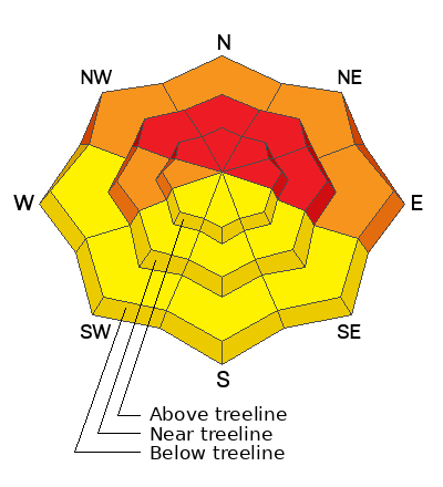
A widespread layer of near-surface facets was buried on Wednesday night, 2/11, creating a fragile snowpack structure. At first, the hazard was elevated but lacked a cohesive slab. The latest storm changed that, delivering dense snow and forming a widespread slab, even in sheltered terrain. Yesterday, I observed cracking and collapsing on slopes below treeline—clear signs the snowpack is reactive. Conditions were more concerning near and above treeline on leeward slopes, where sensitive wind slabs up to two feet deep have formed over weak facets. Drifted slopes are the primary concern today.

Additional snowfall, strong winds, and active drifting will overload an already fragile structure. Many slopes on the north half of the compass harbor multiple layers of weak, faceted snow. As loading continues, avalanche danger will rise to HIGH. Keep travel simple: avoid slopes steeper than 30 degrees and stay out from under steeper terrain.

See the video below for a summary of yesterday's fieldwork

See all recent observations here.

Snowpack and Weather Data

SNOTEL site near Geyser Pass Winter Trailhead (9600')
Wind Station on Pre-Laurel Peak (11,400')
NWS forecast for the La Sal Mountains.
Recent Avalanches
Yesterday I spotted this natural avalanche on the steep north face of Exxon's Folly. Details are sparse because of poor visibility, but judging by the debris pile, this is easily a D2 avalanche.
See all La Sal avalanches here.
Avalanche Problem #1
Persistent Weak Layer
Type
Location
Likelihood
Size
Description

The entire snowpack is faceted through on shady aspects, providing a variety of weak layers. The immediate layer of concern is the old snow surface from before the storm on the night of February 11. This is the most sensitive of our many weak layers, and the easiest to trigger. Out of the wind zone, you can trigger a soft slab avalanche that will initially be about ten inches deep. On steep, continuous slopes, these relatively shallow avalanches can entrain enough snow to step down to more deeply buried weak layers, causing a deeper and more dangerous avalanche. On slopes that have seen recent drifting, the most prominent weak layer of concern is buried two feet below the surface. On these slopes, you can trigger avalanches that will initially be two feet deep and will almost certainly step down (possibly to the ground), causing very large and destructive avalanches. Keep it simple and avoid avalanche terrain.

Avalanche Problem #2
Wind Drifted Snow
Type
Location
Likelihood
Size
Description

Southerly winds have been strong to extreme since the onset of the storm and will continue to blow and drift snow today. In my travels yesterday, I found hard slabs (1F density) up to two feet deep of recently drifted snow. These slabs sit above a very weak snowpack structure and produced loud collapses and shooting cracks up to 100 feet long. These drifts will grow in size today. If you skied out onto this type of drift, you are very likely to trigger a large avalanche that will bury and kill you.

Additional Information
General Announcements
This forecast is from the U.S.D.A. Forest Service, which is solely responsible for its content. This forecast describes general avalanche conditions and local variations always occur.