Forecast for the Moab Area Mountains

Eric Trenbeath
Issued by Eric Trenbeath on
Tuesday morning, February 17, 2026

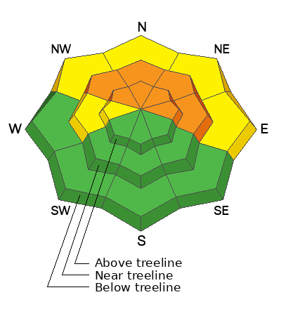
The avalanche danger is CONSIDERABLE on steep slopes near and above treeline that face NW-N-NE-E. In these areas, wind drifted snow is beginning to stress buried persistent weak layers and human triggered avalanches are likely, natural avalanches are possible. With continued strong winds today, overhead hazard will be a concern. Stay out from under big, north and easterly facing slopes.

A MODERATE danger exists on west aspects where cross-loading of wind drifted snow is also stressing buried weak layers. Avoid slopes that have a smooth rounded appearance or where the snow has thickened into a slab. Cracking is a sign of instability.

Most south facing terrain has LOW danger. Small slabs of wind drifted snow may exist on isolated terrain features.

Low
Moderate
Considerable
High
Extreme
Learn how to read the forecast here
Special Announcements

Geyser Pass Road Conditions: The road is not plowed. Expect a couple inches of fresh snow over ice up high. AWD recommended.

Grooming: Trails are covered in fresh snow.

We have rescheduled our Moab Backcountry 101 Class to February 20, 21. Click here for information and registration. Moab and Monticello locals can use the discount code MOAB-LOCAL for a 10% discount.

Weather and Snow

24 Hour Snow: 5" 72 Hour Snow: " Season Total Snow: 54" Depth at Gold Basin: 35"

Winds on Pre-Laurel Peak: SSE 30-40 G 60 Temp: 19°F

Weather

It's certifiably crazy up there this morning with howling southerly winds blowing in excess of 50 mph. And it's snowing with 3 inches falling in one hour between 4:00 and 5:00 AM! Snowfall should quickly taper off this morning but the winds won't. They'll continue to blow from the southwest in the 30-35 mph range with gusts in the 50's. High temperatures will be in the low 20's at 10,000 feet. Snowfall returns in the early morning hours on Wednesday as a more organized shortwave trough moves into the region. Another 6 inches are possible and southwest winds will remain strong. We'll see a break in the action on Thursday with yet another storm on Friday.

General Conditions

The landscape has changed and it's going to be wild up there today. Expect to find alternating areas of wind blown snow and scoured exposed surfaces. You will really need to seek out sheltered areas to take advantage of the new snow today. Drifted snow has significantly increased the danger on steep, northerly aspects where the underlying snowpack is comprised of multiple weak layers of faceted snow. The snowpack is teetering on the edge and will likely break over the next several days. These slopes are now off limits for the foreseeable future.

See all recent observations here.

Snowpack and Weather Data

SNOTEL site near Geyser Pass Winter Trailhead (9600')
Wind Station on Pre-Laurel Peak (11,400')
NWS forecast for the La Sal Mountains.
Recent Avalanches
See all La Sal avalanches here.
Avalanche Problem #1
Persistent Weak Layer
Type
Location
Likelihood
Size
Description

The entire snowpack is faceted through on shady aspects providing a variety of weak layers. The immediate layer of concern is the old snow surface prior to the storm on February 12. Slab avalanches failing on this layer could be 1-2 feet deep. The danger is most acute on slopes that have seen recent wind drifting which is the real factor today. Avalanches failing deeper in the snowpack will become increasingly more likely over the coming days. A foot or more of accumulated new snow over the next several days will put us over the edge and I would anticipate a natural cycle.

Avalanche Problem #2
Wind Drifted Snow
Type
Location
Likelihood
Size
Description

Wind drifted snow is the prime force behind our increasing avalanche danger today. And although wind slabs up to a foot deep can be problematic in themselves, the real danger is the stress they are applying to our weak snowpack. On northerly aspects it's a no-brainer - avoid all steep, wind drifted slopes. On west aspects, cross-loading may be a factor. Look for more isolated deposits on the leeward sides of terrain features such as gully walls and sub ridges. Wind slabs triggered on west aspects may also step down into buried weak layers of faceted snow. Wind drifts are recognizable by their smooth, rounded appearance and cracking is a sign of instability.

Additional Information
General Announcements
This forecast is from the U.S.D.A. Forest Service, which is solely responsible for its content. This forecast describes general avalanche conditions and local variations always occur.