Forecast for the Moab Area Mountains

Dave Garcia
Issued by Dave Garcia on
Friday morning, February 13, 2026

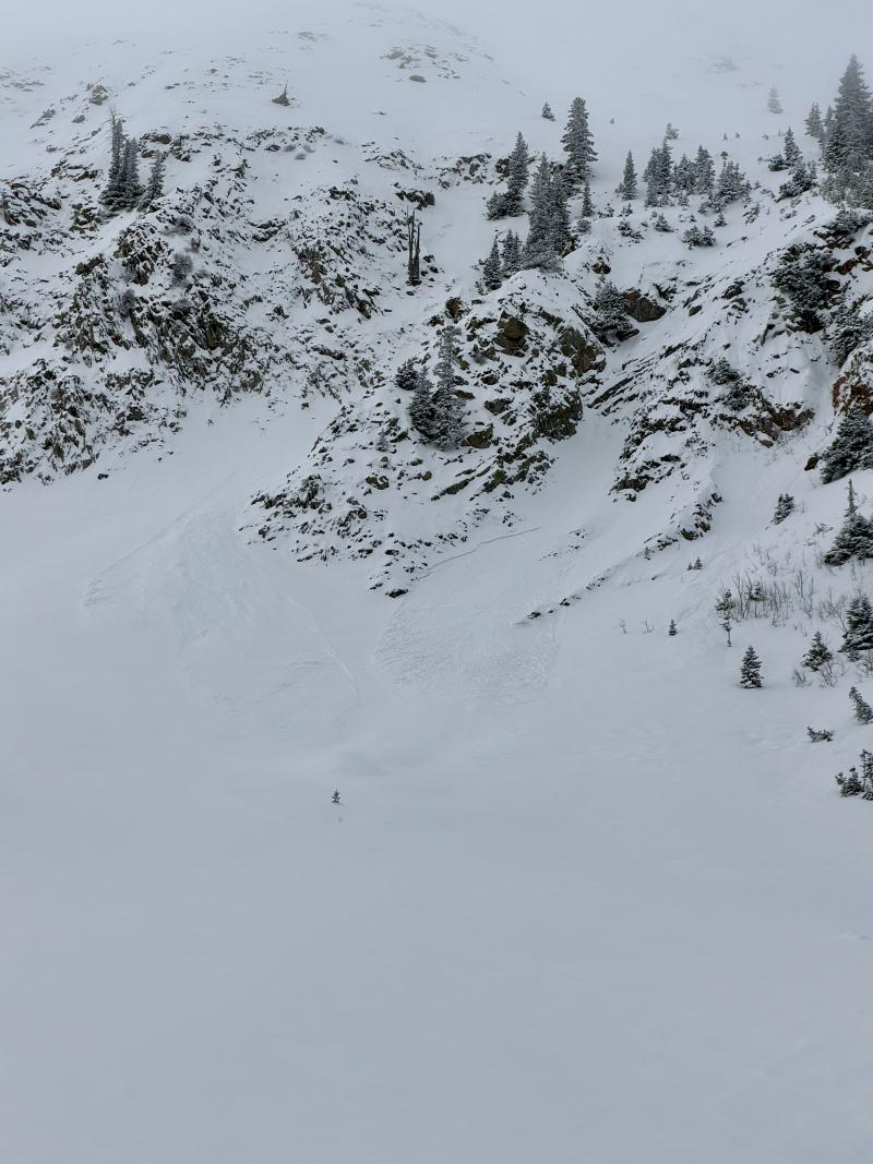
We begin the day at MODERATE danger with a widespread, well-preserved persistent weak layer of buried facets. This morning, skiers and riders can trigger shallow soft slab avalanches on steep slopes that face W-N-E.

Snow is in the forecast, and if totals come in on the higher end, the danger will rise through MODERATE and reach CONSIDERABLE by the end of the day. Soft slabs will increase in size and distribution. Natural avalanches will become possible, and human-triggered avalanches will become likely. Watch for rapidly accumulating snow and increasing red flags such as cracking and collapsing as additional loading stresses the weak layer.

Low
Moderate
Considerable
High
Extreme
Learn how to read the forecast here
Special Announcements

Check out this recent blog post from Forest Service UAC Director Paige Pagnucco Weak Snow: Today's Surface, Tomorrow's Avalanche Problem.

Drew Hardesty has a new blog titled "The Greatest Rain on Earth."

Geyser Pass Road Conditions: The road has not been plowed, expect it to be snow-covered. AWD with good tires recommended.

Grooming: LUNA groomed all trails yesterday.

We are looking to reschedule our Moab Backcountry 101 Class to February 20, 21 in the hopes that we will have more snow. Click here for information and registration. Moab and Monticello locals can use the discount code MOAB-LOCAL for a 10% discount.

Weather and Snow

24 Hour Snow: 0" 72 Hour Snow: 4" Season Total Snow: 48" Depth at Gold Basin: 30"

Winds on Pre-Laurel Peak: SW 10 G 15-20 Temp: 25°F

Weather

Under cloudy skies, it is 25°F in Gold Basin this morning. High temperatures will top out at 28° F today, and winds will blow just 5-10 MPH from the southwest. Winds will shift and blow from the northwest this evening. Another round of snow will fall today, and it seems likely we will pick up an additional 3-6 inches by tonight. A brief lull occurs over the weekend with dry and warm conditions before the pattern shifts to a cooler and unsettled one with potential for more mountain snow Tuesday and onwards.

General Conditions

The pre-existing snow surface was highly variable, and four inches of new snow on Wednesday night has improved riding conditions. Southerly aspects were previously crusted, but the new snow fell with relatively warm temperatures, promoting decent bonding and an overall low avalanche hazard on these slopes.

Weak and faceted snow is widespread west to north to east, and is now buried by four inches of new snow and 0.4 inches of SWE (snow water equivalent). In my travels yesterday I found the buried weak layer to be very sensitive, but the small load and relatively uncohesive storm snow just wasn't enough to push things over the edge. If you are in the mountains today, it will be very important to keep track of how much snow accumulates and how the weak layer behaves with continued loading. My hunch is that as we creep toward 1 inch of accumulated SWE (including Wednesday night's 0.4"), the wheels will start to come off, and we will see cracking, collapsing, and touchy conditions under the weight of a skier or rider. This all depends on whether the storm delivers, but if we receive the upper end of forecasted snow totals, the avalanche danger could reach CONSIDERABLE by the end of the day.

See all recent observations here.

Snowpack and Weather Data

Gold Basin SNOTEL site (10,000')
SNOTEL site near Geyser Pass Winter Trailhead (9600')
Wind Station on Pre-Laurel Peak (11,400')
NWS forecast for the La Sal Mountains.
Recent Avalanches
Yesterday, I spotted this natural soft slab avalanche in Upper Tele Gold. With additional loading today, these avalanches will grow in size and frequency.
See all La Sal avalanches here.
Avalanche Problem #1
Persistent Weak Layer
Type
Location
Likelihood
Size
Description

Our new snow avalanche problem has transitioned into a persistent weak layer problem. A widespread layer of faceted snow on the surface was buried on Wednesday night. The weak layer of concern exists at all elevation bands and is easy to identify. This layer has proven to be very sensitive, and if today's storm delivers, we will begin to see a natural avalanche cycle. The strategy today is to pay attention to snowfall rates. Any period of intense precipitation will result in a corresponding rise in danger. Before the snow falls, you won't see many red flags. As the snow piles up, you may start to see indications of unstable snow, such as cracking and collapsing. Ski cuts on small tests slopes will tell you a lot about how the weak layer is responding to the new load. The weak layer is shallowly buried, and hand shear tests are a quick and easy way to look for instability.

We are most concerned about the recently buried weak layer, and avalanches will initiate here first, but many weak layers exist in the snowpack. Once triggered, any avalanche has the potential to step down, causing a deeper and more dangerous avalanche.

Additional Information
General Announcements
This forecast is from the U.S.D.A. Forest Service, which is solely responsible for its content. This forecast describes general avalanche conditions and local variations always occur.