Forecast for the Moab Area Mountains

Eric Trenbeath
Issued by Eric Trenbeath on
Saturday morning, February 14, 2026

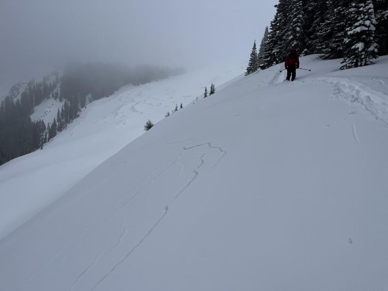
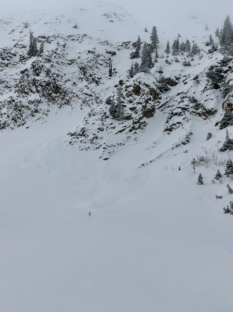
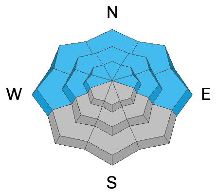
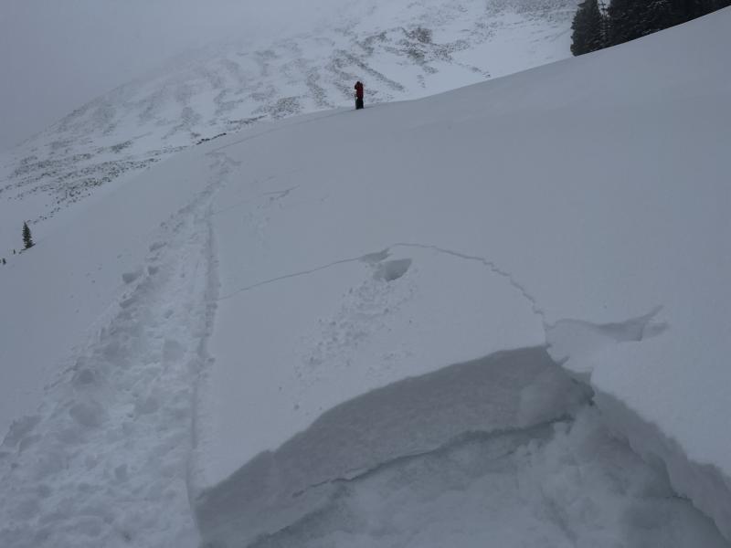
An overall MODERATE avalanche danger exists on steep slopes near and above treeline that face W-N-E. In these areas, human triggered soft slab avalanches failing on a persistent weak layer of faceted snow are possible.

Moderate means the danger isn't widespread but there are definitely areas where you can trigger an avalanche. You are most likely to find trouble on steep, wind drifted slopes right around treeline and above that have a north or easterly component to their aspect. Signs of instability include collapsing and cracking in the snow surface. Avoid steep slopes where these signs are present and be mindful of overhead hazard.

Low
Moderate
Considerable
High
Extreme
Learn how to read the forecast here
Special Announcements

Check out this recent blog post from Forest Service UAC Director Paige Pagnucco Weak Snow: Today's Surface, Tomorrow's Avalanche Problem.

Drew Hardesty has a new blog titled "The Greatest Rain on Earth."

Geyser Pass Road Conditions: The road has not been plowed, expect it to be snow-covered. AWD with good tires recommended.

Grooming: LUNA will be up again grooming this morning.

We are looking to reschedule our Moab Backcountry 101 Class to February 20, 21 in the hopes that we will have more snow. Click here for information and registration. Moab and Monticello locals can use the discount code MOAB-LOCAL for a 10% discount.

Weather and Snow

24 Hour Snow: 1" 72 Hour Snow: 5" Season Total Snow: 49" Depth at Gold Basin: 31"

Winds on Pre-Laurel Peak: NW 10-15 G 22 Temp: 16°F

Weather

Look for sunny skies, mostly light winds blowing from the northwest, and high temperatures in the low to mid 30's at 10,000 feet. Skies will remain clear over night and into Sunday morning. Look for increasing clouds and southerly winds later in the day. An active weather pattern is lining up for next week.

General Conditions

Yesterday's storm turned out to be a bust but we've picked up 5 inches of new snow since Thursday and it has provided a nice refresh. The recent snow has fallen on a variety of surfaces, most notably, weak, faceted snow on shady aspects. In our travels yesterday, Jason Ramsdell and I observed soft slab development within the recent storm snow as well as cracking and collapsing along exposed ridge lines. Nate Ament and Chloe Hollis observed similar conditions.

Shooting cracks along a NE facing ridge crest right at treeline. Avoid steep wind drifted slopes, especially if you see red flags such as this.

See all recent observations here.

Snowpack and Weather Data

SNOTEL site near Geyser Pass Winter Trailhead (9600')
Wind Station on Pre-Laurel Peak (11,400')
NWS forecast for the La Sal Mountains.
Recent Avalanches
Dave spotted this natural soft slab avalanche in Upper Tele Gold on Thursday. This is fairly indicative of the type and size of avalanche you are most likely to encounter.
See all La Sal avalanches here.
Avalanche Problem #1
Persistent Weak Layer
Type
Location
Likelihood
Size
Description

Underneath the recent snow, the snowpack is entirely faceted through on shady aspects providing a variety of weak layers. Although the recent snow has not provided enough of a load to completely tip the scales, the trigger is set and human triggered avalanches failing on a persistent weak layer are possible to likely. The immediate layer of concern is right beneath the recent snow and it is already proving to be sensitive to the weight of a skier or rider. Soft slab avalanches failing on this layer could be up to a foot deep and 100 feet wide. A less likely scenario would be for a failure to occur deeper in the snowpack, but if we increase the load this week, this scenario will become all but certain.

Slab within the recent snow failing on a layer of now buried, near surface facets. The snowpack is primed and ready for avalanches.

Additional Information
General Announcements
This forecast is from the U.S.D.A. Forest Service, which is solely responsible for its content. This forecast describes general avalanche conditions and local variations always occur.