Forecast for the Logan Area Mountains

Toby Weed
Issued by Toby Weed on
Tuesday morning, February 17, 2026

A powerful winter storm will rapidly increase avalanche danger in the backcountry today. In upper and mid-elevation terrain, the danger is already CONSIDERABLE, with drifted storm snow overloading a widespread layer of weak faceted snow on many slopes. Very dangerous avalanche conditions will develop by this evening, raising the danger to HIGH in drifted upper elevation terrain. Natural and human-triggered avalanches are increasingly likely.

People should avoid travel in avalanche terrain; stay off and well out from under slopes steeper than 30°

Low
Moderate
Considerable
High
Extreme
Learn how to read the forecast here
Avalanche Watch

What: Heavy snowfall and strong winds are increasing avalanche danger across the mountains of Northern and Central Utah, as well as Southwestern Utah and Southeast Idaho. Forecasters at the Utah Avalanche Center expect dangerous, complex avalanche conditions to develop on many slopes this week, with large natural and human-triggered avalanches likely.

When: This Avalanche Watch is issued on Tuesday, 2/17/26 at 6:00 AM MST through 6:00 AM MST Wednesday, 2/18/26.

Where:
The Avalanche Watch is for the mountains of Northern, Central, and Southwestern Utah, as well as Southeastern Idaho.

Impacts:

  • Dangerous avalanche conditions are expected to develop on many slopes.

  • Avalanches can be triggered on slopes steeper than 30 degrees. They may also be triggered remotely (from a distance) or from below.

What to do:

  • Avoid traveling on or underneath steep terrain at mid and upper elevations in the backcountry.

  • Carry and know how to use avalanche rescue equipment, including a transceiver, shovel, and probe.

  • Find safer riding conditions on slopes less than 30 degrees with no overhead hazard.

For updated avalanche information, visit www.utahavalanchecenter.org.

Weather and Snow

This map from the National Weather Service shows expected snowfall for the next few days...

Today, a powerful winter storm will continue to elevate avalanche danger in drifted upper and mid elevation terrain, especially on northerly facing slopes that are steeper than 30 degrees. Thick slabs of wind-drifted snow are rapidly building in lee areas of exposed ridgelines and in and around terrain features, such as gullies and rock bands. Before snow started falling last night, terrain below about 7000 feet had only very shallow, if any, snow cover, with muddy access trails, dry trailhead parking lots, and sunny slopes facing southeast through west completely bare of snow.

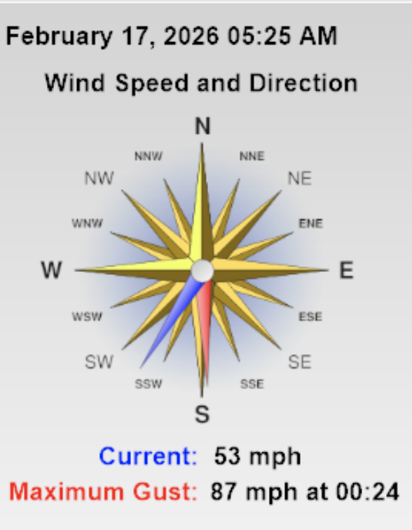
Currently, winds on Logan Peak are blowing from the southwest around 40 mph, with a gust of 87 mph recorded early this morning. It's 18°F on Paris Peak at 9500 feet, and the wind is blowing 26 to 43 mph from the south-southwest. At 8700 feet, the UAC Card Canyon station reports 20°F and 7 inches of new snow, and there's 50 inches of total snow. The Tony Grove Snotel, located at 8400 feet, reports 30°F, and 11 inches of new snow with 1.3 inches of SWE, and 64 inches of total snow.

The National Weather Service has continued a Winter Storm Warning for the mountains in the Logan Zone, beginning tonight through Wednesday night. We can expect heavy snowfall in the mountains today, with 6 to 10 inches of accumulation possible. High temperatures at 8500 feet will be around 25°F, and very strong and gusty winds from the west-southwest are expected. The powerful winter storm will continue tonight and tomorrow, with another 2 feet of snow possible in favored upper elevation terrain. Unsettled weather conditions will continue through the week, with clearing likely for the weekend.

Recent Avalanches

For all observations and avalanche activity in the Logan zone, go HERE

Avalanche Problem #1
Wind Drifted Snow
Type
Location
Likelihood
Size
Description

Avalanches of wind-drifted snow will become increasingly likely during the day in lee areas near ridgelines and in and around exposed terrain features in upper elevation terrain, particularly on slopes facing northwest through east.

  • Avalanches could be triggered remotely.
  • Slabs of wind-drifted new snow will form in and around terrain features like sub-ridges, rock outcroppings, gullies, and mid-slope rollovers.
  • Beware if you cause cracking in stiffer drifted snow. Shooting cracks and whumpfing are obvious signs of instability.
  • Even small avalanches can be quite dangerous if you are carried into trees or other terrain traps below.

Avalanche Problem #2
Persistent Weak Layer
Type
Location
Likelihood
Size
Description

Although much low-elevation terrain was bare of snow yesterday, we expect the avalanche danger to rise significantly higher in the backcountry as preexisting layers of very weak snow are overloaded by heavy storm snow and drifting...

Paige explains how different types of weak snow that develop during periods of benign weather can become persistent weak layers when buried by future snows. We expect dangerous avalanche conditions to develop as persistent weak layers are overloaded by heavy snow this week.

Avalanche Problem #3
New Snow
Type
Location
Likelihood
Size
Description

As snow rapidly stacks up on steep slopes, it is likely to become unstable. Whether or not avalanches fail on pre-existing weak layers or layers that develop within the snow becomes irrelevant at some point. Natural avalanches of storm snow are most likely during periods of exceptionally heavy snowfall

Additional Information
  • Travel with a partner, and cross or ride slopes steeper than 30 degrees one at a time while the rest of your group watches from a safe spot.
  • Ensure that everyone in the group has avalanche rescue equipment (a transceiver, probe, and shovel) and knows how to use it.

-----------------------------------------------------------------------------------------------------------------------------------------------------------------

Join the UAC for the first "Stay and Play Avalanche Course" at Bear River Lodge in the Uintas, March 19th-22nd. This course is designed for snowmobilers by snowmobilers, where you will learn avalanche rescue, riding skills, and how to survive in the backcountry. Come enjoy all the luxury offerings at Bear River Lodge and improve your skills along the way.

For all questions on forecasts, education, Know Before You Go, events, online purchases, or fundraising, call 801-365-5522.

Did you know the UAC hosts a podcast? Episode 2 of Season IX is just out - AI, Machine Learning, and the Value of Expert Intuition at the Utah Avalanche Center.

Are you interested in learning more about avalanches? Visit our education page for details on all our classes.

For more information, visit the UAC weather page here: UAC Weather Page For Logan-specific weather, go here: Logan Mountain Weather

-Remember, the information you provide could save lives, especially if you see or trigger an avalanche. To report an avalanche or submit an observation from the backcountry, go HERE

-Receive forecast region-specific text message alerts to receive messages about changing avalanche conditions, watches, and warnings. Sign up and update your preferences HERE

This forecast is from the U.S.D.A. Forest Service, which is solely responsible for its content. This forecast describes general avalanche conditions and local variations always occur.

General Announcements
This information does not apply to developed ski areas or highways where avalanche control is normally done. This forecast is from the U.S.D.A. Forest Service, which is solely responsible for its content. This forecast describes general avalanche conditions and local variations always occur.