Forecast for the Logan Area Mountains

Toby Weed
Issued by Toby Weed on
Monday morning, February 16, 2026

Pockets of MODERATE danger exist, and people could trigger shallow wind slab avalanches on upper elevation slopes steeper than 30°.

***A powerful winter storm beginning tonight will rapidly elevate the avalanche danger in the backcountry. With widespread weak faceted snow plaguing many slopes, dangerous avalanche conditions will develop.

Low
Moderate
Considerable
High
Extreme
Learn how to read the forecast here
Avalanche Watch

Heavy snowfall and strong winds are expected to rapidly increase avalanche danger across northern and central Utah beginning tomorrow and continuing through the week. Forecasters at the Utah Avalanche Center expect dangerous and complex avalanche conditions to develop on many slopes, with large natural and human-triggered avalanches likely.

Dangerous avalanche conditions are expected to develop on many slopes. Avalanches can be triggered on slopes steeper than 30 degrees. They may also be triggered remotely (from a distance) or from below.

  • Avoid traveling on or underneath steep terrain at mid and upper elevations in the backcountry.
  • Carry and know how to use avalanche rescue equipment, including a transceiver, shovel, and probe.
  • Find safer riding conditions on slopes less than 30 degrees with no overhead hazard.
Special Announcements

Join the UAC for the first "Stay and Play Avalanche Course" at Bear River Lodge in the Uintas, March 19th-22nd. This course is designed for snowmobilers by snowmobilers, where you will learn avalanche rescue, riding skills, and how to survive in the backcountry. Come enjoy all the luxury offerings at Bear River Lodge and improve your skills along the way.

Weather and Snow

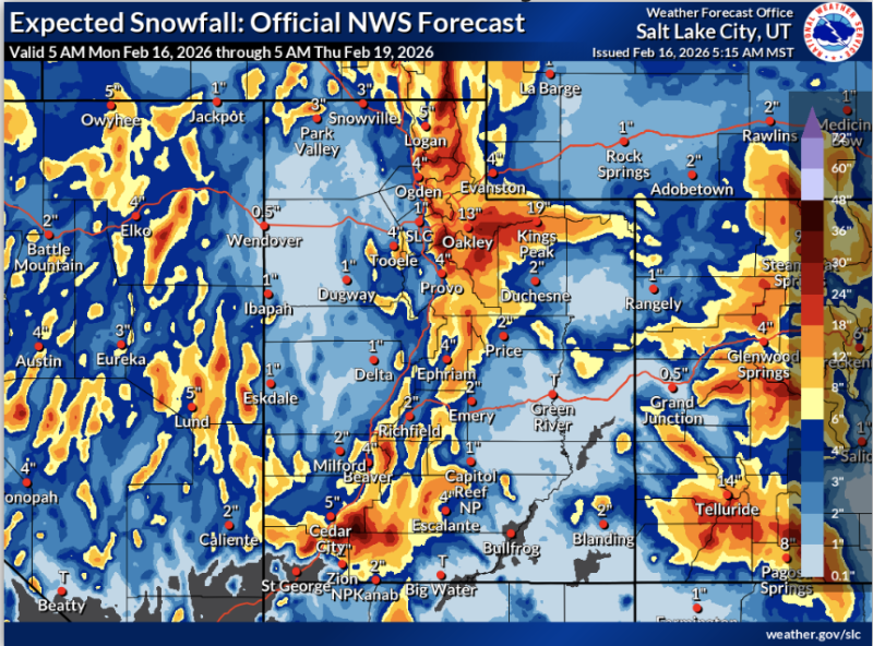
This map from the National Weather Service shows expected snowfall for the next few days...

Today, increasing winds from the south will elevate the avalanche danger in drifted upper elevation terrain, generally on northerly facing slopes that are steeper than 30 degrees. Shallow hard slabs of wind-drifted snow may be sensitive to your weight in lee areas of exposed ridgelines and in and around terrain features, such as gullies and rock bands. Terrain below about 7000 feet has only very shallow, if any, snow cover, with muddy access trails, dry trailhead parking lots, and sunny slopes facing southeast through west completely bare of snow.

Currently, winds on Logan Peak are blowing from the south, 30 to 45 mph. It's 22°F on Paris Peak at 9500 feet, and the wind is blowing 10 to 15 mph from the south, with overnight gusts around 30 mph. At 8700 feet, the UAC Card Canyon station reports 27°F, and there's 43 inches of total snow. The Tony Grove Snotel, located at 8400 feet, reports 30°F, with 54 inches of total snow.

The National Weather Service has issued a Winter Storm Warning for the mountains in the Logan Zone, beginning tonight through Wednesday night. We can expect mostly sunny skies in the mountains today, with high temperatures at 8500' around 38°F and winds from the south-southwest blowing 15 to 24 mph, with gusts as high as 45 mph. A powerful winter storm starts tonight, and snowfall could be heavy at times, with the temperature dropping to around 21°F and 6 to 10 inches of accumulation possible up high. Significant drifting will occur, with a wind from the south-southwest blowing 25 to 33 mph, and gusting as high as 55 mph. Heavy snowfall and strong winds will continue tomorrow, and some thunder is also possible, with 7 to 11 inches of accumulation possible. Expect high temperatures near 25°F, with a wind from the west-southwest 24 to 32 mph, with gusts as high as 55 mph.

Recent Avalanches

For all observations and avalanche activity in the Logan zone, go HERE

Avalanche Problem #1
Wind Drifted Snow
Type
Location
Likelihood
Size
Description

An increase in wind speeds today may create new wind slabs, and it will stiffen up existing ones, in lee areas near ridgelines and in and around exposed terrain features in upper elevation terrain, particularly on slopes facing west, north, and east.

  • Some wind slab avalanches could be triggered remotely.
  • Soft slabs of wind-drifted new snow will form in and around terrain features like sub-ridges, rock outcroppings, gullies, and mid-slope rollovers.
  • Beware if you cause cracking in stiffer drifted snow. Shooting cracks and whumpfing are obvious signs of instability.
  • Even small avalanches can be quite dangerous if you are carried into trees or other terrain traps below.
Avalanche Problem #2
Normal Caution
Type
Location
Likelihood
Size
Description

Although much low-elevation terrain is bare of snow, we expect the avalanche danger to rise significantly higher in the backcountry as preexisting layers of very weak snow are overloaded by heavy storm snow and drifting. Paige explains how different types of weak snow that develop during periods of benign weather can become persistent weak layers when buried by future snows. We expect dangerous avalanche conditions to develop as persistent weak layers are overloaded by heavy snow this week.

Additional Information
  • Travel with a partner, and cross or ride slopes steeper than 30 degrees one at a time while the rest of your group watches from a safe spot.
  • Ensure that everyone in the group has avalanche rescue equipment (a transceiver, probe, and shovel) and knows how to use it.

-----------------------------------------------------------------------------------------------------------------------------------------------------------------

-For all questions on forecasts, education, Know Before You Go, events, online purchases, or fundraising, call 801-365-5522.

Did you know the UAC hosts a podcast? Episode 2 of Season IX is just out - AI, Machine Learning, and the Value of Expert Intuition at the Utah Avalanche Center.

Are you interested in learning more about avalanches? Visit our education page for details on all our classes.

For more information, visit the UAC weather page here: UAC Weather Page For Logan-specific weather, go here: Logan Mountain Weather

-Remember, the information you provide could save lives, especially if you see or trigger an avalanche. To report an avalanche or submit an observation from the backcountry, go HERE

-Receive forecast region-specific text message alerts to receive messages about changing avalanche conditions, watches, and warnings. Sign up and update your preferences HERE

This forecast is from the U.S.D.A. Forest Service, which is solely responsible for its content. This forecast describes general avalanche conditions and local variations always occur.

General Announcements
This information does not apply to developed ski areas or highways where avalanche control is normally done. This forecast is from the U.S.D.A. Forest Service, which is solely responsible for its content. This forecast describes general avalanche conditions and local variations always occur.