Observer Name
UAC Staff
Observation Date
Sunday, February 22, 2026
Avalanche Date
Saturday, February 21, 2026
Region
Salt Lake » Big Cottonwood Canyon » Butler Fork » Butler Basin
Location Name or Route
Butler Basin Accident
Elevation
9,200'
Aspect
North
Slope Angle
38°
Trigger
Skier
Trigger: additional info
Unintentionally Triggered
Avalanche Type
Soft Slab
Avalanche Problem
Persistent Weak Layer
Weak Layer
Facets
Depth
2'
Width
250'
Vertical
100'
Caught
2
Carried
2
Buried - Fully
2
Injured
1
Killed
1
Accident and Rescue Summary
Accident Summary
On the morning of Saturday, February 21, 2026, two skiers left the Butler Fork trailhead in Big Cottonwood Canyon with the intention of skiing a run known as “The Triangle,” located in Butler Basin, a drainage in Big Cottonwood Canyon just east of Gobblers Knob.
The two skiers ascended a steep, north-facing slope adjacent to “The Triangle.” Skier A was nearly at the top of the slope when the avalanche occurred around 10:15 a.m. Both skiers were caught, carried approximately 100 feet down the slope, and fully buried at the bottom.
Three other groups of skiers in the drainage, Group One with two members, Group Two with four members, and Group Three with two members, witnessed the avalanche. The parties notified Alta Central, called 911, and initiated the rescue.
Rescue Summary
Times listed below are approximate and were reconstructed from photos, Strava activity data, and phone call logs. Minor discrepancies of several minutes are possible.
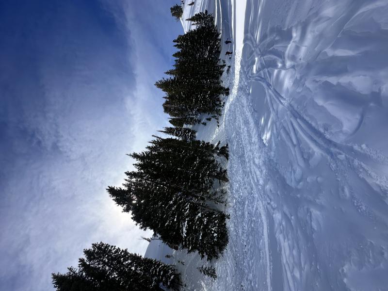
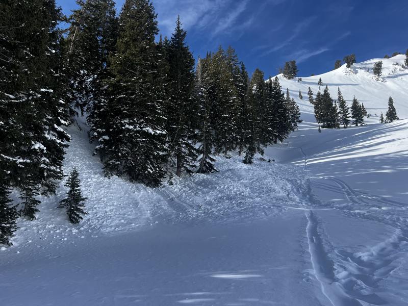
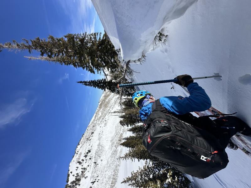
10:17 a.m. – A photo was taken from the ridge by one of the rescue parties prior to skiing, showing the skin track through the trees. See photo below.
10:18–10:19 a.m. – The avalanche occurred. At this time, some members of the rescuing party were near the bottom of the slope in the south-facing portion of Butler Basin, while others were spread across the mid- and upper-elevation terrain. Observers noticed the debris pile and shaking trees and began adjusting their travel to move safely toward the avalanche site. Skins were put on as needed for uphill or traversing travel.
10:20 a.m. – One rescuer who witnessed the avalanche called Alta Central dispatch to report the avalanche and request assistance.
10:25 a.m. – The first rescuer arrived at the debris and, immediately upon arrival, conducted a beacon search, revealing two separate signals. Following the first signal, the rescuer performed a fine search along the top of the debris. During this fine search, the rescuer observed a splitboard binding. After confirming it was attached, the rescuer began shoveling to extricate Skier B.
10:26 a.m. – Additional rescuers arrived at the debris and located Skier B approximately eight minutes after the avalanche, buried roughly 110 cm deep, face up, with their feet above their head. Their airway was exposed and partially obstructed by snow; the rescuers cleared the airway, allowing them to breathe and regain consciousness. They sustained a leg injury from striking a tree and were moved to a safer area on the debris, provided with an emergency blanket, warm clothing, and fluids.
10:27 a.m. – While others attended to Skier B, one rescuer began searching for Skier A using an avalanche transceiver.
10:29 a.m. – During the fine search, the snow caved slightly underfoot, exposing the boot of Skier A. This skier was buried approximately 150 cm, face down with their feet above their head, and skis still attached. The rescuer reached the skier’s location while others assisted with debris management.
10:31–10:32 a.m. – Rescuers exposed Skier A’s airway approximately 12–13 minutes after the avalanche. Multiple rescuers immediately began CPR while additional personnel assisted on site.
10:35–10:37 a.m. – A rescuer provided an update to Alta Central dispatch/911, coordinating additional rescue resources.
11:00 a.m. – Skier B, previously stabilized, was moved into a sunny area for further warming and monitoring.
11:50 a.m. – A medical helicopter circled the site twice but did not land due to the risk of additional avalanches on the slope.
12:10–12:15 p.m. – Skier A was extricated via longline by a Utah Department of Public Safety helicopter. An EMT was longlined in to assist Skier B, who was subsequently airlifted from the scene. CPR continued for Skier A throughout the extrication, while Skier B remained stable.
Both individuals were located using avalanche transceivers, fine search techniques, and shovels. In both cases, probes were not required to pinpoint their locations.
Photo showing skin-track in the trees ascending towards the ridgeline prior to the accident at approximately 10:17 am..
Terrain above from the helicopter showing both burial sites.
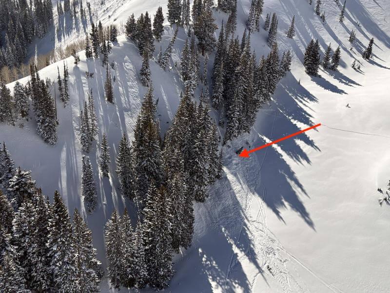
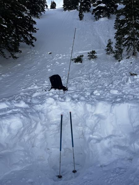
Image showing the lower hole (Skier A).
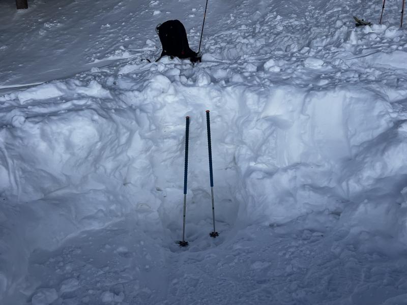
Image showing the upper hole (Skier B).
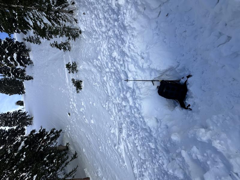
Image showing both the lower hole and the upper hole (Skier A & B burial) from below.
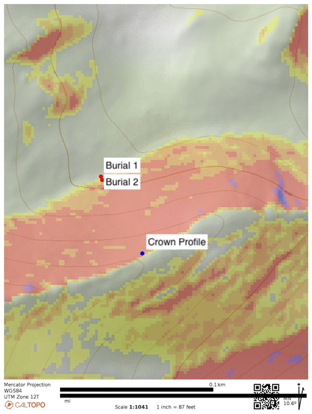
Caltopo map image showing the crown profile and the two burial sites.
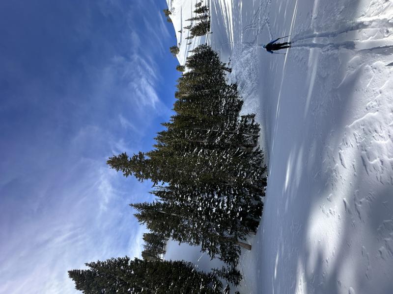
Additional photos of the avalanche and the debris from below.
Terrain Summary
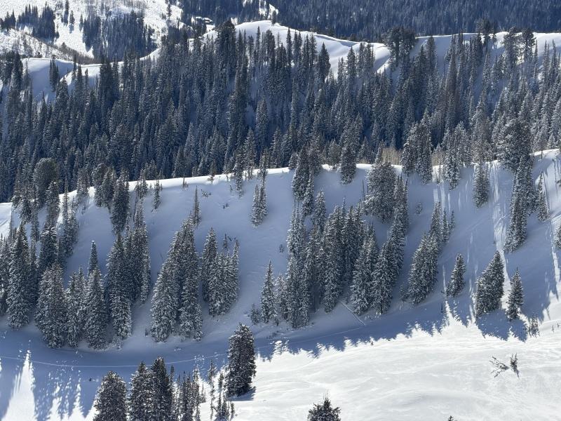
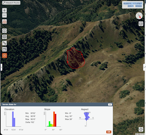
The avalanche occurred on a north-facing slope in Butler Basin in Big Cottonwood Canyon within the Uinta Wasatch Cache National Forest. The slope was a 38-degree sub ridge leading toward Gobblers Knob and held large trees.
The crown was located at approximately 9,300 feet in elevation. The avalanche was approximately 275 feet wide and one to two feet deep. It ran roughly 100 vertical feet before abruptly stopping on a flat bench at approximately 9,200 feet.
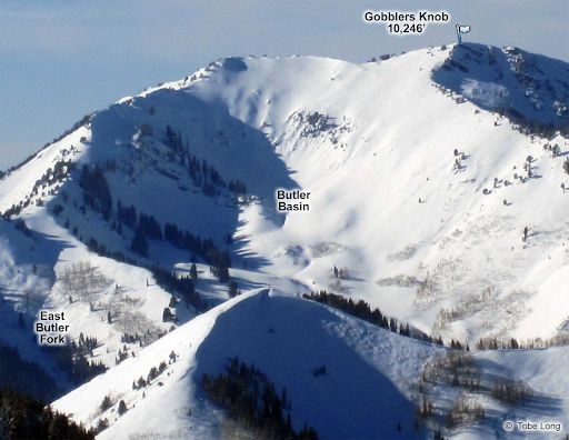
Butler Basin from Wasatch Backcountry Skiing Book.
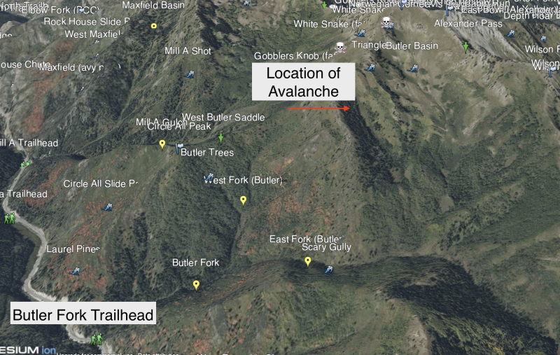
Overview of terrain on Wasatch Backcountry Skiing Map desktop version- with location of avalanche highlighted.
Below is an overview of the slide path and debris. The red shapes depict the initial rider-triggered avalanche.
Weather Conditions and History
In the weeks leading up to the accident, Utah was experiencing one of its driest winters on record. Snow cover was shallow and largely limited to north-facing upper- and mid-elevation terrain. An early January storm delivered 18–24 inches of snow, with about 1.25 inches of snow water equivalent (SWE), across the area. After that, the skies remained clear for several weeks. During this prolonged dry spell, the surface snow became weak and faceted, creating a fragile snowpack structure. On February 11–12, the Central Wasatch received about 10 -12 inches of snow with 1 inch of SWE. While this improved riding conditions, it also highlighted just how unstable the snowpack had become, with numerous human-triggered and remotely triggered avalanches reported.
Beginning Monday, February 16, the Utah Avalanche Center issued an Avalanche Watch ahead of a series of powerful storms forecasted to impact the state. The Avalanche Watch remained in effect through February 17. On February 18, the UAC escalated to an Avalanche Warning for very dangerous backcountry conditions, urging people to avoid avalanche terrain. The storm cycle was significant. By Wednesday, the storm peaked, and the mountains had received approximately 2 feet of snow, with 2 inches of SWE. Winds blowing from the south and west were strong in the days before the accident, with gusts reaching 40 mph.
The Avalanche WARNING and HIGH danger persisted as storm totals approached 31” (2.55” H2O) at the Spruces weather station. Avalanche activity was widespread and too numerous to count throughout Friday. A brief break in the weather was followed by another system in the evening, adding an additional 0.5” of snow (0.02” H2O) before clearing into Saturday.
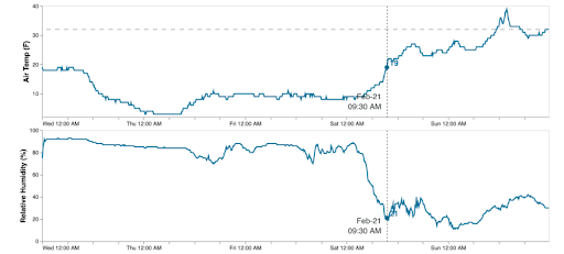
Temperature Data:
Temperature run and average air temperature from Reynolds Peak (9,400’) from February 18 through February 22, 2026. Approximately 1.66 miles due east from the site of the avalanche.
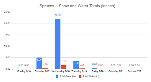
Snow Data:
Snow and water totals for the storm cycle from February 16 through February 22 measured at Spruces, approximately 2.83 miles due east of the site of this avalanche.
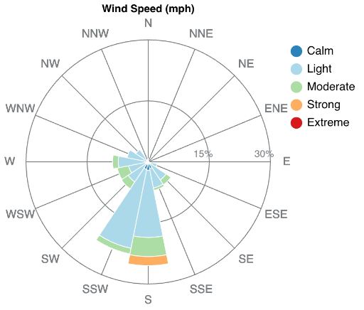
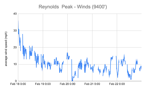
Wind Data:
Wind Rose and average speeds from Reynolds Peak (9,400’). The graphs show wind direction, distribution, and speeds from February 18 through February 22.
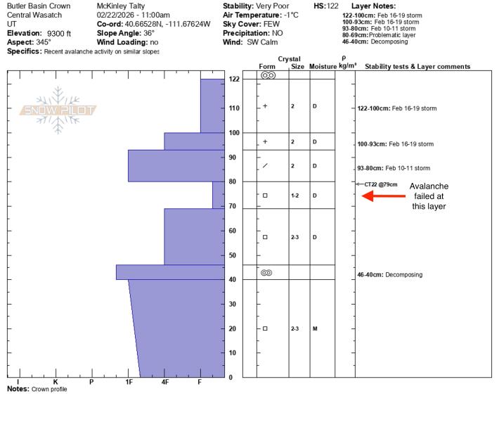
Snow Profile Comments
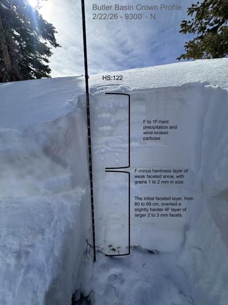
The crown was located at 9,300 feet on a north/northwest aspect directly off a subridge. At the crown profile location, the slope angle measured 36 degrees, consistent with the surrounding slope, which averaged 38 degrees. Crown depths averaged one to two feet. The slab consisted of F to 1F-hard precipitation and wind-broken particles within the upper 42 cm of the snowpack. From 122 to 93 cms, the snowpack was composed of very hard 2 mm precipitation particles from the February 16 to 19 storm. Between 93 and 80 cm, the snow consisted of 2 mm wind-broken particles.
The slab rested on an F-minus hardness layer of weak faceted snow, with grains 1 to 2 mm in size. This initial faceted layer, from 80 to 69 cm, overlaid a slightly harder 4F layer of larger 2 to 3 mm facets. The decomposing Christmas Eve rain crust was present between 46 and 40 cm, with 2 to 3 mm moist facets extending to the ground below the crust.
The primary failure plane appeared to be within the F-minus faceted layer between 80 and 69 cm, though in some areas the avalanche stepped down into the deeper faceted layer between 69 and 46 cm.
The terrain was unforgiving, with the steep slope ending abruptly in a flat area at the bottom, where the debris accumulated deeply.
Snowpilot crown profile at 9300'.
Annotated crown profile performed on 2/22/2026.
Additional photo of crown from mid-slope showing average depth of 1-2 feet.
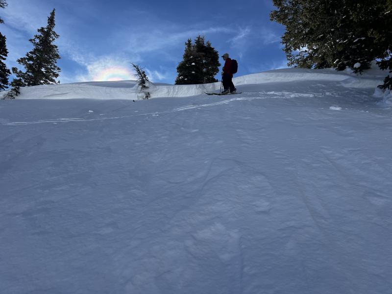
Photo of the crown before the crown profile was performed.
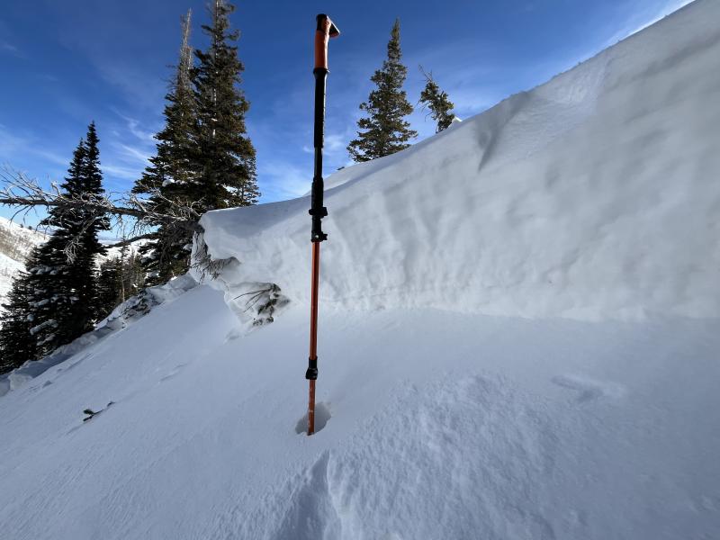
Varying crown depth.
Comments
Decision Making
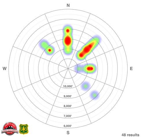
The avalanche danger for this location was rated as CONSIDERABLE for the Salt Lake area mountains on the day of this accident. In addition, the Utah Avalanche Center had issued a Special Avalanche Bulletin for the weekend to highlight the dangerous avalanche conditions where human-triggered avalanches were considered likely. By the evening of February 20, there had been 48 avalanches, including two avalanche fatalities, reported to the Utah Avalanche Center in the Salt Lake Area Mountains since February 16.
In communication with Skier B, they indicated that both skiers had read the avalanche forecast for the day and had decided to stick to slopes less than 30 degrees, given the Considerable avalanche danger rating and recent accidents. When they entered the Butler Basin drainage, both skiers expressed concern about the steep, north-facing terrain but felt the trees would offer some safety as they navigated the slope toward the ridgeline.
Attached is the avalanche heat map for the Salt Lake Area Mountains, February 16 through the night of February 20.
Additional Comments
At the Utah Avalanche Center, we strive to learn from every avalanche accident and share insights to help others avoid similar accidents. We have all experienced close calls and understand how easily mistakes can happen. Our goal with this report is to provide a valuable learning opportunity. With that in mind, we offer the following comments.
Key takeaways from this event:
Respect the Danger: A CONSIDERABLE avalanche danger with persistent weak layers is serious. In one multi‑decade review, CONSIDERABLE danger days accounted for roughly 45 % of recorded avalanche fatalities, more than any other danger level in that dataset. Roughly 70% of all avalanche fatalities involve PWLs (persistent weak layers).
Terrain Management: Even slopes that appear more benign, or areas “protected” by trees, can still slide. Trees and terrain features are not fail-safes.
Read and Apply the Forecast: Public backcountry avalanche forecasts issued by the Utah Avalanche Center provide a danger rating with respect to aspect and elevation. Follow guidance provided by the avalanche forecast when considering travel plans in avalanche terrain.
Communication Matters: If something feels unsafe, speak up. Others around you may be feeling the same uncertainty, and saying something could prevent an accident.
Stick to the Plan: Don’t drift from your intended route into more dangerous terrain. Deviating from your plan increases exposure to hazards and risks that weren’t initially planned for within the day.
Stay Objective: Powder enthusiasm can cloud judgment. Enjoying fresh snow is part of the sport, but it should never override careful decision-making.
Control Exposure: Expose only one person at a time in avalanche terrain. This reduces the risk to multiple people and makes rescue simpler if something does go wrong. While this is more difficult during uphill travel, we should note that a significant number of accidents and close calls involve skiers or riders traveling or skinning in uphill mode.
Accidents are always a reminder to go back to the basics and be deliberate in the backcountry.
We aim to learn from accidents like this and in no way intend to point fingers at victims. Thank you to all the members of the community who participated in this rescue. Our deepest heartfelt condolences go out to the family, friends, rescuers, and everyone affected by this tragic accident.
Coordinates


