Forecast for the Uintas Area Mountains

Paige Pagnucco
Issued by Paige Pagnucco on
Friday morning, March 13, 2026

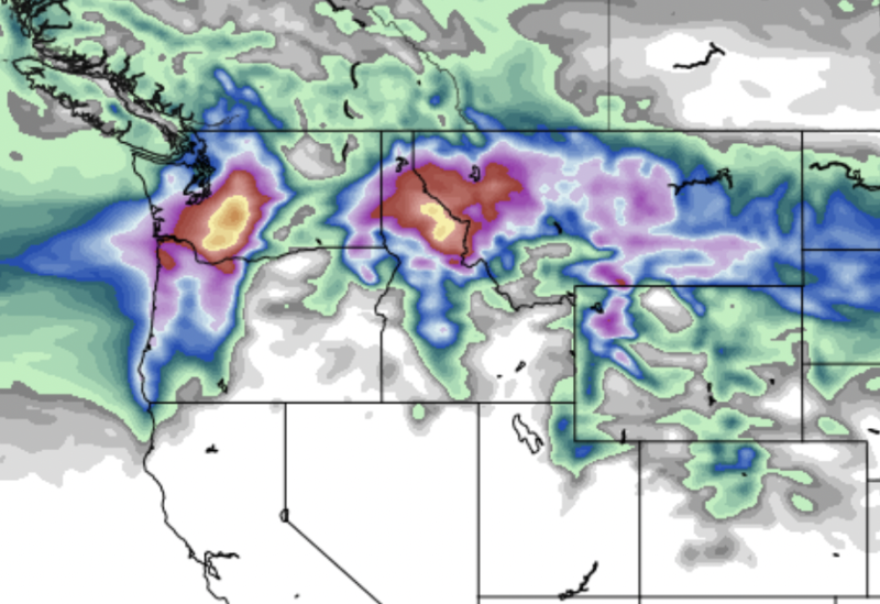
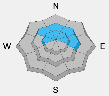
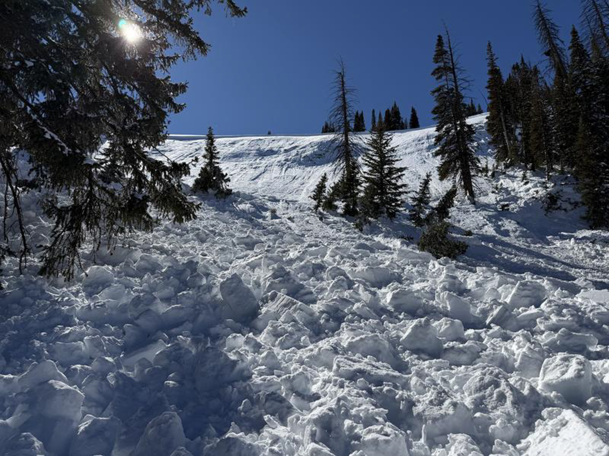
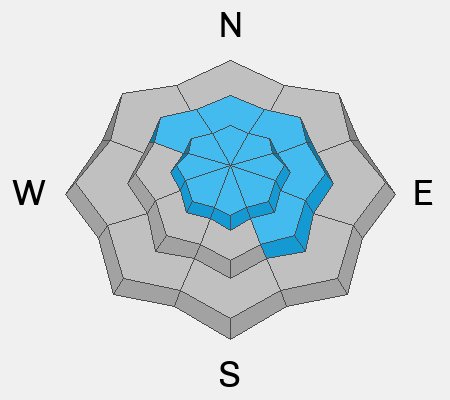
Heightened avalanche conditions exist. It remains very possible to trigger a dangerous hard slab avalanche failing on a buried persistent weak layer of faceted snow. This problem is most concerning on mid and upper-elevation slopes facing the north half of the compass, especially in steep, rocky terrain where the snowpack is thinner. Any avalanche that breaks down to the facets could be large and destructive.

Winds will continue to drift snow into steep leeward terrain, forming hard and soft slabs that may be sensitive to a rider's weight.

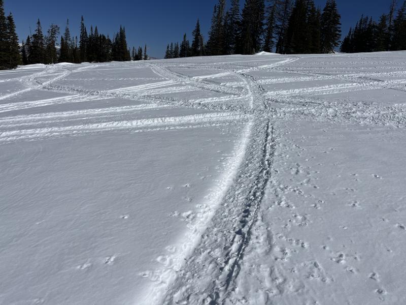
Evaluate snow and terrain very carefully and follow safe travel protocols - expose only one person at a time in avalanche terrain.

Low
Moderate
Considerable
High
Extreme
Learn how to read the forecast here
Weather and Snow

Areas of soft snow exist, but you’ll have to gain some elevation to find them. Low-angle, upper-elevation, sheltered, and shady northerly terrain is your best option for finding winter-like conditions (not connected to or near steep slopes). The sun and wind have done some damage to the surface in exposed low and mid-elevation terrain over the past week, creating a variety of crusts. The snow surface is supportable most everywhere, though take caution when crossing low- and mid-elevation snow bridges over creeks, as they are beginning to soften and lose integrity.

This morning, 10,000-foot temps are a bit warmer, around 30°F, and winds are blowing from the west at around 20 mph, with gusts in the 30s and even up to 40-50 mph along the most exposed ridgelines. Expect a nice day with temperatures reaching 35°F at 10,000' and winds blowing from the west-northwest 20 to 25 mph with gusts close to 40 mph. Wind chills will be in the single digits F.

A quick-hitting storm rolls through the Uintas tomorrow, promising strong winds, a few inches of snow, and thunder!

Saturday's storm is really a brush-by with the main energy staying well to our north. Fingers are crossed for the high end of forecasted amounts.

Snow surface near Wolf Creek is supportable but very rough and firm.

Recent Avalanches

No avalanches were reported yesterday, Find all Uintas observations HERE.

Avalanche Problem #1
Persistent Weak Layer
Type
Location
Likelihood
Size
Description

The snowpack is complex, with weak, sugary faceted snow from January sitting underneath multiple feet of denser snow. Strong snow over weak snow is a classic setup for avalanches. Obvious red flags like collapsing and cracking may be absent, and you may even get a few sets of tracks on the slope before finding the right trigger spot, often a shallower part of the slab near rocks or bushes. High marking comes to mind as a possible way to trigger this type of large and destructive avalanche.

While not widespread, this problem is impossible to navigate. The only sure way to deal with a persistent weak layer is to avoid it - steep and rocky slopes with shallow snow on the north half of the compass are off limits for now.

The slide on Duchesne Ridge produced SUV-size chunks of debris, which stacked up deep in the runout and in the trees below. Getting caught in a dangerous slide like this could be game over -- Trees turn into baseball bats, and debris chunks are like boulders coming down on you.

Avalanche Problem #2
Wind Drifted Snow
Type
Location
Likelihood
Size
Description

With continued windy conditions, expect shallow, sensitive slabs of wind-drifted snow to develop in leeward terrain and around terrain features such as gullies, rock outcrops, sub-ridges, and mid-slope rollovers. These smooth, rounded pillows may feel hollow underfoot and let you get well out onto them before suddenly releasing. Cracking and collapsing may not be present. Remember, any avalanche triggered can step down into buried weak layers within the snowpack, triggering a larger avalanche than expected.

It's easy to avoid this problem by staying out of the wind zone and not traveling on steep slopes holding rounded, textured pillows of snow.

Textured snow surfaces mean the wind has been busy, scouring windward slopes and moving snow onto leeward slopes.

Additional Information
Our Avalanche Rescue Training Park is set-up and located at the top of Wolf Creek Pass, SR-35, and is waiting for you to come take it for a spin! Open up the control unit, flip a few switches, and dial in your avalanche rescue skills with this roadside attraction!
More details about the WCP Beacon Park, here!

General Announcements

We have some upcoming classes and events that we'd be stoked to see you at -- Please reach out with any questions and check out below for more details!

We are always looking for snow and avalanche observations or just general riding conditions. Reach out to us with questions, concerns, or if you see anything in your travels! Contact us directly through the info below:

This forecast is from the U.S.D.A. Forest Service, which is solely responsible for its content. This forecast describes general avalanche conditions, and local variations always occur. This forecast was issued on Friday, March 13, at 7:00 AM and expires 24 hours after it was issued. We'll update this information by about 7:30 AM tomorrow.