Forecast for the Uintas Area Mountains

Andrew Nassetta
Issued by Andrew Nassetta on
Tuesday morning, March 10, 2026

MODERATE avalanche danger exists in mid and upper elevation terrain on steep, rocky and complex slopes facing northwest through east where human-triggered avalanches are POSSIBLE. Remember, today's slides can still be triggered remotely, failing multiple feet deep into faceted snow from the dry January spell.

Although the likelihood of triggering an avalanche into old, faceted snow is going down, the consequences remain severe if we do. I can not outsmart this problem, so avoidance is my only tool for this dragon.

Low
Moderate
Considerable
High
Extreme
Learn how to read the forecast here
Weather and Snow

Nowcast - Broken skies and a few stars kick off the morning with warmer than average temperatures and gusty winds. Trailheads report in the upper 30's°F while upper elevation stations near 11,000' are hovering around 25°F. Moderate to strong winds blow from the southwest, and have for the past five hours, averaging 30 MPH gusting into the high 40's.

Forecast - Things cool off today, and the high should be about ten degrees cooler than yesterday, topping out in the mid-30's°F. Westerly winds persist, and increase as a cold front cruises through the range later today, with winds averaging 40-50 MPH along with it.

Futurecast - Temperatures chill out over the next few days, with gusty winds and sunny skies overhead. Theres no sign of a refresh in the near future, but we'll keep you in the loop if anything shakes for the long-run.

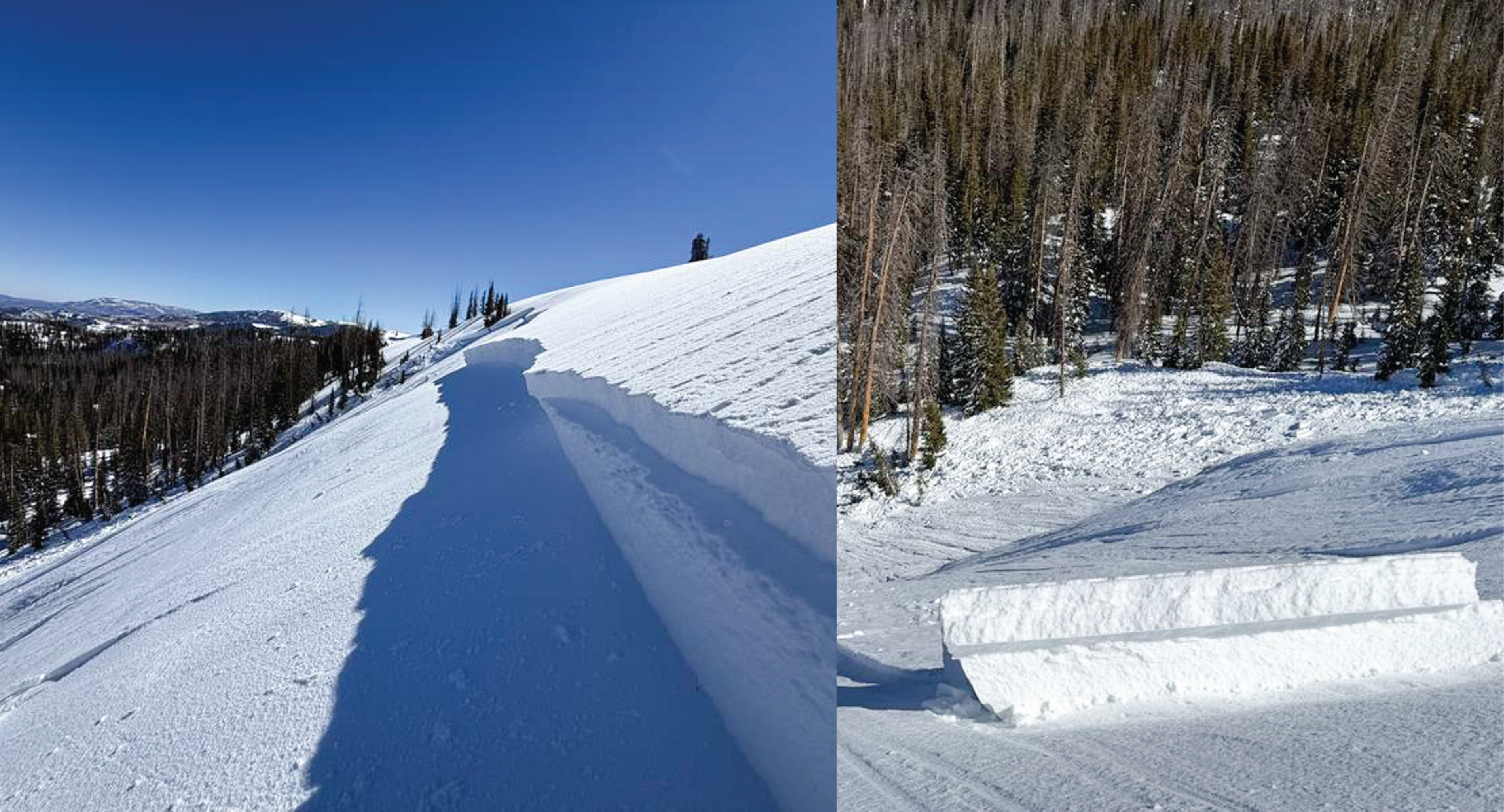
Travel Conditions - Once again, it is quickly beginning to look like spring out there. We have 5-10" of settled snow on protected, upper elevation polars from last weeks storm that is riding well. Solar aspects and windward terrain are cooked and wind scoured leaving behind a mixed back of textured surfaces, crusts, wind-board and wind-pack in exposed areas. Get out of the. mud, and gain some elevation where you will find decent coverage all around for travel with the best riding in cold, sheltered terrain on the north side of the compass.

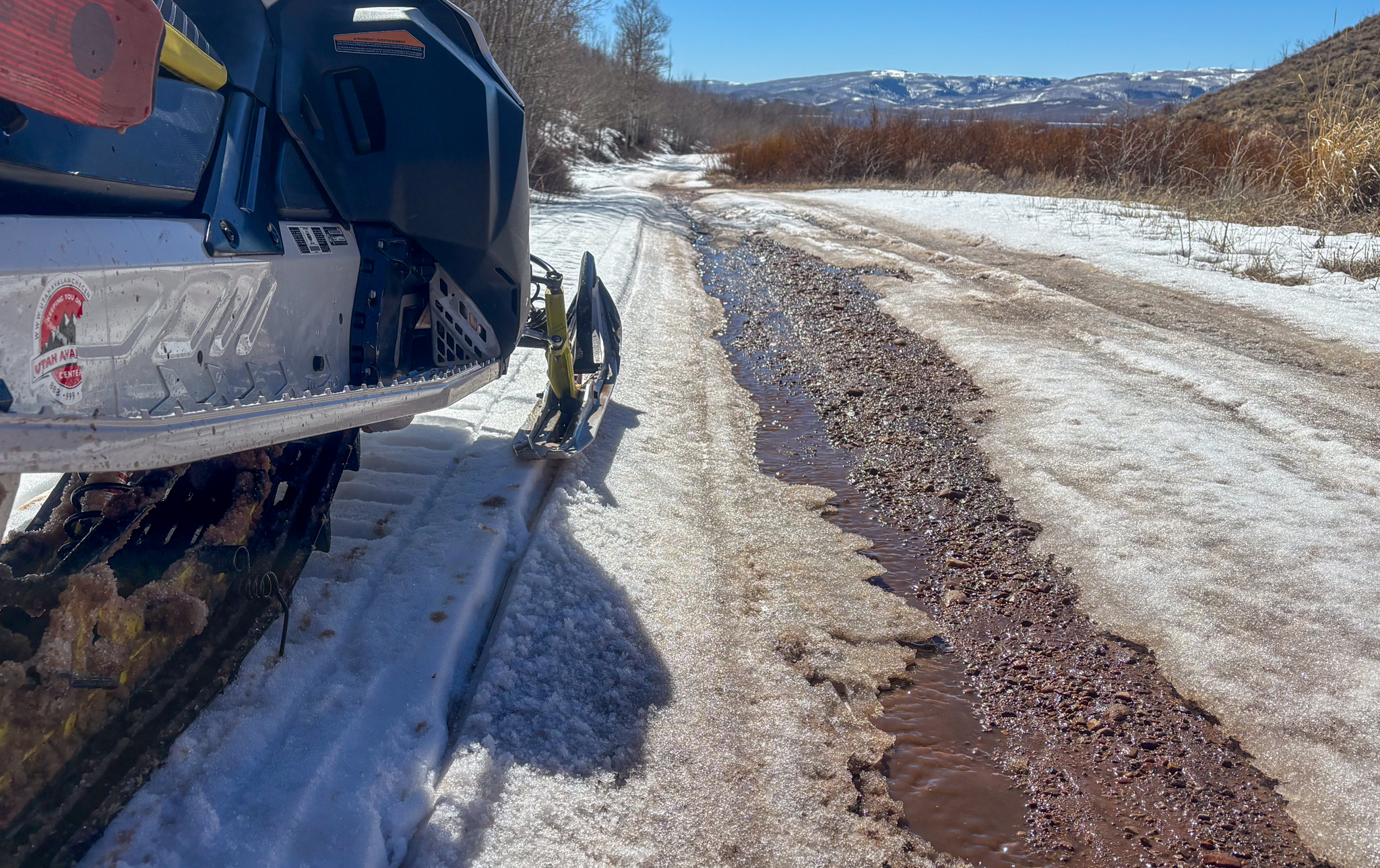
A cool down can't save us now! Access is becoming challenging from many of our trailheads and I think we are getting close to the end of it, for tracked vehicles that is.

Recent Avalanches

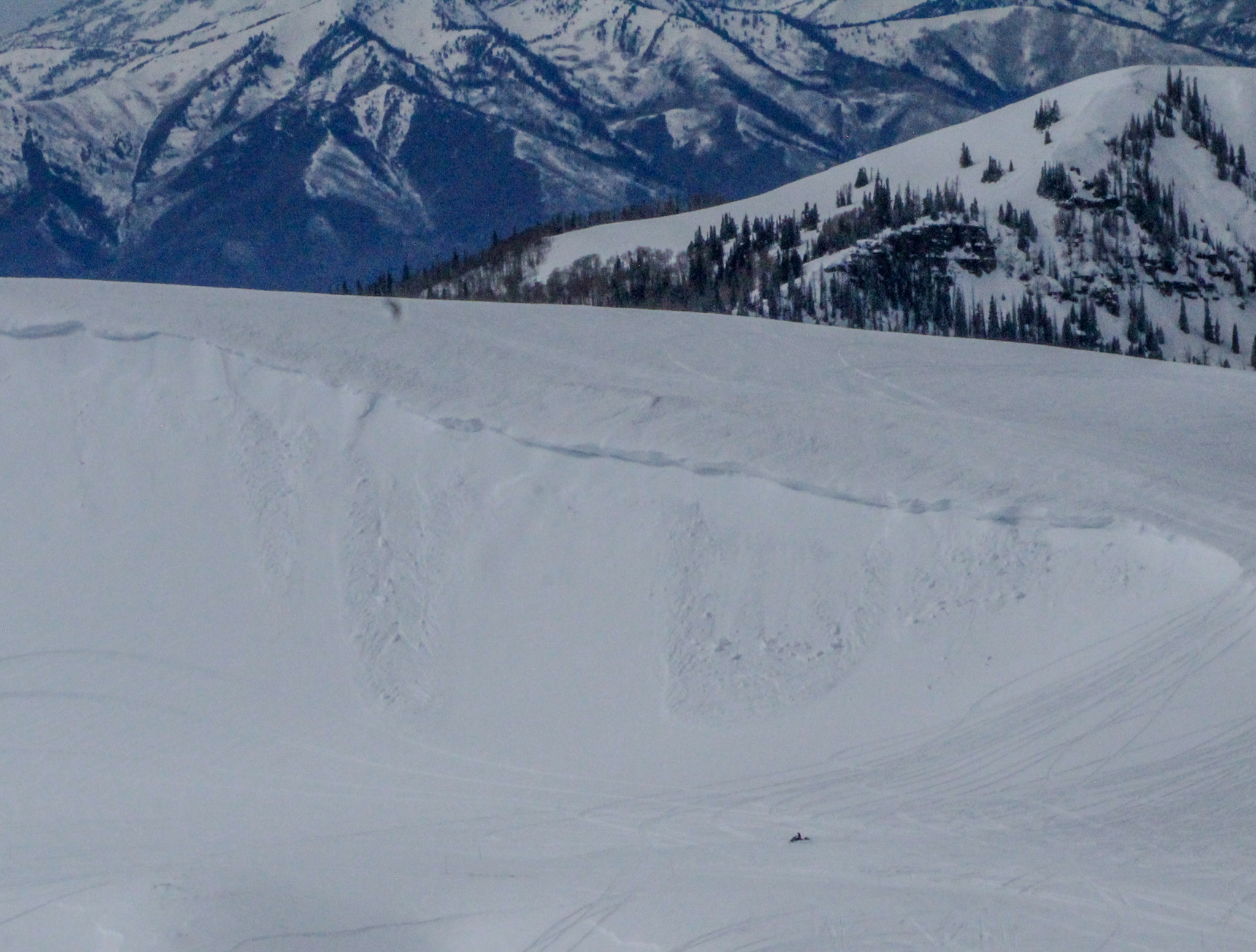
Sunday afternoon on Duchesne Ridge , an all-star crew remotely triggered this meaty slab from a the ridge on a mid-elevation, northeast, steep and rocky slope. It failied up to 3' deep into faceted snow from January, breaking nearly 700' wide-- You can read more from their excellent write-up found, here.

Large avalanches that are being remotely triggered are not to be overlooked, and are a significant red flag pointing to our current hazard, reminding us that our faceted snow is still weak and reactive in places.

Avalanche Problem #1
Persistent Weak Layer
Type
Location
Likelihood
Size
Description

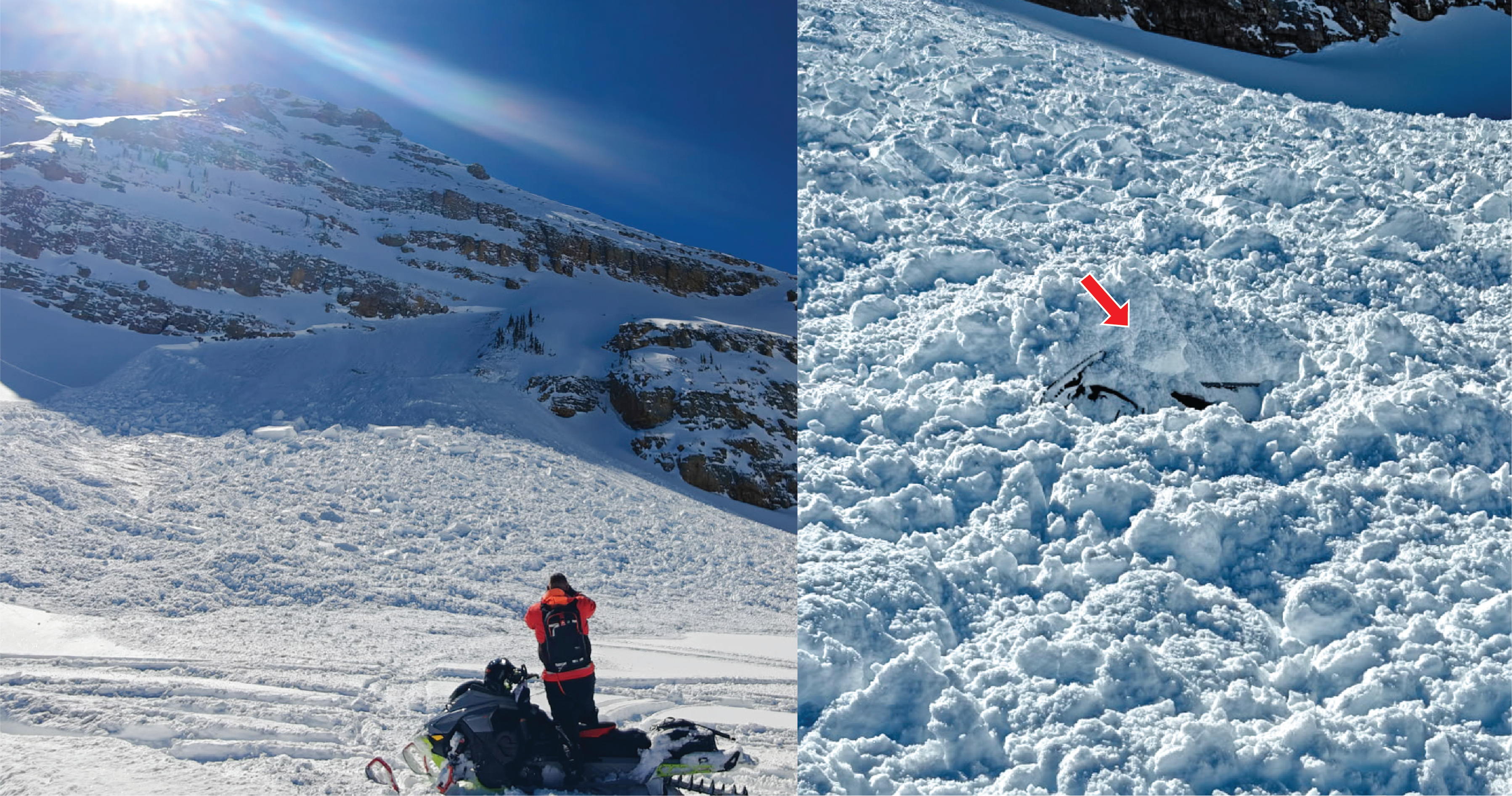
Sunday's close call is a firm reminder that it is still winter in the high-country, and although the chances of triggering a big slide are still possible. These riders got lucky with only one of their rigs getting buried -- Thanks to Jake and his crew for sharing their first-hand report for all of use to learn from, check it out here.

It's straight up tricky out there, and heres why. Our persistent weak layer is becoming more stubborn by the day, but continues to produce avalanches. That being said, the likelihood of triggering this avalanche problem is going down -- This is the good news. On the flip side, we are not out of the woods yet and poor structure exists in isolated mid and upper elevation terrain where a 2-4' slab overlays weak and sugary faceted snow from the Dry January Spell. We can trench multiple sets of tracks on a slope without incident, but all we need to do is find a weakness where the slab and weak layer are susceptible to our additional weight as a rider, maybe around a rock or a bush, collapse the pack, and now we have triggered an avalanche big enough to ruin our day.

My go-to and only tool for this set-up is avoidance. Steep, rocky, shallow slopes on the north half of the compass that are complex and have a lot going on are still off the table -- I can not outsmart this problem, so avoidance is my go-to tool for this dragon.

Above are a few other angles of the slide on Duchesne Ridge that produced SUV-size chunks of debris stacking up deep in the runout and trees below. Getting caught up in a slide like this could potentially be game over -- Trees turn to baseball bats, and debris chunks like boulders coming down on top of you.

Avalanche Problem #2
Wind Drifted Snow
Type
Location
Likelihood
Size
Description

Winds blowing from the southwest averaging 30 MPH load leeward slopes on the east half of the compass at upper elevations, today. There is not a ton of snow left to move around, expect today's drifts to be mall in size and stubborn. Remember, any avalanche triggered can step-down into buried weak layers within the snowpack, triggering a larger avalanche than we signed-up for.

Fortunately, this is a very manageable avalanche dragon to identify and an equally easy one to avoid. Simply steer clear and avoid fat, rounded pillows of snow, especially if they look textured and feel hollow.

On Tower mountain, small natural wind-drifts paint a good picture of what today's will look like -- Remember, even a small slide raking you over some rocks or into trees good have a severe outcome.

Additional Information

Join the UAC for the first at Bear River Lodge in the Uintas, March 19th-22nd. This course is designed for snowmobilers by snowmobilers, where you will learn avalanche rescue, riding skills, and how to survive in the backcountry. Come enjoy all the luxury offerings at Bear River Lodge and improve your skills along the way.

Our Avalanche Rescue Training Park is set-up and located at the top of Wolf Creek Pass, SR-35, and is waiting for you to come take it for a spin! Open up the control unit, flip a few switches, and dial in your avalanche rescue skills with this roadside attraction!

More details about the WCP Beacon Park, here!

General Announcements

We have some upcoming classes and events that we'd be stoked to see you at -- Please reach out with any questions and check out below for more details!

We are always looking for snow and avalanche observations or just general riding conditions. Reach out to us with questions, concerns, or if you see anything in your travels! Contact us directly through the info below:

This forecast is from the U.S.D.A. Forest Service, which is solely responsible for its content. This forecast describes general avalanche conditions, and local variations always occur. This forecast was issued on Tuesday, March 10 at 0600 and expires 24 hours after it was issued. We'll update this information by 07:00 AM tomorrow.