Forecast for the Uintas Area Mountains

Craig Gordon
Issued by Craig Gordon on
Thursday morning, February 5, 2026

A sea of green blankets the danger rose, suggesting LOW avalanche hazard and a c'mon in... let's party, kinda mindset. However, don't remove this tag, because there's a disclaimer here- LOW avy danger doesn't mean NO avy danger-

Even though human triggered avalanches are UNLIKELY, as I stretch my wings and think of bigger terrain objectives, I continually gather information, and avoid slopes and terrain features in the windzone that look rounded, pillowed, or sound hollow like a drum.

Low
Moderate
Considerable
High
Extreme
Learn how to read the forecast here
Weather and Snow

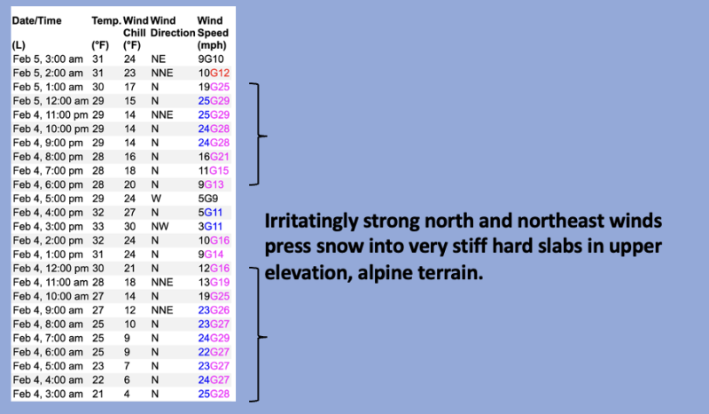
Nowcast - Firmly entrenched high pressure over the region delivers nuthin' but clear skies and balmy temperatures which begin the day in the upper 20's °F across the board. Near the high peaks, buzz-killing, snow torching winds blow 25-30 mph from the north and northeast.

Forecast - We can expect yet another dry, mild day with high temperatures climbing into the mid 40's °F. Winds blowing from the north and northeast are gonna be obnoxious this morning, but taper off right around sunrise.

Futurecast - Rinse and repeat through the weekend, but then there's a hint of a pattern change for more active weather slated to arrive late Monday or Tuesday. Too early to tell timing and strength for storminess. The encouraging news is winter is returning from its tropical hiatus. Man, I hope it's well rested and ready to party!

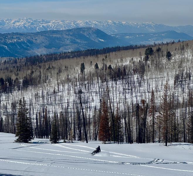
Travel Conditions - This winter looks underwhelming from first sight, but the Uinta's are performing closer to average this season than meets the eye. Snow depths vary from 1-3' across the range above 9,000' with a mostly right-side up snowpack. In general, protected polars continue to weaken but are riding well thanks to our Christmas Eve rain crust keeping us off the ground. Flip the compass script to slopes exposed to the elements for the past couple weeks, and they display a combo of wind-press, jack and whack, whilst lacking any attractive riding quality.

Avy savvy, snowpros, and all around remarkable people, Dave and Johanna Kelly took their steel horses for a ride in the Soapstone zone yesterday and report a fine day of riding in brilliant sunshine.

Tuesday, Ted and I staged out of Smith-Moorehouse to gain access to the North Slope.... all the deets on our travels are found HERE.

Recent Avalanches

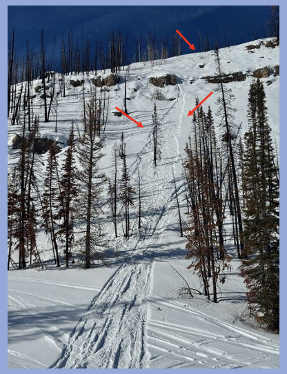
The surface snow continues to grow weaker by the day and once initiated, small, loose snow sluffs are entraining more snow than you might expect... as illustrated by the image above. A minor threat now, but speaks to a potentially tricky setup once winter decides to start wintering again.

Avalanche Problem #1
Persistent Weak Layer
Type
Location
Likelihood
Size
Description

Above is a 24 hour data dump from Lofty Lake Peak (11,186') illustrating several periods of snow torching, wind pressing velocities and duration.

Consistent, yet variable winds have welded stiff, hard slabs in place and that'll feel solid under our ride, but the problem is... this setup rests above a sugary layer of faceted snow that formed during the recent stretch of high pressure. We forget about weak layers, but the snowpack has a great memory. (Learn more about it here, and why it's important to pay attention to surface conditions.)

Above treeline, on steep, wind-loaded slopes, specifically those with with an easterly component, hardened slabs living above faceted snow (persistent weak layer) are cracking, collapsing, and reacting to our additional weight. While the chances of triggering this avalanche problem are decreasing, if you're getting after it on sustained, steep terrain in the alpine, remember even a small slide in consequential terrain could turn nasty if it strains us through trees, rocks, or over cliffs.

Fortunately, we can avoid this problem by seeking wind sheltered terrain out of the alpine where we're greeted with more straight-forward avalanche danger and protected, cold, recycled powder.

General Announcements

We have some upcoming classes and events that we'd be stoked to see you at -- Please reach out with any questions and check out below for more details!

We are always looking for snow and avalanche observations or just general riding conditions. Reach out to us with questions, concerns, or if you see anything in your travels! Contact us directly through the info below:

This forecast is from the U.S.D.A. Forest Service, which is solely responsible for its content. This forecast describes general avalanche conditions, and local variations always occur. This forecast was issued on Thursday, February 5th at 0300 AM and expires 24 hours after it was issued. We'll update this information by 07:00 AM tomorrow