Forecast for the Uintas Area Mountains

Craig Gordon
Issued by Craig Gordon on
Saturday morning, February 28, 2026

Make no mistake... we've got a tricky snowpack and it's deceptively dangerous-

CONSIDERABLE avalanche danger is found in mid and upper elevation wind sheltered, polar terrain, which offers a strong feeling, dense, Maritime-esque slab resting atop very weak January snow... a dangerous setup for us. This combo feels solid underfoot, but all we need to do is collapse the slope, knock the legs out from underneath, and now we're staring down the barrel of a dangerous avalanche. Breaking 2'-4' deep and a couple football fields wide, human triggered, tree snapping avalanches are LIKELY in terrain with these snowpack characteristics.

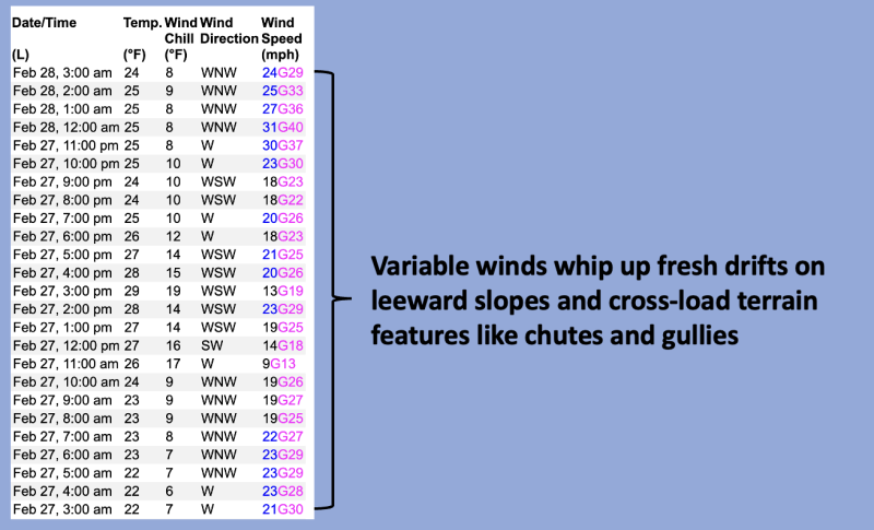
On the other side of the compass and more straight-forward, MODERATE avalanche danger exists mostly on steep, upper elevation, solar slopes where fresh drifts react to our additional weight and human triggered avalanches are POSSIBLE

Low
Moderate
Considerable
High
Extreme
Learn how to read the forecast here
Weather and Snow

Nowcast - Near the high peaks, winds blow from the west in the 30 mph range, ushering in a band of high, thin clouds, while temperatures begin the day in the upper 20's °F.

Forecast - Another warm, spring-like day is on tap, with high temperatures climbing into the mid 40's °F. Clouds increase as the day progresses and we might see a stray snow shower or two by about dinnertime. Winds don't vary much from where we're at this morning.

Futurecast - The graybird takes flight Sunday, opening the door to storminess beginning the workweek.

Travel Conditions -

Riding and turning conditions have taken a hard hit and I've gotta be honest with ya... it's a bit rugged out of the gates. However, gain some elevation and the high country delivers a styrofoam-like, surfy, snow surface that's worth the struggle... type 2 fun :)

Recent Avalanches

Thursday afternoons avalanche activity was sort of the thing... still cataloging the cleanup on aisle 5 and around Moffit Peak where natural avalanches broke deep and wide. It fits the mold of a curious, afternoon, natural avalanche cycle in protected terrain with a very weak snowpack, perhaps getting it's first dose of heat... an 8-10 degree bump from the morning low temperatures. Ted and I have been tracking this slope and observed the very weak foundation developing back on January 20th. More deets found here.

Click below for all the news that fits-

Avalanche Problem #1
Persistent Weak Layer
Type
Location
Likelihood
Size
Description

Ted and I caught this piece of snow in the far western reaches of the North Slope, most likely avalanching naturally early Thursday morning. Breaking deep and wide and failing on the January drought layer, this is exactly the type of avalanche dragon we're dealing with again today.

Andy Nassetta nailed it a few days ago... "We've got a dense Maritime-esque slab resting on weak, Continental facets." Indeed... a different type of strong snow on top of weak snow structure and very unusual for us. In fact, recent avalanche activity confirms this notion. And while I suspect we've rounded the corner for natural avalanche activity, I bet there's many slopes that wait for a trigger like us to roll along and knock the legs out from underneath.

So, here's the deal... from tip to tail, polar aspects at all elevations, harbor our most recent problem child, the well preserved and aptly named January Drought Layer (JDL). This faceted snow is extremely weak, and teeters on the edge with last weeks colossal storm... 2'-3' of snow and up to 3" of SWE, and now Tuesday night's additional shot of snow, water, and wind. The rubber band might not be as tightly stretched as it was a few days ago, but once it gets snapped, it's game on.

Avalanche Problem #2
Wind Drifted Snow
Type
Location
Likelihood
Size
Description

A 24 hour data dump from Windy Peak (10,661') illustrating wind direction and velocity.

Recent winds have been all over the map and I bet there's a fresh drift or two that'll react to our additional weight. Isolated to leeward terrain in the wind zone, today's wind slabs are a manageable avalanche dragon and easy to avoid. Simply steer clear of steep, drifted slopes and pieces of snow that are fat and rounded, or sound hollow like a drum. You've been around long enough and know, when we lose the wind... we lose the problem.

Additional Information

Join the UAC for the first "Stay and Play Avalanche Course" at Bear River Lodge in the Uintas, March 19th-22nd. This course is designed for snowmobilers by snowmobilers, where you will learn avalanche rescue, riding skills, and how to survive in the backcountry. Come enjoy all the luxury offerings at Bear River Lodge and improve your skills along the way.

Our Avalanche Rescue Training Park is set-up and located at the top of Wolf Creek Pass, SR-35, and is waiting for you to come take it for a spin! Open up the control unit, flip a few switches, and dial in your avalanche rescue skills with this roadside attraction!

General Announcements

We have some upcoming classes and events that we'd be stoked to see you at -- Please reach out with any questions and check out below for more details!

We are always looking for snow and avalanche observations or just general riding conditions. Reach out to us with questions, concerns, or if you see anything in your travels! Contact us directly through the info below:

This forecast is from the U.S.D.A. Forest Service, which is solely responsible for its content. This forecast describes general avalanche conditions, and local variations always occur. This forecast was issued on Saturday, February 28th at 0330 and expires 24 hours after it was issued. We'll update this information by 07:00 AM tomorrow.