Forecast for the Uintas Area Mountains

Craig Gordon
Issued by Craig Gordon on
Friday morning, February 27, 2026

Make no mistake, cause it's gonna roll ya... we've got a tricky snowpack and it's deceptively dangerous-

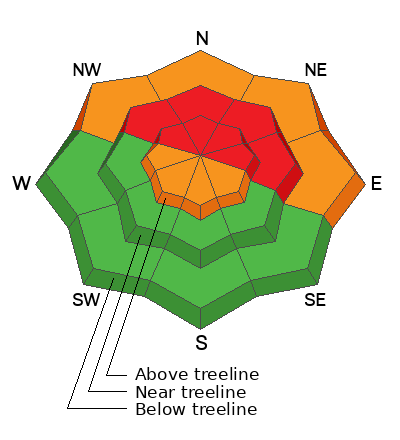
Mid and upper elevation wind sheltered, polar terrain is where a not-so-straight-forward rubber hits the road and you'll find HIGH avy hazard with a different flavor... a slide that could boss us around in terrain we generally feel comfortable riding during times of elevated avalanche danger. Don't forget... a strong, dense, Maritime-esque slab rests on faceted, sugary, Continental snow now buried several feet from the snow surface. That combo will feel solid underfoot, but all we need to do is collapse the slope, knock the legs out from underneath, and now we're staring down the barrel of a dangerous avalanche. Breaking 2'-4' deep and a couple football fields wide, human triggered, tree snapping avalanches are VERY LIKELY in terrain with these snowpack characteristics.

Fresh drifts will react to our additional weight and human triggered avalanches are LIKELY on steep, solar slopes.

Lower elevation polars get in on the act as recent rain on snow and warm overnight temperatures keeps the hazard at CONSIDERABLE. Human triggered damp snow avalanches, gouging into weak snow near the ground are LIKELY on sustained, steep slopes.

Low
Moderate
Considerable
High
Extreme
Learn how to read the forecast here
Weather and Snow

Nowcast - With clear skies overhead, temperatures are somewhat cool, starting the day in the mid 20's °F, with a few trailheads hovering right around freezing. Winds from the west and northwest, blow 25-35 mph near the high peaks. Yesterday's heat hit hard and it's rugged riding out of the gates, but the high country delivers a styrofoam-like, surfy, snow surface that's worth the struggle... if you like that kind of thing :)

Forecast - A warm, spring-like day is on tap with mostly sunny skies and temperatures rising into the low 40's °F. Winds near the high peaks blow in the 40's from the west and northwest.

Futurecast - Increasing clouds late Saturday followed by an active, yet warm pattern for Sunday into next week.

Travel Conditions - After six weeks of teaser snowfall, finally, the Uinta's got absolutely clobbered and last weeks big storm is nothing short of colossal. Riding conditions have gone from April-esque to mid-winter back to April-esque in the span of about 10 days. Low elevation solars are already taking a hit from the sun and heat, but gain some elevation and swing around to the mid and upper elevation polars where it's looking white and the riding is quite bouncy.

The Bear River Trailhead on Wednesday reflects the winter that wasn't... recent rain at lower elevations, an evaporating snowpack, and a whole 'lotta pavement goin' on... dang :(

Recent Avalanches

A keen eye and always looking for recent avalanche activity while trying to keep his rig from coloring too far outside the white lines of the highway, master-snow-crafter Andy Nassetta, caught this slide on the way home from Weber Canyon yesterday. It fits in the mold of a curious, afternoon natural cycle in mid-elevation protected terrain, perhaps getting it's first dose of heat... an 8-10 degree bump from the morning low temperatures.

No shortage of avalanche activity across the range, and the Uinta community sure got after it last weekend. Multiple natural and human-triggered slides were observed and reported, with a few close-calls along the way. Click below for all the news that fits-

Avalanche Problem #1
Persistent Weak Layer
Type
Location
Likelihood
Size
Description

Ted and I caught this piece of snow in the far western reaches of the North Slope, most likely avalanching naturally early Thursday morning. Breaking deep and wide and failing on the January drought layer, this is exactly the type of avalanche dragon we're dealing with again today.

Nailed it! A sub-committee last night with avy-savvy, snow pro and partner in crime (though we are not criminals :) Andy Nassetta accurately stated... "We've got a dense Maritime-esque slab resting on weak, Continental facets." A different type of strong snow on top of weak snow structure and very unusual for us.

So, here's the deal... from tip to tail, polar aspects at all elevations, harbor our most recent problem child, the well preserved and aptly named January Drought Layer (JDL). This faceted snow is extremely weak, and teeters on the edge with last weeks colossal storm... 2'-3' of snow and up to 3" of SWE, and now Tuesday night's additional shot of snow, water, and wind. The rubber band is tightly stretched once again.

Bringing it full circle, when I think of bullseye terrain where I could trigger a dangerous slide today I'm thinking low on the slope where several football fields worth of snow hangs above me... all I need to do is knock the legs out from underneath. Places like Heber Mountain, Wolf Creek Bowl, Yamaha Hill, or Humpy Creek come to mind. I'm also thinking about cut-banks, gullies, and small terrain features that we usually don't consider twice about playing on, but our current set-up is deceiving and this terrain fits the mold.

Avalanche Problem #2
Wind Drifted Snow
Type
Location
Likelihood
Size
Description

Little Cottonwood Canyon snow-pro dynamic duo and absolutely lovely people, Johanna and Dave Kelly, were in the Mirror Lake environs yesterday and noted increasingly sensitive wind drifts as the day progressed.

West and northwest winds increased midday Thursday and continued in that spirit overnight. Growing in size and sensitivity this is an easy avalanche dragon to navigate around. I'm gonna avoid steep, drifted slopes and pieces of snow that are fat and rounded, or sound hollow like a drum. You've been around long enough and know, when we lose the wind... we lose the problem.

Additional Information

Join the UAC for the first "Stay and Play Avalanche Course" at Bear River Lodge in the Uintas, March 19th-22nd. This course is designed for snowmobilers by snowmobilers, where you will learn avalanche rescue, riding skills, and how to survive in the backcountry. Come enjoy all the luxury offerings at Bear River Lodge and improve your skills along the way.

Our Avalanche Rescue Training Park is set-up and located at the top of Wolf Creek Pass, SR-35, and is waiting for you to come take it for a spin! Open up the control unit, flip a few switches, and dial in your avalanche rescue skills with this roadside attraction!

General Announcements

We have some upcoming classes and events that we'd be stoked to see you at -- Please reach out with any questions and check out below for more details!

We are always looking for snow and avalanche observations or just general riding conditions. Reach out to us with questions, concerns, or if you see anything in your travels! Contact us directly through the info below:

This forecast is from the U.S.D.A. Forest Service, which is solely responsible for its content. This forecast describes general avalanche conditions, and local variations always occur. This forecast was issued on Friday, February 27th at 0400 and expires 24 hours after it was issued. We'll update this information by 07:00 AM tomorrow.