Forecast for the Skyline Area Mountains

Brett Kobernik
Issued by Brett Kobernik on
Monday morning, February 16, 2026

INCREASING AVALANCHE DANGER THIS WEEK!!

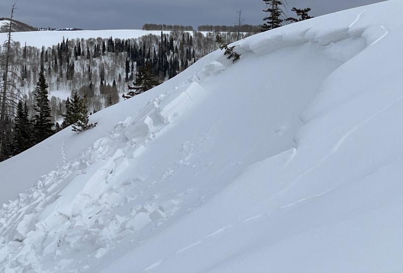
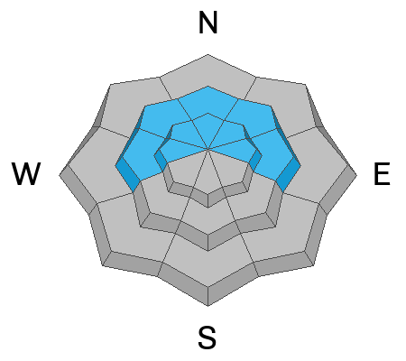
For today, the avalanche danger remains MODERATE on the Manti Skyline. Small human triggered slab avalanches are possible. The most likely place to trigger one is on steep slopes above about 8500 feet in elevation on the north half of the compass.

Low
Moderate
Considerable
High
Extreme
Learn how to read the forecast here
Avalanche Watch

What: Heavy snowfall and strong winds are expected to rapidly increase avalanche danger across northern and central Utah beginning Tuesday and continuing through the week. Forecasters at the Utah Avalanche Center expect dangerous and complex avalanche conditions to develop on many slopes, with large natural and human-triggered avalanches likely.

When: The Avalanche Watch is issued on Monday, 2/16/26 at 6:00 AM MST through 6:00 AM MST Tuesday, 2/17/26.

Where: The Avalanche Watch is for the mountains of Northern, Central, and Southwestern Utah as well as Southeastern Idaho.

Impacts:

  • Dangerous avalanche conditions are expected to develop on many slopes.
  • Avalanches can be triggered on slopes steeper than 30 degrees. The may also be triggered remotely (from a distance) or from below.

What to do:

  • Avoid traveling on or underneath steep terrain at mid and upper elevations in the backcountry.
  • Carry and know how to use avalanche rescue equipment, including a transceiver, shovel, and probe.
  • Find safer riding conditions on slopes less than 30 degrees in steepness with no overhead hazard.
Weather and Snow

General Conditions: Temperatures on Sunday made it into the low to mid 30s and cooled into the mid 20s overnight. Wind from the southwest has been generally light. The new snow from last week was welcome, there just wasn't quite enough. You'll find lots of variable crusts and unsupportable areas just under the new snow making for some funky riding conditions.

Mountain Weather: We'll have high clouds again today with temperatures into the low 30s again. Wind from the southwest will be light to start and increase to moderate speeds as the day progresses. A large low pressure trough will churn through Utah over the next four days or so. This will bring periods of snow and should stack up to a foot of snow or perhaps a bit more by the time it's all said and done.
Recent Avalanches

A small natural slab avalanche was found on Sunday in the upper Fairview Lakes zone. It looks like it released near the end of the last storm early Thursday. It broke into underlying, weak faceted snow that formed in January. This is going to be the story for some time to come.

Photo: Chris Magerl

Avalanche Problem #1
Persistent Weak Layer
Type
Location
Likelihood
Size
Description

It is very obvious how things are playing out. The weak facets that formed in January are in our face. You punch through into them while riding machines and skiing. You are "sandboxing" in them as you break through while trailbreaking on skis. The snowpack is collapsing and "whoomping" in many areas. Cracks in the snow surface are visible. We've seen a number of small natural avalanches from the last small storm that all broke into the facets. Things will only get worse with additional snow this week.

Check out these two backcountry observations that document what we're seeing:

General Announcements
This forecast is from the U.S.D.A. Forest Service, which is solely responsible for its content. This forecast describes general avalanche conditions and local variations always occur.