Forecast for the Skyline Area Mountains

Brett Kobernik
Issued by Brett Kobernik on
Sunday morning, February 15, 2026

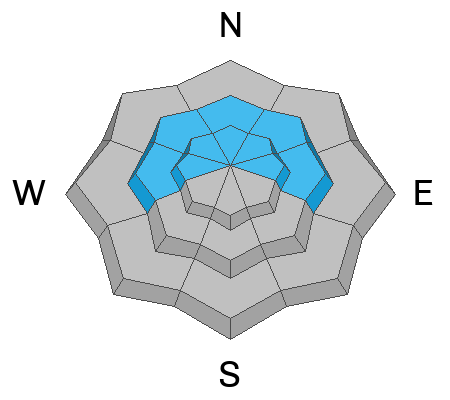
The overall avalanche danger is MODERATE today. The snowpack is fairly sensitive in many areas and human triggered avalanches are possible. The most likely places to trigger one is above about 8500' on steep slopes that are on the north half of the compass. Generally, the avalanches will be small. The danger is poised to increase during storms this coming week.

Low
Moderate
Considerable
High
Extreme
Learn how to read the forecast here
Weather and Snow

General Conditions: Temperatures reached the mid-30s in the higher terrain on Monday. Wind from the southwest has been generally light. You'll find melt-freeze crusts on sunny slopes and lower elevation terrain this morning. Upper elevation northerly facing terrain holds cold powder.

Mountain Weather: It'll be another fairly warm day with temperatures getting into the mid 30s again. Wind will probably bump up in speed a bit into the moderate range from the southwest. We're going to see high clouds. Monday looks similar with the wind increasing a bit more. Weather models continue to advertise a series of storms starting about Tuesday which could deliver a decent amount of snow through the week.
Recent Avalanches

I stumbled onto a natural avalanche that most likely released at the end of the last storm. It was shallow but propagated pretty wide. It ran about 500'. The debris fanned out and didn't appear to be very deep. This is an example of one of the larger avalanches that could be triggered today.

Avalanche Problem #1
Persistent Weak Layer
Type
Location
Likelihood
Size
Description

Here are the red flags I saw during my travel on Saturday.

  • My partner and I continued to experience collapsing of the snowpack.
  • We saw a recent natural avalanche.
  • We saw slopes with cracks across them.
  • We found very loose facets under the new layer of snow in most areas we traveled.

It's all there, folks. Regarding your terrain choice, you should be stepping back from steeper terrain to more conservative, lower-angle terrain. This will be imperative if we get more snow this coming week. Right now, the avalanches are relatively small (but still potentially dangerous). Next week, the size of the avalanches could get serious.

General Announcements
This forecast is from the U.S.D.A. Forest Service, which is solely responsible for its content. This forecast describes general avalanche conditions and local variations always occur.