Forecast for the Salt Lake Area Mountains

Bo Torrey
Issued by Bo Torrey on
Wednesday morning, April 8, 2026

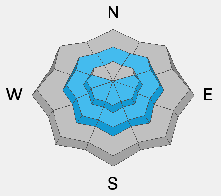
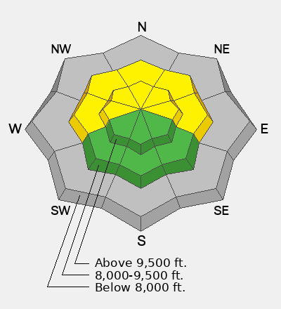
The avalanche danger will rise to MODERATE on the mid- and upper-elevation slopes facing W-N-E. As daytime temperatures warm and snow surfaces become soft, natural and human-triggered avalanches are possible. The danger is LOW on mid- and upper-elevation SW-S-SE facing slopes.

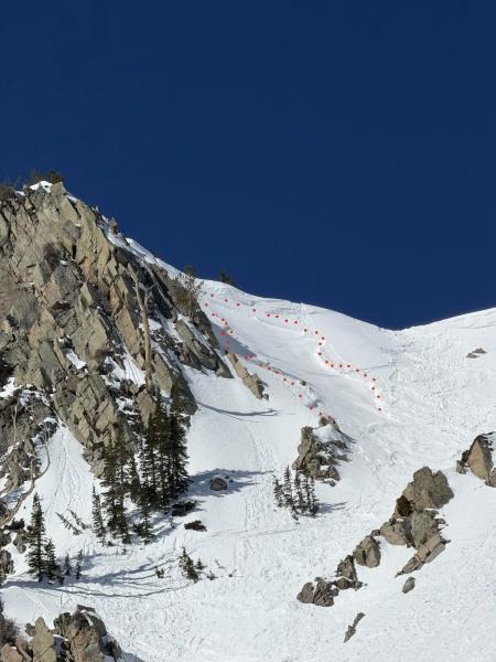
On NW-N-NE facing slopes above about 10,000 feet, it is still possible to trigger a shallow slab that fails within the recent snow.

Low
Moderate
Considerable
High
Extreme
Learn how to read the forecast here
Special Announcements

This morning's forecast was guest-written by Trevor Katz. Trevor is a Pro Observer for the UAC and spends his winters working for Park City Powder Cats as a forecaster and guide.

Human Factor Research: Researchers Ian McCammon and Sara Boilen are developing new tools for managing human factors for backcountry skiers and boarders. This survey asks about personal experiences with human factors and will take 7-8 minutes to complete. Link is HERE.

Weather and Snow

Overnight, skies were clear, and temperatures found their way into the low 30s °F. Since yesterday afternoon, winds have been blowing from the west at moderate speeds with strong gusts of around 30 mph at ridgetops. All told, a solid overnight refreeze of the snow surface can be expected.

Today, clear skies give way to scattered cloud cover this afternoon. Expect moderate winds from the west, with gusts around 30 mph along the high ridges. Temperatures will rise to the upper 50s °F.

Looking ahead, weather models show a return of colder temperatures and the potential for snow starting Saturday and lasting into early next week.

Recent Avalanches

Yesterday, a skier triggered a soft slab avalanche in Wolverine Cirque on a steep northeast-facing slope at 10,500 feet. The skier was briefly caught before skiing off the slab. On Monday, a few natural wet-loose avalanches occurred on solar aspects in upper Little Cottonwood Canyon. Recent observations can be found here.

Skier-triggered avalanche on a northeast-facing slope at 10,500 feet in the Wolverine Cirque.

Avalanche Problem #1
Wet Snow
Type
Location
Likelihood
Size
Description

With warming daytime temperatures, wet snow avalanches will become possible by later this morning. With only five days since the last storm, many snow surfaces are still unconsolidated, with wet and heavy snow present by midday, especially on W-N-E facing slopes, where there is more recent snow.

Wet loose avalanches may start small and predictable, but are capable of entraining enough snow to be destructive.

I'm trying to search for supportable snow on solar aspects this morning, but when the snow surface becomes slushy and wet, it’s time to seek lower-angle slopes.

Natural wet-loose avalanches from Monday afternoon on Sunset Peak. Photo: Torrey

Avalanche Problem #2
Wind Drifted Snow
Type
Location
Likelihood
Size
Description

Since last week’s storm, avalanches failing within the storm snow have decreased, but it remains possible to trigger a lingering pocket. The most recent examples of this problem have been on steep, upper elevation, north-facing slopes above 10,000 feet. Yesterday’s skier-triggered soft slab in Wolverine Cirque is a great reminder to keep this problem on the radar.

Soft Slab avalanche in Wolverine Cirque on a northeast-facing slope at 10,500’ Photo: D-Tron.

Additional Information

We have published February 2026: Four Avalanche Fatalities in Five Days: a community review with most of the UAC Salt Lake office. This 38-minute video is worth sitting down and digesting. A huge thanks to UAC Education Manager & Forecaster McKinley Talty for his hard work putting this together behind the scenes.

General Announcements

This information does not apply to developed ski areas or highways where avalanche control is normally done. This forecast is from the U.S.D.A. Forest Service, which is solely responsible for its content. This forecast describes general avalanche conditions and local variations always occur.