Special Avalanche Bulletin
What
The Utah Avalanche Center is issuing a Special Avalanche Advisory for all mountain regions across Utah through Sunday, March 22, as avalanche danger is expected to rise.
When
In effect from 6 AM MST Thursday to 6 AM MST Monday.
Where
The mountains of Utah and southeastern Idaho.
Impacts
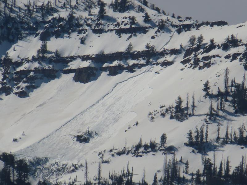
Record-breaking warm temperatures will rapidly destabilize the snowpack across the state, increasing the likelihood of widespread, spontaneous, destructive wet avalanches. Wet avalanches could occur on all aspects and at all elevations, including places that typically stay colder this time of year. Avoid travel on and below steep slopes, including avalanche runout zones and terrain traps.
After a difficult week in February that included four avalanche fatalities, UAC forecasters will host a community debrief to discuss the conditions surrounding these accidents. We will review the weather and snowpack patterns, share observations from the field, and discuss lessons learned. This event will not be live but will include time for questions and discussion, with the goal of learning together as a community. Please use the form below to submit questions for review. Submit your questions HERE.
A new version the UAC's mobile app has been released with many new features and performance improvements. Download our app today, available on iPhone and Android. Learn more HERE.
Join Caroline Miller, UAC Executive Director, in exploring a life-altering accident in the mountains. Broken Neck, Broken Systems is a deeper dive into decision-making in the mountains. Learn more HERE.
Under clear skies, mountain temperatures are about 10°F colder than they were at this time yesterday morning as a dry cold front moves through. This front dropped temperatures and increased winds overnight, which are now blowing 10–20 mph across upper-elevation terrain. Higher up, around 11,000 feet, winds are blowing 30–40 mph with gusts into the 50s. Current mountain temperatures range from 37 to 50°F.
Plenty of sunshine today, with mountain temperatures climbing into the mid to upper 50s °F. Northwest winds will remain elevated, blowing 10–20 mph with gusts into the 20s and 30s. Looking ahead, there’s a potential pattern change lining up around April 1st… hopefully it’s not an April Fool’s joke.
The snow surface should be locked up this morning and will likely hold together a bit longer than it did yesterday. Most folks found a nice window of supportable, edgeable riding before things broke down, with the snow turning wet and unsupportable by the afternoon.
UDOT Forecasters took some nice photos of recent wet slab avalanches in the Provo area. Photos below: