Forecast for the Provo Area Mountains

Drew Hardesty
Issued by Drew Hardesty on
Wednesday morning, February 25, 2026

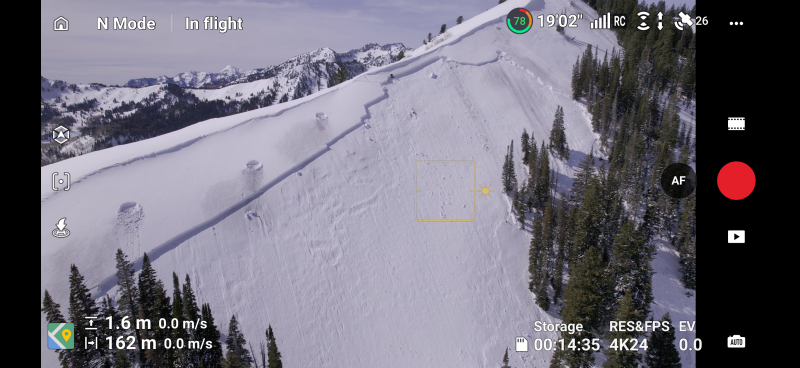
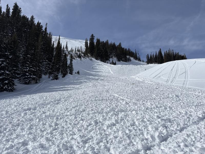
It's HIGH AVALANCHE DANGER.

Heavy rain and snow combined with moderate to strong winds has elevated the avalanche danger to HIGH on many slopes. Large and dangerous natural and human triggered avalanches are very likely. Traveling on or beneath steep (30°) terrain is not recommended. Avoid runout zones. Know that you can trigger large avalanches from below.

Low
Moderate
Considerable
High
Extreme
Learn how to read the forecast here
Avalanche Warning

What

The avalanche danger is HIGH in the backcountry today; very dangerous avalanche conditions exist, with both natural and human-triggered avalanches likely.

When

In effect from 6am MST this morning, (February 25) to 6am MST Thursday (February 26)

Where

For the mountains of Northern Utah and Southeast Idaho, including the Wasatch and Bear River mountain ranges.

Impacts

Recent heavy snow combined with wind has overloaded slopes with poor snow structure and created widespread areas of unstable snow. Both human-triggered and natural avalanches are likely. People should avoid travel in avalanche terrain and stay clear of avalanche runouts. Stay off and out from under slopes steeper than 30 degrees.

Weather and Snow

Heavy rain has engulfed the Wasatch Range with a rough rain-snow line of 8500' or higher. Temps are in the mid to upper 30s. Winds are moderate from the southwest. Precipitation totals are 1.50-2.0" in the southern Wasatch. Above the rain-snow line you will find 2-6" of very dense, very heavy snow.

For today, we'll have continued rain and snow with the rain-snow line dropping to about 8000'. We expect to see another 0.5" of H2O through the morning accompanied by moderate to strong winds from the west. Clearing later tomorrow and warming through the weekend. Another disturbance is slated for late weekend into early next week.

Recent Avalanches

Three people were killed in separate avalanche accidents in the past week, with a fourth in critical condition.

  • Wednesday 2/18 Ant Knolls, Wasatch Back Fatality — Snowmobiler. Preliminary report HERE.
  • Thursday 2/19 Rock Garden, BCC (Brighton Backcountry) Fatality — 11-year-old skier. Preliminary report HERE.
  • Saturday 2/21 Butler Basin, BCC - 1 Injured, 1 in Critical Condition — Backcountry skiers. Preliminary report HERE.
  • Sunday 2/22 Caribou Basin, Wasatch Back Fatality — Snowbiker. Preliminary report HERE.

All of these accidents involved slab avalanches 2-3' thick and up to 500' wide failing on weak faceted snow, our January Dry Layer (JDL). There's something else I want to point out - in nearly all of these and many other close calls, the individual or party triggered the avalanche from below while in gentle terrain. It's not enough to be on low angle terrain: you can collapse the slope and pull the avalanche down on top of you.

There were no reports of avalanches yesterday except for mountain roofs shedding their storm snow. Note that we have had fatalities involving roof avalanches as recently as Spring 2023 in upper Big Cottonwood (Link).

Photos from Sunday's Caribou Basin accident (Meisenheimer/Torrey) below

Avalanche Problem #1
Persistent Weak Layer
Type
Location
Likelihood
Size
Description

The persistent weak layer (PWL) has killed 3 people in the past week and accounts for roughly 70% of all avalanche fatalities in Utah.

We already have a fragile and dangerous snowpack and we're now adding significant water weight and wind loading to the equation. I anticipate long running and destructive avalanches today.

Bo Torrey rode over to the site of a very close call over the weekend near the Ant Knolls and his excellent report is HERE.

Travel Advice: Travel on or beneath avalanche terrain is not recommend.

Avalanche Problem #2
Wet Snow
Type
Location
Likelihood
Size
Description

There is a lot of uncertainty around forecasting today's wet avalanches. Many areas have seen 1.50"-2.0" of rain on a structured snowpack. My sense is that both wet loose and wet slab avalanches are likely today in some areas. Wet slabs may be more likely on west to north to east facing aspects and may run naturally in some areas.

Travel Advice: Travel on or beneath avalanche terrain is not recommend.

Avalanche Problem #3
Wind Drifted Snow
Type
Location
Likelihood
Size
Description

Above the rain-snow line, you may be able to trigger sluggish and dense fresh slabs of wind blown snow. These will be most pronounced on north to east to south facing terrain.

Additional Information

One needs to understand runout and alpha angles if traveling in the mountain environment. Chris Benson caught this footage of a very close call near Red Mountain Pass in Colorado over the weekend. These are the sort of avalanches that have left three dead and one in the hospital in Utah.

Learn more about runout and alpha angles HERE and HERE.

General Announcements

This information does not apply to developed ski areas or highways where avalanche control is normally done. This forecast is from the U.S.D.A. Forest Service, which is solely responsible for its content. This forecast describes general avalanche conditions and local variations always occur.