Forecast for the Ogden Area Mountains

Greg Gagne
Issued by Greg Gagne on
Monday morning, March 16, 2026

The avalanche danger is LOW and the snowpack is generally stable. Mountain travel has inherent risks, and Normal Caution is advised.

There is the potential for small avalanches involving wet-loose snow on sunny, wind-sheltered slopes.

Expect a rising avalanche danger by mid-week with a significant warm-up.

(Gray on the danger rose indicates little to no snow.)
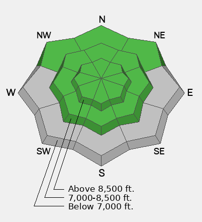
Low
Moderate
Considerable
High
Extreme
Learn how to read the forecast here
Special Announcements

Spring Campaign and Spring Auction - Each spring, we ask for your continued financial support to fund our forecasting and education programs. We hope you will consider supporting our mission by checking out our campaign and auction, live and available HERE.

Weather and Snow

This morning: Skies are partly cloudy and temperatures range through the 20's °F. Winds are from the west/northwest and strong, with overnight gusts near 40 mph along exposed mid and upper-elevation ridges and peaks.

Today: Skies will be partly cloudy with temperatures rising into the upper 30's and low 40's °F. Winds will diminish slightly throughout the day, but remain moderate to strong, gusting into the 20's and 30's mph, with stronger gusts at the upper-most elevations.

This week: Enjoy today's cool temperatures as we enter a significant period of warming by mid-week, with mountain temperatures soaring into the 50's and 60's °F.

Recent Avalanches

We received no reports of avalanches over the weekend.

You can find more observations from the Ogden mountains HERE.

Avalanche Problem #1
Normal Caution
Type
Location
Likelihood
Size
Description

We use Normal Caution when the avalanche danger is Low and there is no specific avalanche problem. Risks are inherent in mountain travel, and there is always the potential for avalanches, including:

Wet Snow: Today's cool temperatures, winds, and cloud cover should keep the snow surface frozen, but wet-loose avalanches are possible in sunny, wind-sheltered terrain.

Wind Drifted Snow: You may find small pockets of wind-drifted snow in exposed terrain at the mid and upper elevations.

Persistent weak layer (PWL) was dropped as an avalanche problem this weekend, but the potential exists for an avalanche to fail on the PWL on steep, north-facing, upper-elevation slopes where the snowpack is unsupported (such as around rocks).

Glide avalanches have been releasing naturally in the past week in the Salt Lake mountains and we have some similar terrain in the Ogden mountains. These full-depth and destructive slides are difficult to forecast and it's worth avoiding known habitat (on steep and smooth rock slabs) and their runouts zones, such as the Chilly Peak Slabs.

Additional Information

What does it mean to drop the PWL?


Graphic courtesy of Joe Stock's 2024 piece in The Avalanche Review.

You'll notice that we dropped the persistent weak layer (PWL)—that's responsible for 4 deaths since mid-February—as a problem yesterday. What we want you to know is that there is a fair bit of uncertainty around dropping a PWL from the forecast. We don't drop a PWL because it's impossible to trigger. In fact, it is literally impossible to be 100% certain that there is not a single lingering weakness. As seen in the graphic, a PWL comes with an inherently higher amount of uncertainty, as do glide avalanches—like the one that ran in Broads yesterday. Know as you travel today that uncertainty lingers in the mountains—and we deal with uncertainty by adding margins. Visiting avalanche pro Lisa Van Sciver put it well in her ob when she wrote, "While the snowpack in this is area is generally stable, in extreme terrain especially unsupportable slopes this structure should be considered..."

Uncertainty is a tough thing to communicate in avalanche forecasting; that's why multiple PhDs are studying it. An important finding so far is that explicitly stating our uncertainty in our forecasts increases trust in the avalanche center. So know: we have some surrounding the PWL. As temps skyrocket next week, know you may find it coming back into the forecast.

General Announcements

This information does not apply to developed ski areas or highways where avalanche control is normally done. This forecast is from the U.S.D.A. Forest Service, which is solely responsible for its content. This forecast describes general avalanche conditions and local variations always occur.