Forecast for the Ogden Area Mountains

Nikki Champion
Issued by Nikki Champion on
Tuesday morning, January 6, 2026

The avalanche danger is CONSIDERABLE at upper elevation aspects facing W‑N‑E, where human-triggered avalanches are likely and natural avalanches are possible. Avalanches may fail one to two feet deep in new or wind-drifted snow, but can also step down to weak layers buried up to three feet deep on northerly slopes.

Clear skies and soft snow may tempt riders, but the snowpack remains dangerous. Most accidents and fatalities occur after peak instability—today has accident written all over it. Avalanche terrain can be avoided, and excellent riding exists on lower-angle slopes (under 30°).

People stepping out of bounds at ski areas face the same dangerous conditions.

Low
Moderate
Considerable
High
Extreme
Learn how to read the forecast here
Special Avalanche Bulletin

What

The Utah Avalanche Center is warning of dangerous avalanche conditions throughout the mountains of northern Utah this week, where heavy snowfall and strong winds have created a CONSIDERABLE avalanche danger. Large and unsurvivable tree snapping avalanches 4-6 feet deep have already occurred, multiple riders have been critically buried in an avalanche in the Brighton backcountry since Friday, and more human-triggered avalanches are expected, with natural avalanches possible.

When

In effect from 6AM MST today to 6AM MST Wednesday

Where

For the mountains of Northern Utah, including the Wasatch Range...Uinta Mountains.

Impacts

Dangerous avalanche conditions exist on many slopes. Avalanches are likely to be triggered by anyone traveling on or below slopes steeper than 30 degrees and may be triggered remotely (from a distance) or from below. People stepping out of bounds at a ski area are stepping into the same dangerous avalanche conditions.

Special Announcements

Be mindful of avalanche workers - IF YOU TRIGGER an avalanche near a ski area, please report it to the ski patrol dispatch or Alta Central (801-742-2033). Rescue personnel don’t want to be subjected to dangerous conditions if the scene is clear. More on this in Backcountry Emergency Protocols

Weather and Snow

This morning, skies are clear, and the storm appears to have exited the region. Winds are out of the west southwest and sustained, averaging in the teens mph, with gusts in the upper 20s and 30s mph along exposed mid and upper elevation ridgelines (prime speeds for building fresh wind drifts).

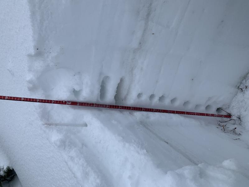
As of 5 AM, final storm snow water equivalent totals (in inches) include:

→ 13-19" snow (up to 3.1" water)

Today will shape up to be a beautiful day in the mountains, with sunny skies and occasional high clouds. Temperatures will climb into the low 30s °F. Winds will continue to blow from the west southwest, averaging 10–15 mph along exposed mid and upper elevation ridgelines, with gusts up to 35 mph.

After a brief lull, another storm is expected later Wednesday. This looks to be a more traditional system, bringing colder temperatures and lower density snowfall. Confidence is high for snow along and just behind the cold front, though remaining uncertainties in storm timing and density will ultimately shape final snowfall and SWE totals.

Recent Avalanches

No new avalanches reported from the Ogden area backcountry. Ski resorts reported that the avalanches were mostly confined to recent snow, with dry loose and soft slabs on mid and upper N‑E aspects. Explosives and natural slides affected storm and wind slabs, but nothing stepped down into older layers.

Read all backcountry observations here.

Avalanche Problem #1
Wind Drifted Snow
Type
Location
Likelihood
Size
Description

Moderate to strong W‑SW winds will continue drifting snow onto leeward N and E aspects, with cross-loading possible onto S and W slopes. Cracking indicates sensitive wind slabs.

Outside the wind zone: new storm snow is less sensitive, though lingering reactive pockets remain. Dense storm slabs may let you travel farther onto a slope before triggering.

Avalanches involving new or wind-drifted snow can step down 1–2' to the Christmas or New Year’s rain crust, or deeper to faceted snow near the ground, with slides over four feet deep possible.

Avalanche Problem #2
Persistent Weak Layer
Type
Location
Likelihood
Size
Description

Although these avalanches below occurred in the Salt Lake mountains, a similar snowpack exists in the upper elevations of the Ogden mountains. There have been no recent backcountry, or ski patrol reported avalanches stepping down into the old snow, but the structure still exists.

Sunday's avalanche in Two Dogs, along with now four avalanches in Hidden Canyon this past week, all failed in weak snow near the ground. The Two Dogs slide may be a warning that on many slopes where the persistent weak layer (PWL) exists, the weight of new and wind-driven snow is finally enough to trigger large, destructive avalanches.

What to do today: Avoid traveling on, underneath, or adjacent to any slope approaching 30° or steeper on upper elevation aspects facing west, north, or east.

Pit hand hardness from Cutler Ridge Sunday - Find the full observation HERE.

General Announcements

This information does not apply to developed ski areas or highways where avalanche control is normally done. This forecast is from the U.S.D.A. Forest Service, which is solely responsible for its content. This forecast describes general avalanche conditions and local variations always occur.