Forecast for the Moab Area Mountains

Eric Trenbeath
Issued by Eric Trenbeath on
Sunday morning, March 8, 2026

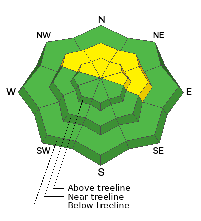
The avalanche danger is MODERATE on steep slopes near and above treeline that face NW–N–NE–E. In these areas, hard slab, human-triggered avalanches 2–4 feet deep failing on a buried persistent weak layer remain POSSIBLE. If released, they could step down and involve the entire season’s snowpack.

Although the odds of triggering an avalanche have decreased, the consequences remain the same. Personally, I'll be continuing to avoid steep, northerly aspects near and above treeline.

Low
Moderate
Considerable
High
Extreme
Learn how to read the forecast here
Special Announcements

Geyser Pass Road Conditions: The road was not plowed after the last storm. Expect a little snow and ice up high, and muddy conditions as the day heats up.

Grooming: No grooming is scheduled. Expect a few inches of fresh snow on trails.

Mountain Film on Tour returns to Star Hall in Moab on Saturday, March 14. Tickets are available online and all proceeds benefit UAC Moab. Look forward to seeing you all there!

All accident reports are completed from the deadly week in northern Utah. Our sincerest condolences to all of those affected.

Weather and Snow

24 Hour Snow: 0" 72 Hour Snow: 4" Season Total Snow: 75" Depth at Gold Basin: 35"

Winds on Pre-Laurel Peak: N 5-10 Temp: 18°F

Weather

Under clear skies, northerly winds are light and mountain temps are in the upper teens to lower 20's. Look for sunny skies today with high temps rising into the upper 30's at 10,000 feet. Warm and dry conditions are ahead with more potentially record breaking temperatures for the upcoming week.

General Conditions

Friday's storm saw winter's last gasp with 4-5 inches of new snow. Travis and Dave made the most of it yesterday, and they reported decent turning in the fresh snow over a firm and supportable base. They also reported some mild wind affect up high, and said that the new snow definitely took on some heat during the day so expect sun exposed slopes to be lightly crusted over this morning.

Maggie Nielsen sent in this observation with an excellent pit profile that clearly details our persistent weak layer problem. The greatest threat from avalanches continues to be on northerly aspects near and above treeline, where hard slabs exist over layers of weak, dry, faceted snow. This is a notoriously unpredictable setup that offers little to no warning before failing. It’s a familiar pattern for seasoned La Sal skiers and riders, and the safest approach remains the same: avoid steep terrain on the north half of the compass.

Travis Nauman making the most of winter's last gasp high in Gold Basin.

See all Moab observations here.

Snowpack and Weather Data

Wind Station on Pre-Laurel Peak (11,400')
NWS forecast for the La Sal Mountains.
Recent Avalanches
No recent avalanches have been observed. The avalanche database has been updated to include all observed avalanches from the last cycle. These are all great examples of the type of avalanche that are possible to trigger.
Avalanche Problem #1
Persistent Weak Layer
Type
Location
Likelihood
Size
Description

It’s been two weeks since the last storm and avalanche cycle. Buried persistent weak layers are slowly adjusting to the load and are becoming more stubborn to trigger. Obvious red flags like collapsing and cracking have faded, but the underlying snowpack structure remains poor. The danger has dropped to moderate, but the consequences of triggering an avalanche remain severe.

On northerly aspects near and above treeline, thick hard slabs—2 to 4 feet deep—rest on top of these persistent weak layers. This is a highly unpredictable setup, and committing to steep slopes with this structure is a gamble. If triggered, avalanches could step down and take out the entire season’s snowpack.

Thin, rocky areas, steep convex rollovers, and slab margins remain likely trigger points. When the payoff for riding steep terrain is minimal, it’s hard to justify the risk. Our approach continues to be simple: avoid steep slopes in this terrain altogether.

I shot this video last Sunday while we were still at considerable danger. We have since moved into moderate but there are some salient points to take home.

Additional Information
General Announcements
This forecast is from the U.S.D.A. Forest Service, which is solely responsible for its content. This forecast describes general avalanche conditions and local variations always occur.