Forecast for the Moab Area Mountains

Eric Trenbeath
Issued by Eric Trenbeath on
Saturday morning, March 21, 2026

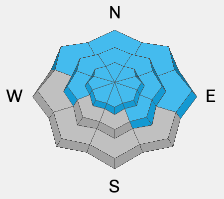
The danger will quickly rise to CONSIDERABLE on all steep slopes that hold snow. Human triggered, wet-loose and wet-slab avalanches are likely, and natural avalanches are possible. Punchy, unsupportable conditions are signs that the snowpack is on the edge and it will quickly become wet, sloppy, and unstable as the day heats up. Travel in avalanche terrain is not recommended.

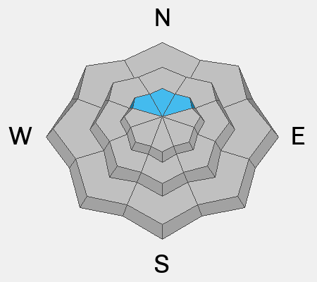
Gray on the rose indicates areas that are mostly clear of snow. Some variations occur.

Low
Moderate
Considerable
High
Extreme
Learn how to read the forecast here
Special Avalanche Bulletin
What

The Utah Avalanche Center is issuing a Special Avalanche Advisory for all mountain regions across Utah beginning Thursday, March 19, through Sunday, March 22, as avalanche danger is expected to rise in the coming days.

When

In effect from 6 AM MST Thursday to 6 AM MST Monday.

Where

The mountains of Utah and southeastern Idaho.

Impacts

Record-breaking warm temperatures will rapidly destabilize the snowpack across the state, increasing the likelihood of widespread, spontaneous, destructive wet avalanches. Wet avalanches could occur on all aspects and at all elevations, including places that typically stay colder this time of year. Avoid travel on and below steep slopes, including avalanche runout zones and terrain traps.

Warning Times

Thursday, March 19, 2026 - 6:00 am to Monday, March 23, 2026 - 6:00 am

Special Announcements

Geyser Pass Road Conditions: The road is melted down to dirt.

Grooming: Grooming is done for the season.

Spring Fundraiser: Each spring, we ask for your continued financial support to fund our forecasting and education programs. Our Spring Campaign and Spring Auction are now live and we hope you will consider supporting our mission.

A new version the UAC's mobile app has been released with many new features and performance improvements. Download our app today, available on iPhone and Android.

After a difficult week in February that included four avalanche fatalities, UAC forecasters will host a community debrief to discuss the conditions surrounding these accidents. We will review the weather and snowpack patterns, share observations from the field, and discuss lessons learned. This event will not be live but include time for questions and discussion, with the goal of learning together as a community. Please use this form to submit questions for review.

Weather and Snow

24 Hour Snow: 0" 72 Hour Snow: 0" Season Total Snow: 75" Depth at Gold Basin: 28"

Winds on Pre-Laurel Peak: S 10-15 Temp: 42°F

Weather

It's a scorching 41°F in Gold Basin this morning and 44°F on top of Pre Laurel Peak at 11,700 feet. Temperatures will again soar today reaching the low 60's at 10,000 feet. Adding insult to injury, SW winds will be on the increase blowing in the 20- 30 MPH range along ridge tops with gusts as high as 40 MPH. We'll see a little relief tomorrow from a passing "cold" front with highs in the 50's. 60 degree temperatures return again early next week with no overnight freezes in sight.

General Conditions

We've now had three nights without a re-freeze and temperatures soared to 60°F yesterday at 10,000 feet. The snowpack will be largely unsupportable from the get go this morning and as the day heats up the likelihood for human triggered wet-loose and wet slab avalanches will quickly rise. In my travels yesterday, I did find areas with supportable travel in the morning but by afternoon, punching through into a sloppy wet mess was becoming more widespread. Gaining elevation helps but it's not trustworthy, and the terrain you have to move through to get there and back just doesn't make it safely feasible. The snow is going quickly with patches of dirt coming out on the Geyser Pass Road above the trailhead, and on the trail into Gold Basin. Most south facing terrain is bare and I'm afraid we're looking at the end here. For more on overall conditions, including a large, wet slab avalanche, see the video below.

See all Moab observations here.

Snowpack and Weather Data

Wind Station on Pre-Laurel Peak (11,400')
NWS forecast for the La Sal Mountains.
Recent Avalanches
In my travels yesterday, I ran across this large, natural wet slab avalanche in Talking Mountain Cirque. A likely suspect and frequent runner during March and April heatwaves, this nevertheless, illustrates the type of problem we are dealing with.
See the full avalanche database.
Avalanche Problem #1
Wet Snow
Type
Location
Likelihood
Size
Description

Human triggered wet-loose and wet-slab avalanches are likely on all aspects that have snow, and natural avalanches are possible. The primary concern is wet-slab avalanches which are more destructive and far less predictable than wet-loose slides. While wet slabs can be difficult to anticipate, the red flags are painfully obvious today - soaring heat, saturated surface snow, unsupportable conditions, not to mention a recent, large, wet slab avalanche. The danger for this problem decreases slightly on upper elevation, northerly aspects but nowhere is safe. Avoiding avalanche terrain is recommended today.

Avalanche Problem #2
Persistent Weak Layer
Type
Location
Likelihood
Size
Description

On upper elevation, northerly aspects, persistent weak layers of loose, dry, faceted snow still exist, and warm temperatures have increased the likelihood for reactivating these weak layers. As the heatwave continues, meltwater will saturate the snowpack, even up high, and this problem will soon be absorbed into a wet slab problem. Either way, the same rules apply, and avalanche terrain should be avoided.

Additional Information
General Announcements
This forecast is from the U.S.D.A. Forest Service, which is solely responsible for its content. This forecast describes general avalanche conditions and local variations always occur.