Forecast for the Moab Area Mountains

Dave Garcia
Issued by Dave Garcia on
Thursday morning, March 19, 2026

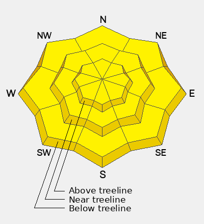
Rising mountain temperatures will increase the avalanche danger to MODERATE on all steep slopes. As the day warms, wet-loose and wet-slab avalanches will become possible. Monitor the snow surface closely—rollerballs, saturated snow, and unsupportable conditions are clear signs it’s time to head home.

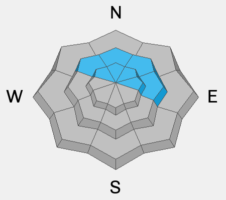
Extreme heat is the primary concern, but lingering persistent weak layers on shaded slopes near and above treeline still deserve attention. This week’s unusually warm temperatures may reactivate these buried weaknesses, making slab avalanches failing on faceted snow possible in this terrain.

In the alpine, hard slabs 2 to 4 feet thick remain perched over weak, faceted layers. While triggering these avalanches is becoming less likely, the consequences remain severe.

Low
Moderate
Considerable
High
Extreme
Learn how to read the forecast here
Special Avalanche Bulletin
What

The Utah Avalanche Center is issuing a Special Avalanche Advisory for all mountain regions across Utah beginning Thursday, March 19, through Sunday, March 22, as avalanche danger is expected to rise in the coming days.

When

In effect from 6 AM MST Thursday to 6 AM MST Monday.

Where

The mountains of Utah and southeastern Idaho.

Impacts

Record-breaking warm temperatures will rapidly destabilize the snowpack across the state, increasing the likelihood of widespread, spontaneous, destructive wet avalanches. Wet avalanches could occur on all aspects and at all elevations, including places that typically stay colder this time of year. Avoid travel on and below steep slopes, including avalanche runout zones and terrain traps.

Warning Times

Thursday, March 19, 2026 - 6:00 am to Monday, March 23, 2026 - 6:00 am

Special Announcements

Geyser Pass Road Conditions: The road is melted down to dirt, expect wet and muddy conditions as the day heats up.

Grooming: Grooming is done for the season.

Spring Fundraiser: Each spring, we ask for your continued financial support to fund our forecasting and education programs. Our Spring Campaign and Spring Auction are now live and we hope you will consider supporting our mission.

A new version the UAC's mobile app has been released with many new features and performance improvements. Download our app today, available on iPhone and Android.

After a difficult week in February that included four avalanche fatalities, UAC forecasters will host a community debrief to discuss the conditions surrounding these accidents. We will review the weather and snowpack patterns, share observations from the field, and discuss lessons learned. This event will not be live but include time for questions and discussion, with the goal of learning together as a community. Please use this form to submit questions for review.

Weather and Snow

24 Hour Snow: 0" 72 Hour Snow: 0" Season Total Snow: 75" Depth at Gold Basin: 28"

Winds on Pre-Laurel Peak: NW 20 Temp: 36°F

Weather

Under clear skies, it is 36°F in Gold Basin this morning. For today, skies will be sunny, and temperatures will soar to 60°F at 10,000 feet. Winds from the west will blow 5 to 15 MPH with gusts up to 25 MPH. Abnormally warm temperatures and dry conditions are still the focus, with daytime highs 15 to 25 degrees above normal. Record highs continue into next week.

General Conditions

Overnight temperatures were in the mid-30s°F, and the mountains did not get a refreeze. The snow surface may have a superficial refreeze, but any window for corn skiing will be very short this morning. Ryan Huels was in the mountains yesterday and observed some small wet-loose activity. The possibility of wet-loose avalanches increases today with even warmer temperatures. And with no overnight refreeze, wet-slab avalanches are also possible today. Wet-slab avalanches are notoriously unpredictable, but they can be large and destructive. Pay close attention to the snow surface. When the surface becomes saturated and punchy, it's time to head home.

In the video below, I discuss the incoming heat wave and what it means for our snowpack.

In case you are wondering, this is officially the worst snowpack ever at 36% of normal. The black line is this season and just dropped below the historical minimum. We generally reach peak snowpack in mid April, this year it was late February. Uggh.

See all Moab observations here.

Snowpack and Weather Data

Wind Station on Pre-Laurel Peak (11,400')
NWS forecast for the La Sal Mountains.
Recent Avalanches
No recent avalanches have been observed. The avalanche database has been updated to include all observed avalanches from the last cycle. These are all great examples of the type of avalanche that are possible to trigger.
Avalanche Problem #1
Wet Snow
Type
Location
Likelihood
Size
Description

Both wet-loose and wet-slab avalanches are possible today. Expect the typical springtime cycle of wet-loose activity on any sun-exposed slopes with snow. Plan for a “get in, get out” approach, as the hazard will rise quickly with daytime warming.

The primary concern is wet-slab avalanches, which are more destructive and far less predictable than wet-loose slides. The potential for wet slabs exists on most aspects today, with the exception of the highest elevation northerly terrain. While wet slabs can be difficult to anticipate, the same red flags apply: rollerballs, saturated surface snow, and unsupportable conditions are clear signs it’s time to head out.

Trend: Increasing Danger. Avalanche danger involving wet snow will rise each day through the weekend. A historically shallow snowpack with poor structure adds to the concern. Wet-slab avalanches are possible today and could become likely as early as tomorrow. By late week and into the weekend, mountain travel will become increasingly hazardous, and desert recreation will be a safer choice.

Avalanche Problem #2
Persistent Weak Layer
Type
Location
Likelihood
Size
Description

Buried layers of weak, faceted snow continue to plague our snowpack near and above treeline on northerly facing slopes. Above treeline, thick, hard slabs 2-4 feet thick sit on top of these persistent weak layers. Although the likelihood for triggering a deep and dangerous avalanche has significantly decreased, all it takes is finding the right trigger point such as a shallow, rocky area or thin spot over a convexity.

The upcoming heatwave will likely increase the sensitivity of these weak layers. Cold, dry facets can often come back to life during periods of extreme heat. Right now, the risks of entering steep northerly terrain outweigh the potential rewards.

Additional Information
General Announcements
This forecast is from the U.S.D.A. Forest Service, which is solely responsible for its content. This forecast describes general avalanche conditions and local variations always occur.