Forecast for the Moab Area Mountains

Eric Trenbeath
Issued by Eric Trenbeath on
Friday morning, January 30, 2026

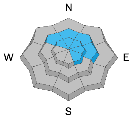
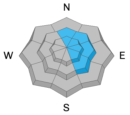
There is a MODERATE avalanche danger today on all steep slopes near and above treeline that face northwest through southeast. The avalanche problem is two-fold. It remains possible for skiers and riders to trigger slab avalanches on deeply buried persistent weak layers. These avalanches may initially break up to two feet deep, but could step down into deeper weak layers and take out the entire season’s snowpack. These avalanches would be large and dangerous. The most effective way to avoid this problem is to stay off slopes steeper than 30 degrees.

Recent strong winds and heavy drifting have elevated the chance of triggering a wind-drifted snow avalanche. This problem exists near treeline and above on slopes that face north through southeast. These are the very same slopes that harbor the persistent weak layer problem. Avoid steep, wind drifted slopes in these areas.

Low
Moderate
Considerable
High
Extreme
Learn how to read the forecast here
Special Announcements

Geyser Pass Road Conditions: The road is plowed but it remains slick and snowpacked, 4x4 and good tires are recommended.

Grooming: Trails have seen a lot of traffic and are not freshly groomed.

We are looking to reschedule our Moab Backcountry 101 Class to February 20, 21 in the hopes that we will have more snow. Click here for information and registration. Moab and Monticello locals can use the discount code MOAB-LOCAL for a 10% discount.

Weather and Snow

24 Hour Snow: 0" 72 Hour Snow: 0" Season Total Snow: 44" Depth at Gold Basin: 28"

Winds on Pre-Laurel Peak: NNW Light Temp: 12°F

Weather

Southeastern Utah will remain embedded in a dry northwest flow with a ridge to the west and a trough to the east. As such, we'll see mostly clear skies, light winds blowing from the northwest, and gradually warming temperatures through the weekend. Today will be the coolest day with highs reaching the low to mid 20's at 10,000 feet. The news gets even worse next week as models indicate a Rex Block setting up over the West Coast, with a low over Baja California, and a high centered over Nevada. This would keep us sunny and dry, deflecting any potential systems to our north and east.

General Conditions

It's now been just about a week since our last snow storm. Strong winds from the west ramped up once again on Wednesday and Dave observed heavy snow transport during his tour along the Mann's - Tomasaki ridgeline. Windward slopes took on even more scouring, while another round of wind-drifted snow was deposited on the leeward slopes. Recently forme drifts may still be reactive to the weight of skiers and riders today. The very same slopes that were recently loaded also harbor buried persistent weak layers. Human-triggered avalanches failing on multiple deeply buried weak layers remain possible. With the combination of recent loading and buried weak layers of concern, the simple strategy is to avoid steep slopes near and above treeline with a northerly component to their aspect. Soft snow can still be found on sheltered, shady aspects below treeline.

See more recent observations here.

Snowpack and Weather Data

Gold Basin SNOTEL site (10,000')
SNOTEL site near Geyser Pass Winter Trailhead (9600')
Wind Station on Pre-Laurel Peak (11,400')
NWS forecast for the La Sal Mountains.
Recent Avalanches
The weekend storm produced a decent round of natural activity including dry loose, soft slab, and hard slab avalanches. We have been getting around the past few days and viewing the recent activity. The avalanche database has been updated with the latest information and can be viewed here.
Avalanche Problem #1
Persistent Weak Layer
Type
Location
Likelihood
Size
Description

Several layers of faceted snow exist within the snowpack. Blowing and drifting snow over the past 24 hours will put even more stress on these layers. A layer of near-surface facets was buried under the most recent storm snow. This layer is likely sensitive to a person's weight and may be the first place an avalanche fails. Avalanches that start here can step down into deeper, more problematic persistent weak layers both above and below the Christmas rain crust. Avalanches can also initiate on these more deeply buried layers.

Any avalanche that fails below the crust would be large and dangerous, potentially breaking to the ground and taking out the entire season’s snowpack. In many areas near treeline and below, the snowpack remains faceted top to bottom and lacks a cohesive slab. Where a slab does exist, the snowpack structure is poor.

The key is to look for signs of strong snow over weak snow—hard snow over soft snow. If you find a slab, carefully evaluate that slope or avoid it altogether. This problem is most pronounced on north and east-facing slopes, but it also exists on northwest and southeast-facing aspects.

Avalanche Problem #2
Wind Drifted Snow
Type
Location
Likelihood
Size
Description

Strong winds blowing from the west on Wednesday formed slabs of wind drifted snow on slopes near treeline and above that face north through southeast. Although these slabs have likely gained some strength, these are the very same slopes that harbor buried persistent weak layers. The additional wind loading will increase the likelihood of human triggered avalanches failing on these weak layers, so I'm going to avoid steep, wind loaded slopes that face N-NE-E-SE.

Strong winds and heavy drifting will have penetrated the near treeline zone as well. Be on the lookout for sensitive drifts further downslope than we might typically expect. Be suspicious of mid-slope terrain features like steep convexities and gully walls.

Heavy snow transport on Wednesday on the north face of Mellenthin.

Additional Information
General Announcements
This forecast is from the U.S.D.A. Forest Service, which is solely responsible for its content. This forecast describes general avalanche conditions and local variations always occur.