Forecast for the Moab Area Mountains

Eric Trenbeath
Issued by Eric Trenbeath on
Sunday morning, January 18, 2026

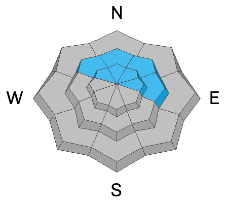
Although the odds are decreasing, a MODERATE danger still exists for human triggered, hard slab avalanches failing on a deeply buried persistent weak layer. This problem exists on all steep slopes near tree line and above that face NW-N-NE- E. The danger is most prominent on above tree line slopes that face north to east. Avalanches failing on this layer would be between 2 and 5 feet deep, and may propagate widely. You can avoid this problem by sticking to slopes less steep than 30 degrees.

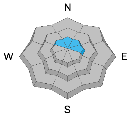
While also becoming less likely, it is still POSSIBLE to trigger a slab of wind-drifted snow above tree line on slopes with a northerly component to their aspect.

Low
Moderate
Considerable
High
Extreme
Learn how to read the forecast here
Special Announcements

Geyser Pass Road Conditions: The road is mostly dry dirt with patches of ice and packed snow up high.

Grooming: Geyser Pass was groomed on Saturday.

We are looking to reschedule our Moab Backcountry 101 Class to February 20, 21 in the hopes that we will have more snow. Click here for information and registration. Moab and Monticello locals can use the discount code MOAB-LOCAL for a 10% discount.

Weather and Snow

24 Hour Snow: 0" 72 Hour Snow: 0" Season Total Snow: 36" Depth at Gold Basin: 22"

Winds on Pre-Laurel Peak: NW 10-15 G 45 Temp: 21° F

Weather

The good news is that the north to south jet tilt responsible for recent strong northerly winds has finally moved on to the east. The bad news is that high pressure remains entrenched over the region. A potential pattern shift is afoot later in the week but I don't see any significant storms for our area through the end of the month.

General Conditions

In my travels yesterday I found just about every kind of snow surface imaginable but on the bright side, there is enough snow cover to get around on, and the Christmas rain crust is still keeping us above the basal facets. Some slopes have been smoothed over and the rocks are mostly covered. Other slopes, especially wind scoured ones above tree line, not so much. I was pleased to see southwest aspects are still holding snow but slopes facing due south are getting quite thin. Poor snowpack structure remains with weak, faceted snow beneath the Christmas rain crust. The surface snow is also starting to weaken and in sheltered areas, it won't be long before the whole snowpack is faceted through.

Snowpack and Weather Data

Gold Basin SNOTEL site (10,000')
SNOTEL site near Geyser Pass Winter Trailhead (9600')
Wind Station on Pre-Laurel Peak (11,400')
NWS forecast for the La Sal Mountains.
Decent snow cover in Talking Mountain Cirque, all things considered.
Recent Avalanches
It's been more than a week since a large snowmobile-triggered avalanche occurred on the East Face of Laurel Peak in Dark Canyon. Although the odds are decreasing, this type of avalanche remains possible. See the report here.
Click here for the complete avalanche database.
Avalanche Problem #1
Persistent Weak Layer
Type
Location
Likelihood
Size
Description

Poor snowpack structure remains, and it has proven capable of producing large, destructive human-triggered avalanches. The likelihood of triggering one of these avalanches is decreasing, but the consequences remain severe. Any avalanche failing on the PWL will take out the entire season’s snowpack and will instantly be a season-ender, or worse. The weak layer of concern is right below the Christmas rain crust. In some locations, this crust may temporarily support the weight of a skier or rider, but its ability to bridge underlying weaknesses is highly variable and unreliable. The most dangerous slopes are above tree line and face north and east, especially those that harbor a more robust slab from previous wind loading.

If you are considering venturing into avalanche terrain start off with small pieces. Avoid slopes with steep convexities and terrain traps, as well as thin rocky areas and slab margins. This problem can be avoided altogether by sticking to slopes less steep than 30 degrees.

This extended column test, performed on a north aspect near tree line at 10,800 feet, scored ECTP30. Failure was on facets beneath the clearly visible, Christmas rain crust. For more details and a full profile, see my observation.

Avalanche Problem #2
Wind Drifted Snow
Type
Location
Likelihood
Size
Description
While becoming less likely, it is still possible to trigger a stiff slab of wind-drifted snow above treeline, especially on slopes with a northerly component to their aspect. Old, hardened drifts are less sensitive to the weight of a rider and may allow you to get further out onto the slab before they break. These slabs will sound hollow and drum-like when you step on them. Any triggered wind drift has the potential to step down to more deeply buried persistent weak layers.
Additional Information
General Announcements
This forecast is from the U.S.D.A. Forest Service, which is solely responsible for its content. This forecast describes general avalanche conditions and local variations always occur.