Forecast for the Moab Area Mountains

Eric Trenbeath
Issued by Eric Trenbeath on
Saturday morning, January 17, 2026

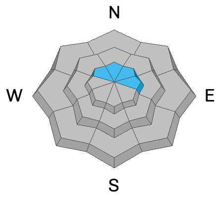
There is a MODERATE danger for hard slab avalanches failing on deeply buried persistent weak layers. It is POSSIBLE to trigger avalanches three to five feet deep that will propagate widely. This problem exists on all steep slopes near treeline and above that face NW, N, NE, and E. The danger is most prominent on above treeline slopes that face north to east. You can avoid this problem by sticking to slopes less steep than 30 degrees.

While becoming less likely, it is still POSSIBLE to trigger an old wind-drift above treeline on slopes with a northerly component to their aspect.

Low
Moderate
Considerable
High
Extreme
Learn how to read the forecast here
Special Announcements

Geyser Pass Road Conditions: The road is plowed with areas of dry ground down low, icy and snow packed up high.

Grooming: LUNA groomed all trails on Wednesday.

We are looking to reschedule our Moab Backcountry 101 Class to February 20, 21 in the hopes that we will have more snow. Click here for information and registration. Moab and Monticello locals can use the discount code MOAB-LOCAL for a 10% discount.

Weather and Snow

24 Hour Snow: 0" 72 Hour Snow: 0" Season Total Snow: 36" Depth at Gold Basin: 22"

Winds on Pre-Laurel Peak: NNW 30-35 G 45 Temp: 20° F

Weather

Winds blowing from the northwest continue their rein of terror averaging 30-35 mph along ridge tops. Temperatures will be a few degrees cooler today reaching around 28°F at 10,000 feet. High pressure continues into mid next week.

General Conditions

The snowpack is thin and the surface is variable. Above tree line, exposed northerly aspects are heavily wind-damaged. You can still trigger a lingering wind slab on above tree line slopes that have seen more recent drifting. Slab avalanches failing on weak faceted snow near the ground remain our primary concern.

Snowpack and Weather Data

Gold Basin SNOTEL site (10,000')
SNOTEL site near Geyser Pass Winter Trailhead (9600')
Wind Station on Pre-Laurel Peak (11,400')
NWS forecast for the La Sal Mountains.
Recent Avalanches
On Wednesday, Dave spotted a couple of natural wind slab avalanches in Miner's Basin that most likely occurred from strong winds earlier in the week. With continued windy conditions, you'll need to remain alert to this potential scenario.
This is a northeast aspect and the crown is at 10,800 feet. The crown looks to be about a foot deep.
This is a northeast aspect at 11,000 feet. The crown is about 6 inches deep.
On Friday, January 9, a large snowmobile-triggered avalanche occurred on the East Face of Laurel Peak. A full accident report has been published here.
Click here for the complete avalanche database.
Avalanche Problem #1
Persistent Weak Layer
Type
Location
Likelihood
Size
Description

Poor snowpack structure remains, and it has proven capable of producing large, destructive human-triggered avalanches. The likelihood of triggering one of these avalanches is decreasing, but the consequences remain severe. Any avalanche failing on the PWL will take out the entire season’s snowpack and will instantly be a season-ender, or worse. The weak layer of concern is right below the Christmas rain crust. In some locations, this crust may temporarily support the weight of a skier or rider, but its ability to bridge underlying weaknesses is highly variable and unreliable. The most dangerous slopes are above tree line and face north and east, especially those that harbor a more robust slab from previous wind loading.

If you are considering venturing into avalanche terrain start off with small pieces. Avoid slopes with steep convexities and terrain traps, as well as thin rocky areas and slab margins. This problem can be avoided altogether by sticking to slopes less steep than 30 degrees.

Avalanche Problem #2
Wind Drifted Snow
Type
Location
Likelihood
Size
Description
While becoming less likely, it is still possible to trigger a stiff slab of wind-drifted snow above treeline, especially on slopes with a northerly component to their aspect. Old, hardened drifts are less sensitive to the weight of a rider and may allow you to get further out onto the slab before they break. These slabs will sound hollow and drum-like when you step on them. Any triggered wind drift has the potential to step down to more deeply buried persistent weak layers.
Additional Information
General Announcements
This forecast is from the U.S.D.A. Forest Service, which is solely responsible for its content. This forecast describes general avalanche conditions and local variations always occur.