Forecast for the Moab Area Mountains

Dave Garcia
Issued by Dave Garcia on
Tuesday morning, January 13, 2026

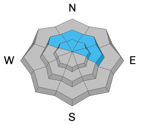
Areas of CONSIDERABLE danger exist on above treeline slopes that face north through east. On these slopes, you can trigger large, destructive hard slab avalanches failing on a buried persistent weak layer. A MODERATE danger for this type of avalanche exists on all other northerly facing slopes near tree line and above. Travel advice is to stick to low-angle slopes to avoid this problem.

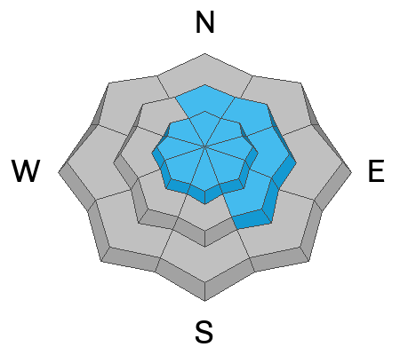
There is a MODERATE danger of triggering an avalanche in recent soft slabs and older hard slabs of wind-drifted snow. This problem is most pronounced above treeline today, as last night's strong north winds have whipped up a fresh round of soft slabs around the compass. Older hard wind slabs are still a hazard on leeward slopes near treeline.

Low
Moderate
Considerable
High
Extreme
Learn how to read the forecast here
Special Announcements

Geyser Pass Road Conditions: The road was plowed on Friday.

Grooming: LUNA groomed all trails on Sunday.

We are looking to reschedule our Moab Backcountry 101 Class to February 20, 21 in the hopes that we will have more snow. Click here for information and registration. Moab and Monticello locals can use the discount code MOAB-LOCAL for a 10% discount.

Weather and Snow

24 Hour Snow: 0" 72 Hour Snow: 0" Season Total Snow: 36" Depth at Gold Basin: 23"

Winds on Pre-Laurel Peak: N 20 G 51 Temp: 30° F

Weather

Under few high clouds, it is 30°F in Gold Basin this morning. Overnight, winds out of the north blew in the strong range with extreme gusts. The highest gusts registered 51 MPH. Today the wind will continue to blow from the north, averaging 20 MPH with gusts up to 30 MPH. Daytime highs will reach 36°F, and skies will be clear. There isn't much to discuss regarding the weather this week. Warm days and cool nights, along with dry conditions, are expected to continue through the seven-day forecast, with high pressure remaining centered just to our west.

General Conditions

I toured the Laurel Highway and skied down into Gold Basin yesterday, covering a variety of aspects and elevations. I found decent turning in dense sun-affected snow on the solar aspects where there is less avalanche hazard. I also found good turns on sheltered northerlies, but shallow conditions warrant skiing with caution near and below treeline. We just can't seem to get a break from the strong north winds, and sheltered slopes will be the name of the game today if you are searching for powder turns. Another batch of soft wind slabs is the result of last night's strong winds. Expect to find recent soft slabs of wind-drifted snow on all aspects above treeline. Avalanches failing on a buried persistent weak layer remain a serious concern as the entire snowpack underneath is loose, weak, and faceted beneath the Christmas rain crust.

Snowpack and Weather Data

Gold Basin SNOTEL site (10,000')
SNOTEL site near Geyser Pass Winter Trailhead (9600')
Wind Station on Pre-Laurel Peak (11,400')
NWS forecast for the La Sal Mountains.
Recent Avalanches
A large snowmobile-triggered avalanche occurred on the East Face of Laurel Peak on Friday afternoon. Eric and I went up on Saturday to have a look. What we found is in the video below. A full accident report has been published here.

Also check out this incredible drone footage shot by pro observer Chris Benson who joined us up there Saturday.

Click here for the complete avalanche database.
Avalanche Problem #1
Persistent Weak Layer
Type
Location
Likelihood
Size
Description

Poor snowpack structure remains, and it has proven capable of producing large, destructive human-triggered avalanches. Friday’s avalanche failed on the weak layer beneath the Christmas rain crust. In some locations, this crust may temporarily support the weight of a skier or rider, but its ability to bridge underlying weaknesses is highly variable and unreliable. The most dangerous slopes are above treeline and face north and east, especially those that harbor a more robust slab from previous wind loading. My observation from yesterday is worth a read, as I give an in-depth discussion on the current setup.

The snowpack will not offer much feedback today. Outward signs of instability have decreased, and snowpack tests are stubborn at best. These are challenging conditions to assess in the field, making it difficult to confidently move into steeper, consequential terrain. When the snowpack is confusing, terrain choice becomes critical—sticking to low-angle slopes remains the safest option for skiing and riding.

Avalanche Problem #2
Wind Drifted Snow
Type
Location
Likelihood
Size
Description
Today, you can expect both recently formed soft wind slabs and older, more cohesive hard slabs near and above treeline. Last night's strong north winds will result in sensitive soft slabs around the compass above treeline. Newer wind slabs are often sensitive and may be triggered remotely. Atypical wind directions can create unusual and complex loading patterns. As a result, wind-drifted snow may be present on a wide range of aspects above treeline due to cross-loading.
Near treeline, older hard slabs of wind-drifted snow are still in play. While I think these will be more stubborn to trigger, it will still be possible today. Because of their stubborn nature, older, hard slabs may not release until a rider is well onto the slab. Pay close attention to and avoid wind drifts on gully walls, below cliff bands, along sub-ridges, and in terrain features such as scoops, saddles, and depressions.
Any avalanche triggered in wind-drifted snow has the potential to step down to buried persistent weak layers, causing a deeper and more dangerous avalanche.
Additional Information
General Announcements
This forecast is from the U.S.D.A. Forest Service, which is solely responsible for its content. This forecast describes general avalanche conditions and local variations always occur.