Forecast for the Moab Area Mountains

Eric Trenbeath
Issued by Eric Trenbeath on
Saturday morning, January 10, 2026

Although not widespread, areas of CONSIDERABLE avalanche danger exist on steep, wind loaded slopes at and above tree line that face N-NE-E. In these areas large and dangerous, human triggered avalanches failing on a buried persistent weak layer are likely. A MODERATE avalanche danger for this type of avalanche exists on all other northerly facing slopes near tree line and above. Avoiding slopes steeper than 30 degrees in these areas is the only way to avoid this problem.

A MODERATE avalanche danger exists for human triggered avalanches involving recent deposits of wind drifted snow. This danger may be found on all aspects above tree line, and on near tree line slopes facing N-NE-E-SE. Wind drifts are recognizable by their smooth rounded appearance and cracking is a sign of instability. Avoid steep slopes that have recent deposits of wind drifted snow.

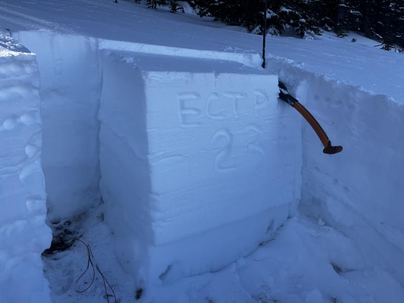
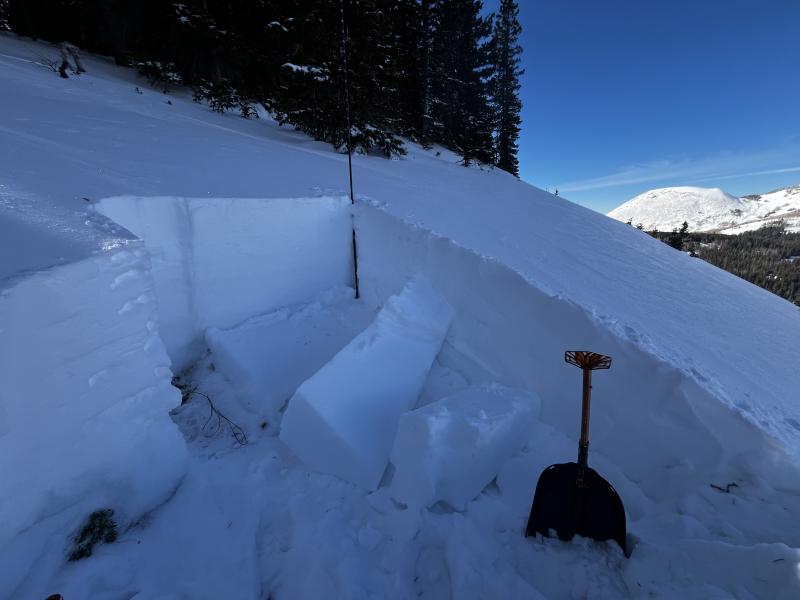
Conditions remain thin and hazards such as rocks and logs are thinly covered.

Low
Moderate
Considerable
High
Extreme
Learn how to read the forecast here
Special Announcements

Geyser Pass Road Conditions: The road was plowed on Friday.

Grooming: LUNA groomed all trails yesterday.

We are looking to reschedule our Moab Backcountry 101 Class to February 20, 21 in the hopes that we will have more snow. Click here for information and registration. Moab and Monticello locals can use the discount code MOAB-LOCAL for a 10% discount.

Weather and Snow

24 Hour Snow: 0" 72 Hour Snow: 4" Season Total Snow: 36" Depth at Gold Basin: 24"

Winds on Pre-Laurel Peak: NW 15-20 Temp: 7° F

Weather

An extended period of high pressure begins to build over the region. High temperatures at 10,000 feet will be in the low 20's today. Winds blowing from the northwest will back off and swing to the southwest averaging 10-15 mph along ridge tops.

General Conditions

Storm totals from Thursday measured 4-6 inches of low density powder bringing us up to around 16 inches at a little over 2.5 inches of snow water equivalent since the new year. Strong winds averaging 25-30 mph with gusts to 40 mph yesterday afternoon blew from the northwest sending huge plumes of snow off the peaks and drifting snow on to leeward slopes. The snow from the past week has formed a cohesive slab over top of the Christmas rain crust and the entire snowpack underneath is loose, weak, and faceted creating a perfect recipe for avalanches. Wind drifted snow has exacerbated the problem. In sheltered areas, snow depths range from about 24 inches at 10,000 feet to up to 3 feet or more at upper elevations.

Snowpack and Weather Data

Gold Basin SNOTEL site (10,000')
SNOTEL site near Geyser Pass Winter Trailhead (9600')
Wind Station on Pre-Laurel Peak (11,400')
NWS forecast for the La Sal Mountains.
Recent Avalanches
We received a report of a large, snowmobile triggered avalanche that resulted in a partial burial in Dark Canyon yesterday. The slide occurred on a steep, easterly aspect above 11,000 feet. Dave and I will be headed over there today to gather more information.
Click here for the complete avalanche database.
Avalanche Problem #1
Persistent Weak Layer
Type
Location
Likelihood
Size
Description

The poor snowpack structure has proven that it is capable of producing large and dangerous, human triggered avalanches. Stability tests continue to produce stubborn results and knowing exactly where you are going to trigger a dangerous avalanche is tricky. The likelihood of triggering an avalanche largely depends on the strength and thickness of the rain crust, and the amount of recent wind loading which seems to be a key factor in yesterday's avalanche. Avoiding north and easterly facing slopes steeper than 30 degrees is the only sure way to avoid this problem and I'd recommend doing so, your life may depend on it.

Results of an extended column test on NE aspect around 11,000 feet on Tuesday. Note the thickness of the slab failing on a deeply buried, faceted weak layer near the ground. I found similar results yesterday. An avalanche of this size and depth would be very dangerous.

Avalanche Problem #2
Wind Drifted Snow
Type
Location
Likelihood
Size
Description
Strong winds blowing from the northwest have redistributed snow and formed potentially unstable drifts on virtually all aspects above tree line, and on slopes with an easterly component near tree line. Although the prevailing pattern from north winds is to deposit snow on to leeward south and easterly aspects, the nature of the terrain here makes it very susceptible to cross loading and we often see wind loading on northerly aspects as well. Look for fresh drifts on the leeward sides of ridge crests and terrain features such as gully walls and sub ridges. On west through north aspects, fresh drifts may form adjacent to bare ground, with a variation in terrain making all the difference. Suspect steep slopes that have have a smooth, rounded appearance or that sound or feel hollow underneath. Cracking is a sign of instability.
Additional Information
General Announcements
This forecast is from the U.S.D.A. Forest Service, which is solely responsible for its content. This forecast describes general avalanche conditions and local variations always occur.