Forecast for the Logan Area Mountains

Paige Pagnucco
Issued by Paige Pagnucco on
Saturday morning, March 21, 2026

Record heat is creating CONSIDERABLE avalanche danger in the backcountry. Expect dangerous wet avalanche conditions, with natural loose and wet slab avalanches possible and human-triggered avalanches likely on many slopes steeper than 30 degrees.

Make cautious choices, evaluate snow and terrain carefully, and avoid travel on or under steep slopes with melt-softened saturated snow.

Low
Moderate
Considerable
High
Extreme
Learn how to read the forecast here
Special Avalanche Bulletin

We have issued a Special Avalanche Bulletin for all mountain regions across Utah and southeastern Idaho through Sunday, March 22.

Record-breaking warm temperatures will rapidly destabilize the snowpack across the state, increasing the likelihood of widespread, spontaneous, destructive wet avalanches. Wet avalanches could occur on all aspects and at all elevations, including places that typically stay colder this time of year. Avoid travel on and below steep slopes, including avalanche runout zones and terrain traps.

Special Announcements

Spring Campaign and Spring Auction - Each spring, we ask for your continued financial support to fund our forecasting and education programs. We hope you will consider supporting our mission by checking out our campaign and auction, live and available HERE.

Weather and Snow

We rode around the Tony Grove area yesterday in the heat of the day and found variable supportability. The snow in places was punchy, dropping the front end down about a foot into the wet snow. It was strange to seek shade as the sun and heat were almost unbearable, especially in south-facing terrain. Conditions should be more supportable, at least this morning, as the clear night allowed for radiant heat loss. The high sun angle and record-breaking warm temperatures will quickly soften up the snow, though.
In northerly terrain, the intense heat could cause dangerous slab avalanches to fail naturally on a buried persistent weak layer, and natural wet slab and loose avalanches entraining wet snow are possible on slopes steeper than 30 degrees at all elevations. Except for north-facing slopes and shady canyon bottoms, the snow has completely melted off most terrain below about 7000 feet in the Logan zone.

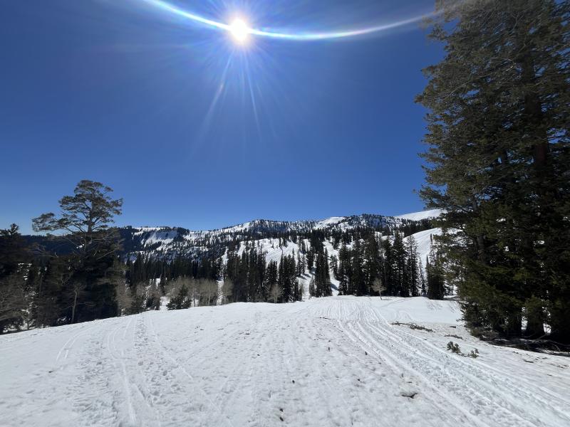
The snow surface is very dirty and rough in most places. Yesterday, it felt more like May in the mountains.

It's still way too warm: The UAC Card Canyon weather station at 8700 feet reports a toasty 54°F and 48 inches of total snow. It's also 50°F at the Tony Grove Snotel at 8400', with 58 inches of total snow. At 9700 feet on Logan Peak, winds are blowing from the southwest at 26 mph. And at 0600, it's already 49°F on Paris Peak at 9500 feet! The winds are from the south-southwest, 20 to 25 mph. Mountain temperatures will climb to almost 60°F again this afternoon, while temperatures in Cache Valley will be near 80°F. Winds blowing from the west will pick up during the day, gusting into the mid 30s mph, which may help keep you from overheating. A dry, cold front moves through the zone overnight into Sunday, dropping temperatures only about 10 to 15°F. The reprieve is short-lived as un-March-like warmth builds back in by early to mid-week.

With dangerous wet avalanche conditions, avoiding travel in avalanche terrain is the obvious best choice. And with marginal backcountry riding conditions on slushy, dusty, punchy snow, this weekend's plans might include more favorable warmer-weather activities like fishing, gardening, golfing, climbing, biking, hiking, trail running, picnicking, boating, or perhaps just taking a nap.

Coverage is still good, though the snow is dirty and covered in debris in some areas after last weekend's strong and dusty wind event.

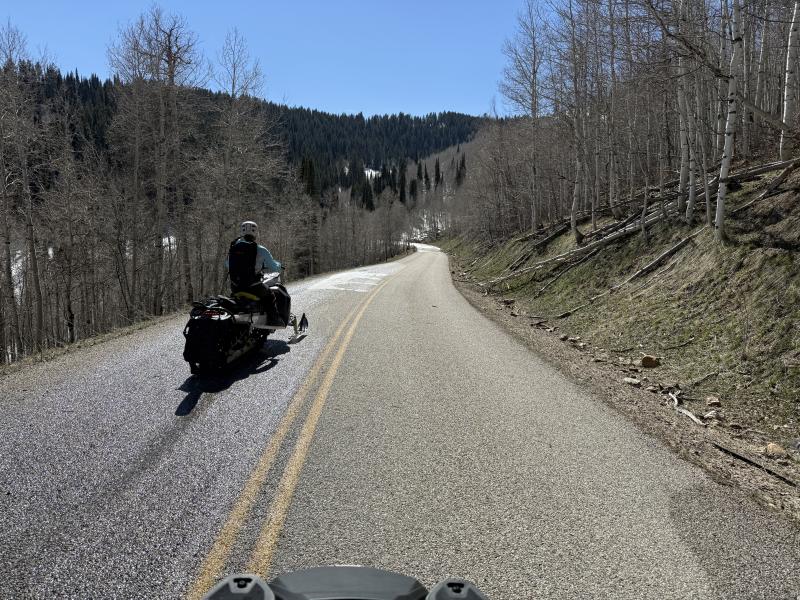
Access is getting challenging.

Recent Avalanches

Yesterday, we observed recent natural wet activity on sunny slopes in the Tony Grove and Mt Naomi areas.

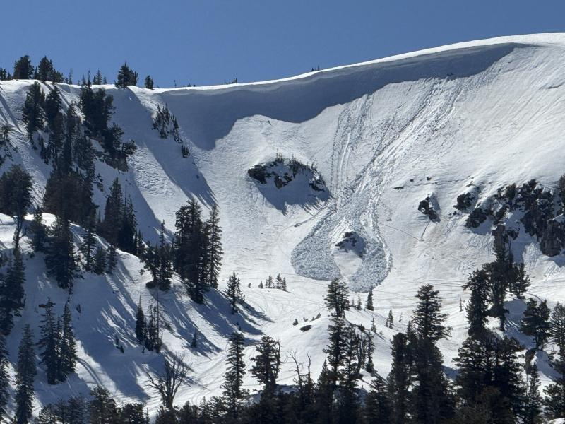
A natural, loose wet avalanche occurred yesterday afternoon on Grandfather Cornice.

Find observations from the Logan Zone and from across the state HERE.

Avalanche Problem #1
Wet Snow
Type
Location
Likelihood
Size
Description

After another unusually toasty night, daytime heating will keep wet avalanche conditions elevated. Loose wet avalanches capable of entraining large amounts of saturated snow are expected in very steep, rocky terrain, while the likelihood of more hazardous wet slab avalanches continues to increase.

  • Pay attention to terrain traps below you, such as gullies or cliffs, where even a small avalanche can have severe consequences.
  • If you're sinking into the snow above your ankles, or you're seeing active roller balls, move to shadier or lower-angle terrain.
  • Avoid being on or under steep slopes with saturated surface snow and poor snow structure.

An example of what we are talking about when we mention wet slab avalanches.

Avalanche Problem #2
Persistent Weak Layer
Type
Location
Likelihood
Size
Description

Meltwater is percolating through the snowpack and actively weakening the hard layers above the January persistent weak layer, increasing the potential for large, natural, heat-induced avalanches. As these slab layers soften, it becomes easier for a person to trigger a dangerous avalanche.

Additional Information

Toby checked out the Bloomington Canyon zone on Thursday ...

  • Travel with a partner, and cross or ride slopes steeper than 30 degrees one at a time while the rest of your group watches from a safe spot.
  • Ensure that everyone in the group has avalanche rescue equipment (a transceiver, probe, and shovel) and knows how to use it.

-----------------------------------------------------------------------------------------------------------------------------------------------------------------

For all questions on forecasts, education, Know Before You Go, events, online purchases, or fundraising, call 801-365-5522.

Did you know the UAC hosts a podcast? Episode 2 of Season IX is just out - AI, Machine Learning, and the Value of Expert Intuition at the Utah Avalanche Center.

Are you interested in learning more about avalanches? Visit our education page for details on all our classes.

For more information, visit the UAC weather page here: UAC Weather Page For Logan-specific weather, go here: Logan Mountain Weather

-Remember, the information you provide could save lives, especially if you see or trigger an avalanche. To report an avalanche or submit an observation from the backcountry, go HERE

-Receive forecast region-specific text message alerts to receive messages about changing avalanche conditions, watches, and warnings. Sign up and update your preferences HERE

This forecast is from the U.S.D.A. Forest Service, which is solely responsible for its content. This forecast describes general avalanche conditions and local variations always occur.

General Announcements
This information does not apply to developed ski areas or highways where avalanche control is normally done. This forecast is from the U.S.D.A. Forest Service, which is solely responsible for its content. This forecast describes general avalanche conditions and local variations always occur.