Forecast for the Logan Area Mountains

Toby Weed
Issued by Toby Weed on
Friday morning, March 20, 2026

Record heat will cause CONSIDERABLE avalanche danger in the backcountry today. Expect dangerous wet avalanche conditions, with natural loose and wet slab avalanches possible and human-triggered avalanches likely on many slopes steeper than 30 degrees.

Make cautious choices, evaluate snow and terrain carefully, and avoid travel on or under steep slopes with melt-softened saturated snow.

Low
Moderate
Considerable
High
Extreme
Learn how to read the forecast here
Special Avalanche Bulletin

A Special Avalanche Bulletin is issued for all mountain regions across Utah and southeastern Idaho through Sunday, March 22.

Record-breaking warm temperatures will rapidly destabilize the snowpack across the state, increasing the likelihood of widespread, spontaneous, destructive wet avalanches. Wet avalanches could occur on all aspects and at all elevations, including places that typically stay colder this time of year. Avoid travel on and below steep slopes, including avalanche runout zones and terrain traps.

Special Announcements

Spring Campaign and Spring Auction - Each spring, we ask for your continued financial support to fund our forecasting and education programs. We hope you will consider supporting our mission by checking out our campaign and auction, live and available HERE.

Weather and Snow

Once again, overnight low temperatures stayed well above freezing, from the valley floors to the highest mountain tops. Radiation heat loss from clear skies created a thin, superficial crust on the dusty snow surface that will probably be supportable in many areas, but the snow on most slopes will quickly soften up in today's hot sun. Melt will continue to percolate into the winter snowpack, saturating and loosening the snow, and elevating avalanche danger on slopes facing all directions. On Thursday in Bloomington Canyon, I found isothermic, melt-softened snow. My snowpit tests in southerly terrain near Paris Peak indicated that a wet slab could propagate where melt was pooling on a solid crust, creating a slushy weak layer. Here is the report. In northerly terrain, the intense heat could cause dangerous slab avalanches to fail naturally on a buried persistent weak layer, and natural wet slab and loose avalanches entraining wet snow are possible on slopes at all elevations steeper than 30 degrees. Except for north-facing slopes and shady canyon bottoms, the snow has completely melted off most terrain below about 7000 feet in the Logan Zone.

The snow surface is very dusty and patterned in wind-exposed areas at upper elevations.

It's way too warm: The UAC Card Canyon weather station at 8700 feet reports a toasty 48°F and 51 inches of total snow. It's also 48°F at the Tony Grove Snotel at 8400', with 61 inches of total snow. At 9700 feet on Logan Peak, winds are blowing from the west 15 to 28 mph. And at 0600, it's already 46°F on Paris Peak at 9500 feet! The winds are from the west-southwest, 17 to 25 mph. Mountain top temperatures will climb to around 60°F again this afternoon, while temperatures in Cache Valley will be near 80°F. Tonight, mountain temperatures will remain well above freezing again, and tomorrow will be mostly sunny and about as warm as it is today. With dangerous wet avalanche conditions, avoiding travel in avalanche terrain is the obvious best choice. And with marginal backcountry riding conditions on slushy, dusty snow, this weekend's plans might include warmer-weather activities like gardening, golfing, climbing, or biking.

Temps at the 8400' Tony Grove Snotel are hovering a bit below 50°F this morning.

Recent Avalanches

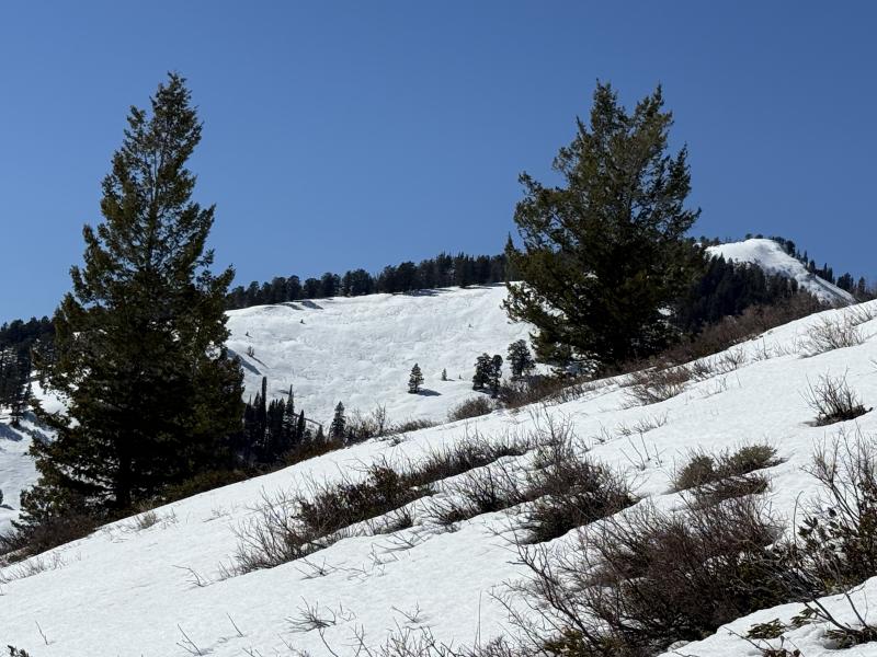
Yesterday, we observed recent natural wet activity on sunny slopes in the Wellsvilles, Woodcamp, and the Northern Bear River Range.

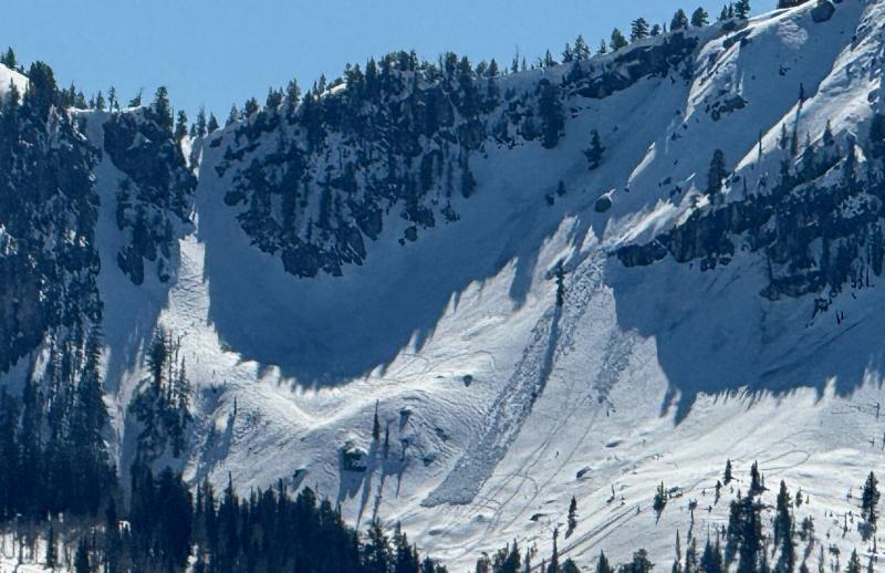
A natural loose wet avalanche covers recent tracks near Bloomington Lake.

Find observations from the Logan Zone and from across the state HERE.

Avalanche Problem #1
Wet Snow
Type
Location
Likelihood
Size
Description

After another very warm night, today's summer-like heating will elevate wet avalanche conditions another notch, and dangerous avalanche conditions will likely develop. Loose wet avalanches entraining large piles of saturated snow are likely in very steep rocky terrain, and more dangerous wet slab avalanches are becoming increasingly possible.

  • Pay attention to terrain traps below you, such as gullies or cliffs, where even a small avalanche can have consequences.
  • If you're sinking into the snow above your ankles, or you're seeing active roller balls, relocate to shadier or lower-angle terrain.
  • Avoid being on or under steep slopes with saturated surface snow and poor snow structure.
Avalanche Problem #2
Persistent Weak Layer
Type
Location
Likelihood
Size
Description

The melt, as it percolates through the snow, is softening the hard layers above the January persistent weak layer, and large natural heat-induced avalanches are possible. As the slab layers soften, it could also become easier for a person to trigger a dangerous avalanche.

Additional Information
  • Travel with a partner, and cross or ride slopes steeper than 30 degrees one at a time while the rest of your group watches from a safe spot.
  • Ensure that everyone in the group has avalanche rescue equipment (a transceiver, probe, and shovel) and knows how to use it.

-----------------------------------------------------------------------------------------------------------------------------------------------------------------

For all questions on forecasts, education, Know Before You Go, events, online purchases, or fundraising, call 801-365-5522.

Did you know the UAC hosts a podcast? Episode 2 of Season IX is just out - AI, Machine Learning, and the Value of Expert Intuition at the Utah Avalanche Center.

Are you interested in learning more about avalanches? Visit our education page for details on all our classes.

For more information, visit the UAC weather page here: UAC Weather Page For Logan-specific weather, go here: Logan Mountain Weather

-Remember, the information you provide could save lives, especially if you see or trigger an avalanche. To report an avalanche or submit an observation from the backcountry, go HERE

-Receive forecast region-specific text message alerts to receive messages about changing avalanche conditions, watches, and warnings. Sign up and update your preferences HERE

This forecast is from the U.S.D.A. Forest Service, which is solely responsible for its content. This forecast describes general avalanche conditions and local variations always occur.

General Announcements
This information does not apply to developed ski areas or highways where avalanche control is normally done. This forecast is from the U.S.D.A. Forest Service, which is solely responsible for its content. This forecast describes general avalanche conditions and local variations always occur.