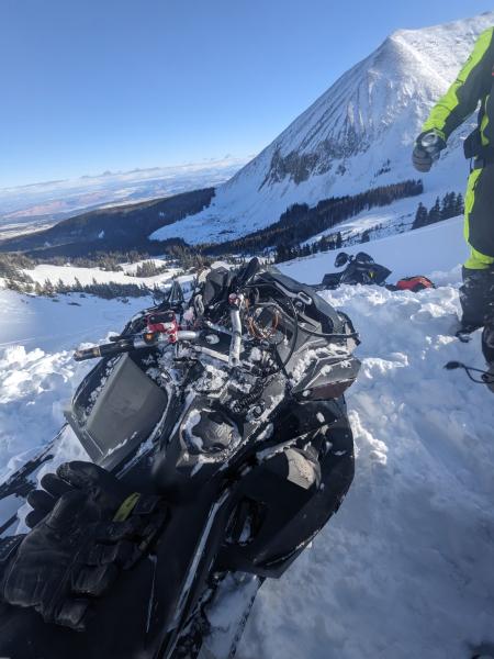
On the evening of January 9, 2026 we received a report of a large snowmobile triggered avalanche in Dark Canyon. One rider had been caught, carried, and almost completely buried but had his hands and head sticking out. His three companions who were waiting below hurried up to dig him out. All were carrying proper rescue gear and the victim was wearing an airbag that he said he was unable to reach.
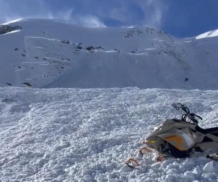
Another rider in the party had made tracks to the observer's right of the slope where it changes aspect at a gully and tilts to the south. The victim was the first rider on the slope that avalanched. He reported riding up a few hundred feet above where he was eventually buried before turning back down slope where he was hit from behind. He said he was carried for about 100 feet.
The incident occurred in a high alpine bowl in upper Dark Canyon on the east face of Mount Laurel (12,270'). The greater basin is flanked by Mount Mellenthin (12,638') to the north and Mount Peale (12,720') to the south. It is characteristic La Sal alpine terrain, steep, rocky, and above tree line.

It's been a very lean season to date, and the La Sal Mountains have only received 36 inches of snow at the Gold Basin Study Plot (10,000'). A mid-November storm brought 10 inches with another 10 inches falling on November 30. No snow fell during the month of December, and the snowpack began to facet and weaken. By mid-month, record warm temperatures began to reverse the process, and we were seeing F+ to 4f rounding faceted layers and a nearly isothermal snowpack. South aspects turned bare. On Christmas Day, 0.5 inches of rain fell at Gold Basin, with rain up to at least 11,700 feet. This left a crust of varying strength and thickness, but it was largely supportable and connected a lot of terrain.
On New Year's Eve and into New Year's morning, the mountains picked up 10 inches of snow at 2.3 inches of Snow Water Equivalent (SWE). No natural activity was observed, and collapsing of the snowpack was minimal with only a few isolated reports. Neither forecaster Dave Garcia nor myself observed any over the course of the following week. The New Year's storm had formed a cohesive, 4f slab over the rain crust but extended column tests performed during the week scored ECTX to ECTP23.
Between Jan 8-9, 4 inches of low density snow fell at the Gold Basin study plot. Moderate to strong winds blew from the northwest in the early morning hours before backing off. They picked up again right around noon blowing strong for the remainder of the day with large plumes of wind transported snow visible off some, but not all of the peaks. Mount Mellenthin in particular had a huge flag, and it blew snow right through the saddle that divides Horse Creek from Dark Canyon, depositing it right on to the E and SE slopes of Laurel Mountain as seen in the video below.
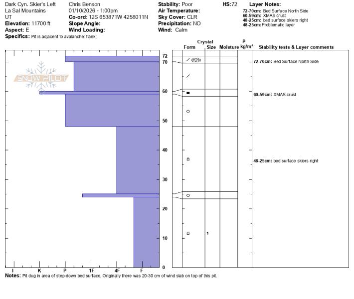
Dave Garcia and I took a profile on the right flank where the fracture was 2'-3' deep. Looking up high one area of the fracture looked to be 4' deep or more. The slope was facing 88 degrees east with a slope angle of 34 degrees. It's likely steeper higher up. In this location a pencil hard slab had failed on facets below the rain crust.

Chris Benson took a profile over on the left side near where the rider had triggered the slide. He dug next to the surface wind slab that we believe served as the initial failure. Overall, the bed surface showed several steps down with some areas where the avalanche took out facets down to the ground.
The avalanche danger rating for the day was moderate with a bottom line statement that noted "Northwest winds today will create slabs of wind drifted snow on all aspects at and above tree line. Some drifting may occur near tree line and below," as well as "Deeper and more dangerous avalanches involving a persistent weak layer remain possible near tree line and above on slopes facing NW-N-NE-E."
It seems that both avalanche problems called for in the forecast contributed to this incident, and it is our belief that the avalanche initially released in an area of wind deposited snow on the left side before stepping down into buried facets beneath the December rain crust and propagating across the slope. Although the forecast called for the possibility of deeper avalanches failing on a persistent weak layer, the size and scale of this avalanche is arresting, particularly in light of how little snow we've had this season. We are very happy that it ended positively as it easily could have had a very different outcome. Thanks to the party for reporting this accident to the Utah Avalanche Center.
Below is a video of our field investigation as well as drone footage provided by pro observer Chris Benson who's assistance was greatly appreciated.


