Forecast for the Uintas Area Mountains

Mark Staples
Issued by Mark Staples on
Saturday morning, January 23, 2021
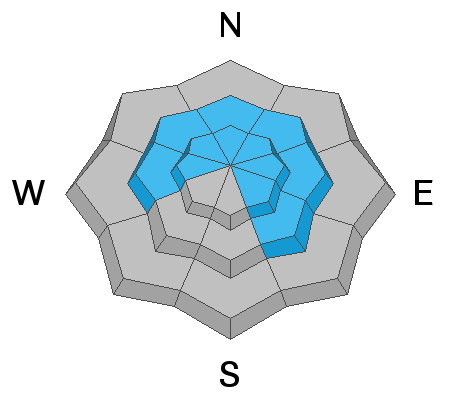
Today the avalanche danger is HIGH on upper elevation slopes and CONSIDERABLE at mid elevations. The snowpack on nearly all slopes became very weak during long periods of dry weather and both natural and human triggered avalanches are likely today. Don't even go near or underneath steep slopes today.
The avalanche danger is MODERATE at low elevations where there is just less snow. Avalanches are definitely possible in these areas but will be smaller and not as widespread.

Fortunately, the Uinta mountains are blessed with many low angle slopes (less than 30 degrees in steepness) where avalanches won't happen as long as there is nothing steep above you. These low angle slopes and open meadows are the places to ride today.
Low
Moderate
Considerable
High
Extreme
Learn how to read the forecast here
Avalanche Warning
THE UTAH AVALANCHE CENTER HAS ISSUED AN AVALANCHE WARNING FOR THE MOUNTAINS OF NORTHERN UTAH INCLUDING THE MOUNTAINS NEAR LOGAN, OGDEN, SALT LAKE CITY, AND PROVO AND THE WESTERN UINTA MOUNTAINS.
RECENT HEAVY SNOW WAS DEPOSITED ON A VERY WEAK SNOWPACK AND HAS CREATED WIDESPREAD AREAS OF UNSTABLE SNOW. BOTH HUMAN TRIGGERED AND NATURAL AVALANCHES ARE LIKELY.
STAY OFF OF AND OUT FROM UNDER SLOPES STEEPER THAN 30 DEGREES.
Special Announcements
Weather and Snow
Nowcast-
As of 5 a.m. most weather stations were reporting about 4-8 inches of snow (0.4-0.6 inches of water), but many of these are likely under-reporting and I suspect there is already 10-12 inches at many upper elevation locations especially on the southern part of the range. South winds have been suprisingly light and blowing 5-10 mph gusting 10-20 at upper elevations. Temperatures range from the upper teens to low 20s F.
Forecast-
Snow should continue for most of the day with the heaviest snowfall this morning bringing another 4-5 inches. Winds should increase some late morning or near midday and blow about 20 mph which is the perfect speed to drift snow onto northerly facing slopes. Cold air will move over the area and temperatures should slowly drop today into the low to mid teens F.
Futurecast-
Temperatures will drop into the single digits F tonight, and snowfall should taper off by early tomorrow morning. Sunday should be partly sunny, but don't let that fool you into thinking that conditions are any less dangerous. Even if the weather is nice, the snowpack is still mean.

Looking for real-time temps, snow, or wind?
Click here and then on the "western Uinta" tab for western Uinta specific, weather station network.
Recent Avalanches
No avalanches were reported yesterday, but we expect to hear about many avalanches today. On Thursday Ted rode near Elizabeth Pass and found an avalanche that likely occurred early this week when very strong winds transported snow and overloaded the weak, shallow snowpack. Read his full observation HERE.

Check here for other trip reports and avalanche observations.
Ad
Avalanche Problem #1
Persistent Weak Layer
Type
Location
Likelihood
Size
Description
It's a simple formula today: weak, rotten snowpack + new snow = avalanches. The snowpack showed signs of being unstable before this storm and it will definitely be unstable today.
The new snow will feel light and fluffy on top, but contains about an inch of water which is enough weight and stress to cause avalanches that break several feet deep and possibly 100-200 feet wide. These soft slab avalanches will fail on one of many persistent weak layers of faceted snow in the snowpack (see the photo below). There are three things that will make the situation dangerous and deceiving:
  1. You may not see many clues that conditions are dangerous becuase I don't expect many natural avalanches unless the wind increases.
  2. You won't have to be on a steep slope to trigger a slide. Just being near or under a steep slope will be enough to cause an avalanche. The other deceptive thing about this situation is that you may see several sets of tracks on a slope and think it is safe, but it could easily be the 3rd or 4th or 5th person that triggers an avalanche.
  3. Strong winds early last week created many dense, hard drifts now hidden under the new snow. These hard drifts of snow will make it harder to trigger an avalanche until you hit the right spot on a slope. The resulting avalanche will be a thick, hard slab
Photo clearly showing persistent weak layers buried in the snowpack.
Video describing how you can trigger avalanches from below.
Avalanche Problem #2
New Snow
Type
Location
Likelihood
Size
Description
The new snow may avalanche by itself as a soft slab or just a dry loose avalanche without breaking on old layers of snow described above. It fell on a variety of surfaces that included wind scoured snow, crusted snow, wind deposited snow, and even a fragile layer of surface hoar (which is frost that forms on the snow surface - see the photo below). In some places the new snow may have a good bond while in many others it may not and produce a small avalanche.
Photo of fragile surface hoar crystals on Thursday near Gold Hill.
Additional Information
This video is a 9 minute briefing of what to expect this weekend and how to travel.
Craig will update this forecast by 7:00 AM tomorrow, Sunday January 24th.
Your observations are import, so please let me know what you're seeing... click HERE and contribute to this amazing community based program
General Announcements
If you see or trigger an avalanche or just wanna let me know what you're seeing you can reach me directly at 801-231-2170 or [email protected]
This forecast is from the U.S.D.A. Forest Service, which is solely responsible for its content. This forecast describes general avalanche conditions and local variations always occur.