Forecast for the Logan Area Mountains

Paige Pagnucco
Issued by Paige Pagnucco on
Monday morning, November 30, 2020
There is LOW avalanche danger in the backcountry and avalanches are unlikely. Avoid travel on very steep drifted slopes. Use normal caution, avoid going too fast, maintain control, and be conservative.
  • Inspect and practice with your avalanche rescue equipment. Force your backcountry partners to practice with you.
Low
Moderate
Considerable
High
Extreme
Learn how to read the forecast here
Special Announcements
Utah State University Outdoor Programs is hosting a FREE Know Before You Go avalanche awareness presentation (via ZOOM) on Wednesday Dec 2 at 7pm. Pre-register here.
The holiday season is right around the corner!! Looking for that special something for your partner?
Well, we've got an easy shopping solution for you ...Buy your gifts at our Pray for Snow online auction and support the UAC in Logan. HERE
Visit this website with information about Responsible Winter Recreation by the Utah Office of Outdoor Recreation.
If you missed the 13th Annual Utah Snow and Avalanche Workshop, the recordings are available for purchase from the UAC Store.
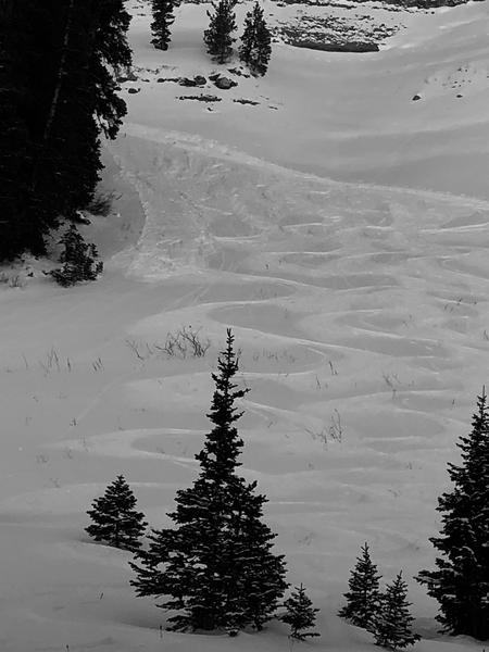
 HERE
Weather and Snow
There's a small chance for a few flurries tonight but the forecast for the upcoming week continues to show a mostly dry and sunny weather pattern. Very shallow early season snow conditions persist in the Logan Zone. At high elevations there is a shallow layer of surface hoar and near surface facets sitting on top of a mostly supportable crust. Riding conditions are pretty decent in low angle terrain. Snowpack depths average about 40-60 cm up high with Tony Grove Snotel reporting 95% of normal SWE (Snow Water Equivalent).
What you see is what you get, and hitting rocks or other shallowly buried obstacles presents a significant hazard. Today will be sunny in the mountains with temps near 30F. The next weather disturbance will track across northern Utah and southwest Wyoming Monday night through early Tuesday, bringing cooler temperatures beginning midweek.
Hoar frost develops when nights are clear and cold. (pc: Jeremy Jensen)
Ad
Avalanche Problem #1
Normal Caution
Type
Location
Likelihood
Size
Description
Potential for triggering small loose avalanches or slabs of drifted new snow may be found on extreme or very steep, upper elevation slopes, and people could trigger avalanches. Increasing winds today may drift recrystallized surface snow into shallow slabs on some upper elevation slopes.
  • Even a small avalanche could be very dangerous due to shallow early season snow conditions. You do not want to get caught and carried over rocks or strained through bushes and stumps, so it's best to avoid travel on all steep drifted slopes.
  • Now is a great time to dig out your avalanche rescue gear: put fresh batteries in your transceiver, put together your shovel and probe, and practice your companion rescue skills.

Small avalanches of loose surface snow are possible on very steep slopes.

Additional Information
It’s a good idea to tone it down in the early season because it’s pretty easy to get hurt in shallow snow, and it’s absolutely the worst time to do so because you could ruin your whole season.

Everybody should make time to examine and practice with your avalanche rescue equipment, and convince your backcountry partners to practice with you.
General Announcements
The Tony Grove Road is not maintained for wheeled vehicles in the winter.
EMAIL ADVISORY. If you would like to get the daily advisory by email you subscribe HERE.
Remember your information can save lives. If you see anything we should know about, please help us out by submitting snow and avalanche observations....HERE. You can also call us at 801-524-5304, email by clicking HERE, or include #utavy in your tweet or Instagram.
Toby will update this advisory by around 7:30 Wednesday morning.
This forecast is from the USDA Forest Service, which is solely responsible for its content. The forecast describes general avalanche conditions and local variations always occur.