Forecast for the Uintas Area Mountains

Craig Gordon
Issued by Craig Gordon on
Sunday morning, April 5, 2020
In an overall sea of green, at and above treeline in the wind zone, pockets of MODERATE avalanche danger exist on wind drifted slopes. Human triggered avalanches are POSSIBLE on steep, leeward slopes facing the north half of the compass, particularly those with an easterly component to its aspect. Any avalanche triggered is gonna pack a punch and could easily ruin your day.
Your risk reducing exit strategy is this- good riding with more predictable avalanche danger is found with some loss of elevation. Wind sheltered mid and low elevation terrain offers generally LOW avalanche danger.
Low
Moderate
Considerable
High
Extreme
Learn how to read the forecast here
Special Announcements
Spring Awareness Campaign - Help us save lives through avalanche forecasts and education. Consider making a donation before April 8th.
We are sad to share the news of two recent avalanche fatalities:
On Wednesday, Trace Carrillo died in an avalanche on Taylor Mountain near Teton Pass. Trace was formerly an intern with the UAC and more recently a wilderness ranger with the Forest Service. Article here. Preliminary report here.
On Friday, Rob Kincaid died in an avalanche just north of Palisades Reservoir near the ID/WY stateline. Rob was well known by many snowmobilers as an athlete for Arctic Cat and veteran of many snowmobile competitions. Article here. Preliminary report here.
More details should be available soon about these tragic events but initial reports are that both men were wearing avalanche transceivers that were not turned on.

January 5, 2019 - Read this collection of 6 stories and a podcast about that day with a low avalanche danger, 8 skier-triggered avalanches, four catch and carries, a partial and critical burial, and a trip to the emergency room.
Weather and Snow
Currently-
Clouds slid through the region late last night, producing a few scattered snow showers, isolated to the high country, where an inch of new snow coats the range. Temperatures... well they've been warm overnight, hovering right around freezing, but are just beginning to cool into the high 20's as I type. Southerly winds increased early yesterday and continued ramping up overnight, currently blowing in the 30's and 40's along the high peaks. Riding and turning conditions took a hard hit yesterday and are gonna be a bit of a mixed bag today. However, if you're looking for soft settled snow, wind sheltered, upper elevation terrain is the the only game in town.
More Uinta weather network info is found here. Simply click on the Western Uinta tab.
For today-
Look for mostly cloudy skies and light snow showers throughout the day, though accumulations are gonna be minimal. High temperatures climb into upper 30's and southerly winds blow in the 40's, gusting in the 50's and 60's along the high peaks.
Futurecast-
Unsettled weather lingers tonight and starts off the workweek.
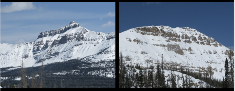
Recent Avalanches
SEE THE TREND?
Tough to identify, but common theme is... steep, rocky slopes that avalanched near the ground earlier this season and have remained thin and weak all season.
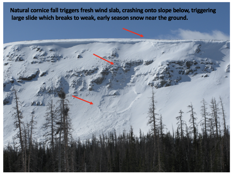
Wednesday natural avalanche in Murdock Bowl near Bald Mountain Pass. Breaking 3' deep and 200' wide, this slide would instantly ruin your day.
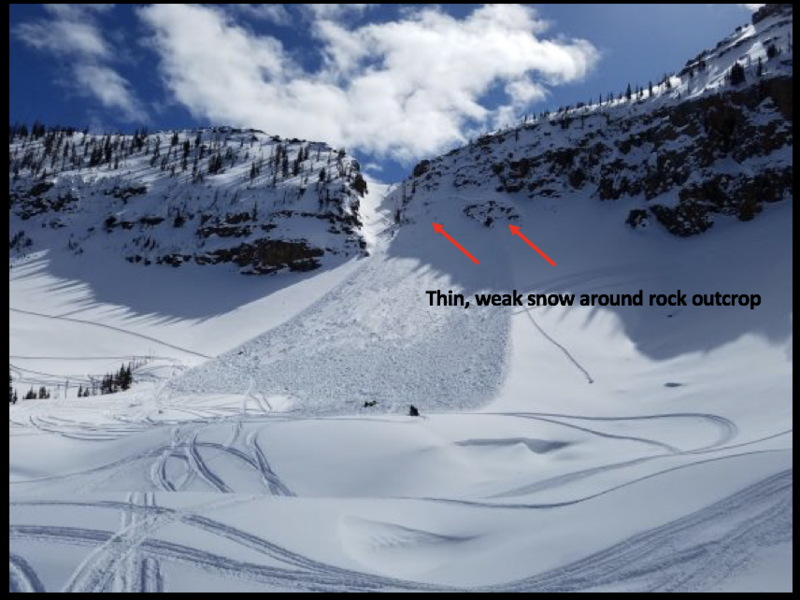
Friday human triggered avalanche on Notch Mountain-
Breaking 3' deep and a football field wide, the avalanche in the image above was triggered yesterday on the steep, heavily wind loaded, northwest facing bowl of Notch Mountain. As noted by the rider.... "I was the third snowmobiler to climb the mountain and I triggered the slide. Avalanche airbag kept my head above the snow." More details found here.
To view additional trip reports and recent avalanche activity, simply click here.
Ad
Avalanche Problem #1
Wind Drifted Snow
Type
Location
Likelihood
Size
Description
Hayden to the left of me, Bald Mountain to the right... here I am stuck in the middle with...
The Uinta's are amazing right now... fat, white and filled in. As a matter of fact, we've got a solid snowpack with a go anywhere base, which enables us to get onto big slopes and tag complex terrain. But, as you know, the Uinta's are a big range. And while the vast majority of our terrain is good to go, if you were looking to trigger an avalanche, I bet you could find one. And, recent avalanches near Bald Mountain Pass and Notch Mountain, not only illustrate the type of terrain we love to ride in the spring, it's also the type of terrain where we could trigger a slide today.
So... what to look for and what to avoid?
Fat, rounded slopes that feel or sound hollow like a drum.
The most likely suspects are gonna be isolated to the high country... steep, rocky, leeward slopes in the wind zone at and above treeline.
So, the key to riding safely today is... be flexible with your travel plans and adjust objectives if you're starting to see or feel obvious clues to unstable snow like shooting cracks, sudden collapses, or avalanches with the same terrain characteristics like the slopes you wanna ride. In addition, think about the consequences of triggering a slide, especially if you're getting into steep, technical terrain.
Additional Information
Information on outdoor recreation - The State of Utah created this webpage with information about recreating on both state and federal public lands during the current health crisis.

Skiing and riding at closed ski resorts - Some resorts allow access now, and some do not. Please check HERE for the latest info on ski area access.

New to the backcountry (including riding at closed resorts) - Watch the award-winning, 15 minute Know Before You Go video, or take the 5-part, free online-learning series.
General Announcements
The information in this forecast expires in 24 hours, but will be updated by 7:00 AM Monday Apr. 6th.
This forecast is updated daily by 7:00 AM.
In the mean-time, if you see or trigger an avalanche or just wanna let me know what you're seeing you can reach me directly at 801-231-2170
The information in this forecast is from the US Forest Service which is solely responsible for its content.