Forecast for the Uintas Area Mountains

Craig Gordon
Issued by Craig Gordon on
Saturday morning, March 7, 2026

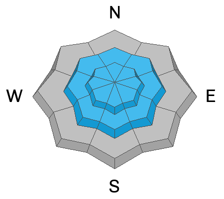
CONSIDERABLE avalanche danger exists in the wind zone at and above treeline where fresh drifts and shallow storm slabs will react to our additional weight. Human triggered avalanches are LIKELY, especially on steep, drifted, leeward slopes and particularly those with a southerly component to their aspect.

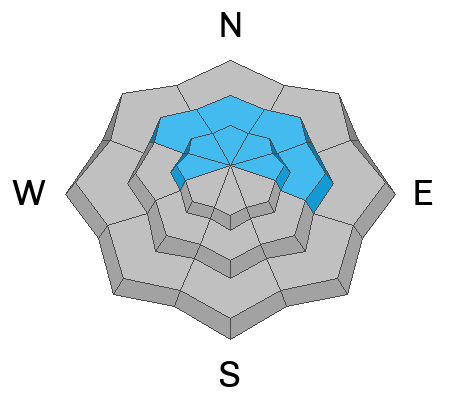
Recent winds were all over the place, finding their way into mid elevation terrain as well. While not widespread, MODERATE avalanche danger is found in terrain we generally consider sheltered. Human triggered avalanches are POSSIBLE on steep slopes with recent deposits of wind drifted snow.

Note to self... with strong spring sun in the mix, cold storm snow gets cranky as it takes on heat in a hurry today. Sustained steep slopes at all elevations may produce slides that entrain more snow than you might expect, stacking up deep piles of debris in terrain traps like gullies and road cuts.

Low
Moderate
Considerable
High
Extreme
Learn how to read the forecast here
Weather and Snow

Nowcast - Skies are clear in the wake of yesterday's storm and wow... what a storm! I totally under-forecast Friday's intent to wrap up the workweek and get the party started, and man, it went out with a bang! The eastern front lit up just after the morning commute as a moist impulse slid through the HOV lane, squeezing out 12" of snow with only .60" H2O. Storm totals hover at 20" of snow with just under an inch of SWE, delivering legit over-the-hood and over-the-head riding. Cold air settled into the region overnight and current temperatures register in the single digits °F across the board. Northerly winds blew in the 30's yesterday, but begin relaxing in the 5-15 mph range at the turn of the new day.

Forecast - It'll be a stunning day with mostly sunny skies and temperatures climbing into the mid 30's °F, while winds blow 10-25 mph from the north. Get out and get after it before the sun beats you to the punch

Futurecast - High and dry for the upcoming week.

Travel Conditions -

Trevor Katz seen here taking his snow science work seriously with a deep dive into yesterday's storm snow. 4 out of 5 forecasters surveyed say... you should been here yesterday! (The fifth forecaster surveyed prefers to travel with sunny skies overhead :)

Recent Avalanches

'Twas milk jug viz for Friday with no eyes on big slopes. In wind sheltered terrain, sluffing in the new storm snow and a few shallow wind slabs were the flavor of the day.

Avalanche Problem #1
Wind Drifted Snow
Type
Location
Likelihood
Size
Description

24 hour data dump from Windy Peak (10,662') illustrating wind trends during the recent storm, including some robust periods during yesterday mornings dump-fest.

Winds kicked in to wrap up the work week and they were all over the map, drifting snow on westerly aspects (unusual for us), lower downslope, and in peculiar places. This is a short-term avalanche problem and I suspect the majority of drifts became comfortable in their own skin overnight and won't be quite as touchy as they were yesterday. However, I bet there's a fresh wind drift or two that'll react to our additional weight, especially on steep leeward slopes, like those facing the south half of the compass. This is a very manageable avalanche dragon to identify and an equally easy one to avoid. Simply steer clear of any fat, rounded pillows of snow, especially if they feel hollow underfoot.

Avalanche Problem #2
Persistent Weak Layer
Type
Location
Likelihood
Size
Description

I don't think yesterday's storm was enough weight to irritate the January PWL. My gut feel is we're moving away from this avalanche problem (see below for a deeper dive), but rather than jumping head first into big terrain, I'm dipping a toe in the water and playing mini golf on smaller slopes similar in aspect and elevation to see how they're feeling before blindly punching an aggressive line.

Mild temps, strong spring sunshine, and a whole 'lotta water go a long way to help a snowpack begin healing and I'm psyched the January PWL is feeling some warm love from our recent storms. The good news... the snowpack is beginning to gain strength and other than a subtle whumph or two, I'm encouraged to see it adjusting to the big mid-February storm. The flake news... remember, all we need to do is find a weakness, maybe around a rock or a bush, collapse the pack, and now we're staring down the barrel of a dangerous slide.

Becoming more the exception than the rule, this is still the type of avalanche we can trigger today, if we're able to find a weakness in a thin portion of the slab and knock the legs out from underneath.

Avalanche Problem #3
New Snow
Type
Location
Likelihood
Size
Description

With strong spring-time sun overhead, fresh storm snow will become more reactive to our additional weight, especially on sustained steep slopes, even at lower elevations.

Additional Information

Join the UAC for the first "Stay and Play Avalanche Course" at Bear River Lodge in the Uintas, March 19th-22nd. This course is designed for snowmobilers by snowmobilers, where you will learn avalanche rescue, riding skills, and how to survive in the backcountry. Come enjoy all the luxury offerings at Bear River Lodge and improve your skills along the way.

Our Avalanche Rescue Training Park is set-up and located at the top of Wolf Creek Pass, SR-35, and is waiting for you to come take it for a spin! Open up the control unit, flip a few switches, and dial in your avalanche rescue skills with this roadside attraction!

General Announcements

We have some upcoming classes and events that we'd be stoked to see you at -- Please reach out with any questions and check out below for more details!

We are always looking for snow and avalanche observations or just general riding conditions. Reach out to us with questions, concerns, or if you see anything in your travels! Contact us directly through the info below:

This forecast is from the U.S.D.A. Forest Service, which is solely responsible for its content. This forecast describes general avalanche conditions, and local variations always occur. This forecast was issued on Saturday, March 07 at 0400 and expires 24 hours after it was issued. We'll update this information by 07:00 AM tomorrow.