Forecast for the Uintas Area Mountains

Craig Gordon
Issued by Craig Gordon on
Wednesday morning, March 4, 2026

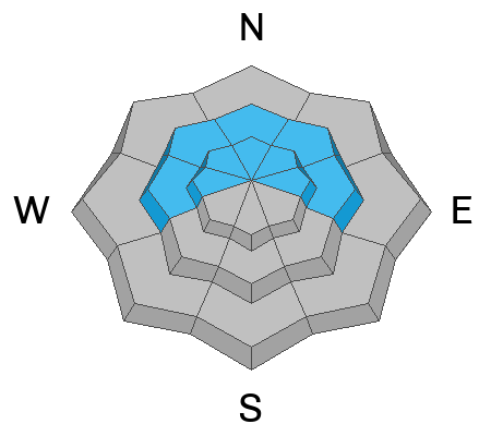
While not widespread, upper elevation polar slopes facing the north half of the compass deliver pockets of CONSIDERABLE avalanche danger and human triggered slides are LIKELY. Potentially breaking nearly 4' deep and hundreds of feet wide, today's timber-snapping, terrain-trap filling avalanches fail on weak faceted snow, may still be triggered from a distance, and are nothing to mess around with.

In the more predictable category, both fresh and older wind drifts may still react to our additional weight. In the wind zone, above treeline, you'll find MODERATE avalanche danger and human triggered avalanches are POSSIBLE on steep slopes with recent deposits of wind drifted snow.

Don't forget... Utah's strong spring sun is high in the sky and wet avalanches are a thing around here, especially during the heat of the day. If you're feeling like an ant under a magnifying glass, so is the snow and it's time to move to a cooler aspect or simply call it a day.

Low
Moderate
Considerable
High
Extreme
Learn how to read the forecast here
Weather and Snow

Nowcast - With clear skies overhead, a big brilliant Worm Moon wraps up the night shift, casting a beautiful glow on our mountains. Temperatures are cooling and hover in the low 20's °F, while near the high ridges, winds blow in the teens from the southwest. Snow quality is gonna be a bit hit or miss. I think yesterday's storm snow might've rebounded slightly overnight and you'll find a styrofoamy surface on high elevation polar slopes. Mid and lower elevation snow is generally shrink-wrapped, though just like me, should come back to life by about mid morning with a little kiss from the sun :)

Forecast - A sunny start to the day is somewhat short-lived as another storm gets invited to the powder party. Look for increasing clouds by early afternoon with temperatures climbing into the mid and upper 40's °F. Winds blowing from the southwest, ramp into the 20-30 mph range by about suppertime.

Futurecast - Moist, cold air slides through the Uinta zone late tonight and gets down to business early Thursday morning, ushering in a solid shot of snow. Expect steady snow stacking up for most of Thursday. I remain cautiously optimistic for a 10"- 12" reset.

Travel Conditions - Yesterdays moist, Cascadian storm snow didn't quite square up with Utah's legendary quality, but it did drape the range in a nice thick coat of white paint.

Trevor was out and about yesterday in the Mirror Lake Environs, scoring a dusk patrol and some amazing scenery to boot. His very informative trip report is found here.

Recent Avalanches

Late yesterday, guide extraordinaire Shaun Raskin, noted a fresh storm slab on this steep, drifted, leeward slope at about 10,500' along the Mirror Lake Corridor.

Avalanche Problem #1
Persistent Weak Layer
Type
Location
Likelihood
Size
Description

A simple pit profile from my travels in the Wolf Creek Pass area yesterday.

Mild temps, strong spring sunshine, and a whole 'lotta water go a long way to help a snowpack begin healing and I'm psyched the January PWL is feeling some warm love from our recent storms. Now it gets tricky... sure, we're nearly a week past the peak of instability when the walls were caving in, but we're still seeing cracks in the snow and hearing subtle whumphing sounds. And while the snowpack is beginning to gain strength, all we need to do is find a weakness, maybe around a rock or a bush, collapse the pack, and now we're staring down the barrel of a dangerous slide. Let's give it a little more time before we begin stepping into big terrain. Avoidance and guilty until proven otherwise is still my approach today.

The kind of slide you could still trigger today by simply knocking the legs out from underneath.

Avalanche Problem #2
Wind Drifted Snow
Type
Location
Likelihood
Size
Description

Not quite as sensitive as yesterday, but I bet a few drifts, sensitive to our additional weight are found on steep, leeward slopes in the wind zone. Easy to identify by their fat, rounded appearance this is an equally easy avalanche dragon to avoid.

I match my terrain with the hazard and think... hmmm... even a small avalanche could knock me off my feet, straining me through consequential terrain like trees, rocks, or cliffs. No bueno.

Avalanche Problem #3
Wet Snow
Type
Location
Likelihood
Size
Description

Yesterday's storm snow will get its first taste of very warm temperatures and strong spring sunshine. Remember... even a small damp avalanche can stack up a tremendous amount of bone twisting debris, especially if it's channeled into a terrain trap like a gully or road cut.

Additional Information

Join the UAC for the first "Stay and Play Avalanche Course" at Bear River Lodge in the Uintas, March 19th-22nd. This course is designed for snowmobilers by snowmobilers, where you will learn avalanche rescue, riding skills, and how to survive in the backcountry. Come enjoy all the luxury offerings at Bear River Lodge and improve your skills along the way.

Our Avalanche Rescue Training Park is set-up and located at the top of Wolf Creek Pass, SR-35, and is waiting for you to come take it for a spin! Open up the control unit, flip a few switches, and dial in your avalanche rescue skills with this roadside attraction!

General Announcements

We have some upcoming classes and events that we'd be stoked to see you at -- Please reach out with any questions and check out below for more details!

We are always looking for snow and avalanche observations or just general riding conditions. Reach out to us with questions, concerns, or if you see anything in your travels! Contact us directly through the info below:

This forecast is from the U.S.D.A. Forest Service, which is solely responsible for its content. This forecast describes general avalanche conditions, and local variations always occur. This forecast was issued on Wednesday, March 04 at 0300 and expires 24 hours after it was issued. We'll update this information by 07:00 AM tomorrow.