Forecast for the Skyline Area Mountains

Brett Kobernik
Issued by Brett Kobernik on
Saturday morning, February 28, 2026

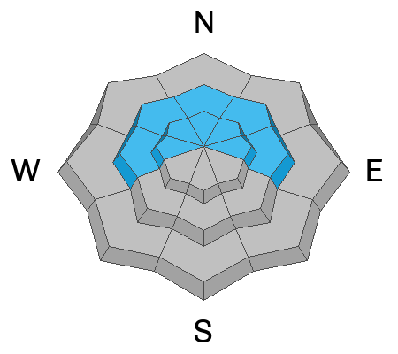
The overall avalanche danger on the Skyline is MODERATE today.

There is a CONSIDERABLE avalanche danger on steep slopes above 8500' that face northwest, north, northeast and east.

Human-triggered avalanches are likely in this terrain.

Low
Moderate
Considerable
High
Extreme
Learn how to read the forecast here
Weather and Snow

General Conditions: Warm weather continues. Temperatures were 40°F or warmer on Friday and only cooled into the low 30s overnight. Wind from the west has slowed in the low and mid elevations but remains a little breezy along the highest terrain. Expect spring-like snow conditions today. The mid elevations will get wet and sloppy as the day goes on.

Mountain Weather: We'll see increasing clouds and temperatures well into the 40s in the higher terrain today. Wind will be from the west in the light to moderate speed ranges. Sunday looks similar with a very minor chance of light precipitation later in the day. We have a couple of chances for snow next week. The first on Monday night and another on Thursday. Neither looks like they'll bring more than a few inches of new snow each.
Avalanche Problem #1
Persistent Weak Layer
Type
Location
Likelihood
Size
Description

Loose sugary facets that formed in January and are now buried caused numerous avalanches over the last week. This is still the main concern, especially above 9500 feet in elevation on northerly-facing slopes. The likelihood of triggering something is slowly decreasing day by day. However, the weak, faceted snow remains buried within the snowpack and is still capable of producing avalanches.

General Announcements
This forecast is from the U.S.D.A. Forest Service, which is solely responsible for its content. This forecast describes general avalanche conditions and local variations always occur.