Forecast for the Skyline Area Mountains

Brett Kobernik
Issued by Brett Kobernik on
Friday morning, February 13, 2026

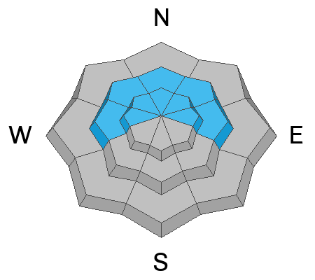
The avalanche danger on the Manti Skyline is MODERATE today. Human-triggered avalanches are possible on the north half of the compass. These will break into weak faceted snow that formed in January. At this time, they will be fairly spotty in distribution and won't be all that large. Collapsing or "whoomping" of the snowpack is a red flag.

Low
Moderate
Considerable
High
Extreme
Learn how to read the forecast here
Weather and Snow

General Conditions: 5 to 8 inches of dense damp snow fell on Wednesday night. A little more snow fell late in the day on Thursday adding another inch or two. Temperatures cooled to around 20°F late in the day so the last little bit of snow should be cold powder. Wind has been very light with this storm from the southwest. The snow was thick on Thursday but did provide some fun turning conditions.

Mountain Weather: Today we'll have mostly cloudy skies and temperatures into the upper 20s. Wind looks like it will be almost calm. We could see a few snowflakes fall but I'm not expecting any real accumulation. Things clear out for the weekend then there are chances for more snow starting early next week.
Avalanche Problem #1
Persistent Weak Layer
Type
Location
Likelihood
Size
Description

It was pretty much inevitable that we were going to have a Persistent Weak Layer avalanche problem after the long dry spell in January. Weak faceted snow formed during that time. It is most pronounced above about 8500' on the north half of the compass. It is now capped off with a thin dense slab of snow which was reactive yesterday. There were no natural avalanches but the snowpack was collapsing during my travels. This indicates all you would need is a steep enough slope to trigger an avalanche. Be sure to CHECK THIS OBSERVATION that I compiled from Thursday for more details on the current situation.

As of now, the new snow slab is fairly thin and collapsing is spotty. The chances of triggering an avalanche are not all that great and they will be fairly small. This could change next week if it snows like weather models are predicting. Bottom line, anticipate things to get dangerous as we add more snow to our weak snowpack.

Here's some more info about our current situation:

General Announcements
This forecast is from the U.S.D.A. Forest Service, which is solely responsible for its content. This forecast describes general avalanche conditions and local variations always occur.