Forecast for the Salt Lake Area Mountains

Drew Hardesty
Issued by Drew Hardesty on
Saturday morning, April 18, 2026

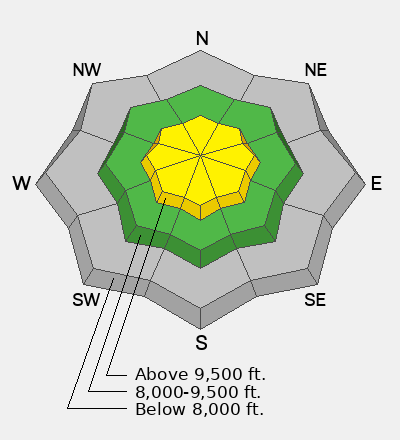
Today you'll find areas of MODERATE avalanche danger in the higher elevation bands.

Here, you will be able to trigger loose dry sluffs and pockets of soft wind slab in steep terrain. With direct sun and daytime warming, you'll increasingly be able to trigger (and observe) wet loose sluffs running far on the slick underlying crusts.

All of these avalanches will be be enough to catch and carry you through the trees or over cliff-bands. Exercise caution in steep terrain today.

Low
Moderate
Considerable
High
Extreme
Learn how to read the forecast here
Special Announcements

Tomorrow will be our last daily morning forecast for the season. We will issue intermittent updates and publish observations through May 1st.

Weather and Snow

Skies are clear. Mountain temperatures are in the teens; winds are generally light (<15mph) from the northwest, but the highest anemometers at 11k registered hourly averages in the 30-35mph range for a few hours last night.

For today - Glorious. Sunny skies, temps warming to the mid-30s up high, the mid-40s down low. Winds trending to light; perhaps even calm.

The Outlook - Benign weather with temperatures dramatically warming over the next several days. The weather models still forecast a cut-off Low pressure system to bob and weave its way through the intermountain west by mid-week.

❄️

It's worth the effort! Those willing to work to get into the high country are finding good riding conditions over an 80-100" base. Thanks to Mark White, Trevor Katz and others for the pics.

Recent Avalanches

All observers out yesterday noted both natural and human triggered loose dry sluffs in the steeper terrain (approaching 40° and steeper) along the higher elevation bands. A few debris piles were probably just enough to bury you, but the main problem would be getting caught and carried into trees or over cliff-bands. (photos: Chamberlain and Katz)

You can view all recent observations HERE.

Avalanche Problem #1
New Snow
Type
Location
Likelihood
Size
Description

In the higher elevation bands, you may be able to trigger shallow pockets of wind blown snow and longer running dry loose sluffs in steep terrain today. I'd expect any avalanche to run fast and far on the underlying slick crusts and entrain enough snow to pack a punch.

Otherwise, your main concerns are with standard springtime mountain hazards:

  • melting creeks and unstable snow bridges
  • melting lakes
  • slide for life
  • failing cornices
  • glide avalanches
  • moats
Avalanche Problem #2
Wet Snow
Type
Location
Likelihood
Size
Description

On steep sunny slopes in the higher elevation bands, you will be able to trigger longer running wet loose sluffs that may run far on the underlying slick crusts. While slow moving, these sluffs will pack a bigger punch than their dry loose cousins on the north side of the compass. Both natural and human triggered wet loose sluffs can be expected today.

Additional Information

We have published February 2026: Four Avalanche Fatalities in Five Days: a community review with most of the UAC Salt Lake office. This 38-minute video is worth sitting down and digesting. A huge thanks to UAC Education Manager & Forecaster McKinley Talty for his hard work putting this together behind the scenes.

General Announcements

This information does not apply to developed ski areas or highways where avalanche control is normally done. This forecast is from the U.S.D.A. Forest Service, which is solely responsible for its content. This forecast describes general avalanche conditions and local variations always occur.