Forecast for the Salt Lake Area Mountains

Bo Torrey
Issued by Bo Torrey on
Friday morning, March 27, 2026

Avalanche danger this morning is LOW and will rise to MODERATE through the day. As daytime temperatures warm and surface crusts soften, it will become possible to trigger wet snow avalanches. Avoid steep slopes with unsupportable snow surfaces during and after the heat of the day.

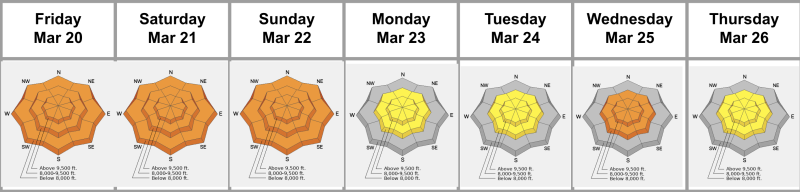
(Gray on the danger rose indicates little to no snow.)

Low
Moderate
Considerable
High
Extreme
Learn how to read the forecast here
Special Announcements

A new version the UAC's mobile app has been released with many new features and performance improvements. Download our app today, available on iPhone and Android. Learn more HERE.

Weather and Snow

Overnight, temperatures dropped below freezing for the first time in 10 days, hitting lows in the upper 20s °F. Skies remained mostly clear until early morning, when incoming clouds caused a slight temperature rebound. At 11,000 feet, north winds blew at 10–20 mph with gusts in the 20s, shifting east by early morning.

Today, skies will be partly sunny with mountain temperatures rising into the 50s °F. Winds continue to veer south and blow 10-25 mph with gusts into the 30s along upper elevation ridges.

Outlook: Stormy weather returns next week, but sadly, models have trended down, and the storm doesn't look as significant as it once did. Stay tuned.

The Week in Review from Friday, March 20 to Thursday, March 26, 2026, was just published and highlights the previous week's key avalanche and weather events contributing to conditions in the backcountry.

Recent Avalanches

No avalanches were reported from the backcountry yesterday. You can view all recent observations HERE.

Avalanche Problem #1
Wet Snow
Type
Location
Likelihood
Size
Description

Overnight, temperatures dropped below-freezing for the first time in 10 days, forming a strong surface crust but not completely stabilizing the warm, unconsolidated snowpack below. The crust will provide a window of safe and supportable travel early today, but once it deteriorates, it will be possible to trigger wet snow avalanches.

  • Wet Loose - This will be the most common concern and the easiest to trigger. As the snow surface becomes soft and slushy, you can trigger wet loose avalanches that start in the surface snow and gouge down into the saturated snowpack. These avalanches start small and can quickly gain volume and speed as they entrain snow.
  • Wet Slabs - As meltwater moves deeper into the snowpack, it can pool on buried crusts or weak layers, weakening the structure and allowing avalanches to break deeper and wider. These are larger and more destructive avalanches and may occur naturally, possibly failing down around crusts that formed over the holidays in late December. The best way to avoid this problem is to avoid travel on and beneath steep slopes during and after the heat of the day when meltwater is moving through the snowpack.
  • Glide Avalanches - These avalanches occur when the entire snowpack slowly slides on the ground, typically over smooth rock slabs or grassy slopes. They are nearly impossible to predict and are almost always natural, such as the avalanche on High Ivory over the weekend. Avoid traveling on or beneath slopes with visible glide cracks or known glide activity, such as Broads Fork, Stairs Gulch, and Mill B South.
General Announcements

This information does not apply to developed ski areas or highways where avalanche control is normally done. This forecast is from the U.S.D.A. Forest Service, which is solely responsible for its content. This forecast describes general avalanche conditions and local variations always occur.