Check out our Holiday Auction - Sign Up for the Utah Snow and Avalanche Workshop (USAW)

Forecast for the Salt Lake Area Mountains

Trent Meisenheimer
Issued by Trent Meisenheimer on
Sunday morning, March 24, 2024
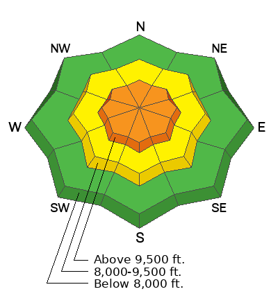
The avalanche danger is CONSIDERABLE across all upper-elevation steep terrain for dry-loose (sluffs) and soft slab avalanches that will fail within the new snow (density changes) or at the old/new snow interface. Strong winds have also created fresh soft slabs of wind-drifted snow. Look for and avoid slopes the wind has loaded.
The wild cards: Thunderstorms and heavy snow showers are forecast today. Remember that even a short period of intense snowfall can instantly spike the avalanche danger. And if, for any reason, we see the sun today, you can guarantee that wet-loose avalanches will happen instantly.
Low
Moderate
Considerable
High
Extreme
Learn how to read the forecast here
Special Announcements
Support the UAC website backend platform to ensure the ongoing security of the website and the data stored on the site rebuild by donating to our spring campaign. Save lives by making a donation today!
Weather and Snow
Welcome back winter. It's snowing, and mountain temperatures range from 15-25 °F. The wind currently blows from the northwest at speeds of 5-15 mph across most upper-elevation terrain. At 11,000' the northwest wind is more robust and blows 20-30 mph with gusts close to 40 mph. Overnight, we picked up 6-14 inches of new snow (0.70-1.22 swe).
Today, we will stay under a cool and moist northwest flow that will bring additional snowfall to the mountains throughout the day. Mountain temperatures will climb into the upper 20s °F. The wind will remain from the northwest and blow 10-20 mph across the upper-elevations. We could see another 3-9 inches of snow throughout the day.
Recent Avalanches
None reported. That will change today.
Ad
Avalanche Problem #1
New Snow
Type
Location
Likelihood
Size
Description
With 6-14 inches of new snow falling overnight, we should all be on guard for how this snow will bond to the underlying surfaces. New snow soft slabs and dry-loose avalanches will be the primary concern today. These avalanches can fail within the new snow (density changes) or at the old/new snow interface. Shovel tilt tests, small test slopes, and slope cuts should be in your arsenal today. Be sure to evaluate the snow stability before committing to any steep terrain.
The wild card: It's spring, and we are under a moist northwest flow; and with daytime heating we could see some intense thunderstorms and heavy snow showers at times. If one of these storms passes over you in the mountains today you will want to be on guard for rapidly changing avalanche conditions. Remember, heavy snowfall (high precipitation intensity) can instantly spike the avalanche danger.
Five years ago today, March 24, 2019, I forecast an overall LOW avalanche danger with 4-6" of new snow overnight. During the day, we saw a quick burst of snowfall followed by many people caught off guard (myself included) and avalanches over a mile-wide. One party triggered an avalanche 12" deep 1000' wide with all six people being caught and carried with two partially buried and one being injured. The question: Is today any different?
Avalanche Problem #2
Wind Drifted Snow
Type
Location
Likelihood
Size
Description
Strong southerly winds ahead of the storm, followed by strong northwest winds during yesterday's frontal passage, makes me think we have some fresh soft slabs of wind-drifted snow. Be on the lookout and avoid snow that looks rounded, wavey, or pillowy. Cracking and collapsing are both signs of unstable snow.
General Announcements
This information does not apply to developed ski areas or highways where avalanche control is normally done. This forecast is from the U.S.D.A. Forest Service, which is solely responsible for its content. This forecast describes general avalanche conditions and local variations always occur.