Forecast for the Provo Area Mountains

Drew Hardesty
Issued by Drew Hardesty on
Tuesday morning, March 24, 2026

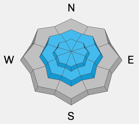
The avalanche danger is MODERATE for both wet-loose and large wet slab avalanches. Avoid being on or underneath steep slopes once the snow surface becomes loose and unconsolidated.

(Gray on the danger rose indicates little to no snow.)

Low
Moderate
Considerable
High
Extreme
Learn how to read the forecast here
Special Announcements

A new version the UAC's mobile app has been released with many new features and performance improvements. Download our app today, available on iPhone and Android. Learn more HERE.

Weather and Snow

Skies are clear, ain't it a shame. In many ways, this winter has been a shame; particularly after the record breaking winter - how snowy it was - in 22/23. Winds are light to moderate from the west; overnight lows are currently in the upper 40s to low 50s.

For today, we'll see mostly sunny skies, light to moderate westerly winds, and temps again reaching to the 50s and 60s. A dry cold front arrives Thursday, but temps rebound once again over the weekend.

Call it mid-March madness, but look at the temperatures at the Timp Divide weather station (8200'). Since Saturday March 14th's cold front, we've had temps more akin to late May and early June.

At that time, there was about 12" of snow-water-equivalent in the snowpack; now there is about half that.

Recent Avalanches

The only avalanche activity reported over the weekend was long-running wet-loose avalanches.

Avalanche Problem #1
Wet Snow
Type
Location
Likelihood
Size
Description

There are two concerns for wet snow avalanches:

1. Wet Loose - This will be the most common concern, with the possibility for natural and human-triggered avalanches involving wet snow near the surface. These may be long-running and gouge down into the snow pack. These avalanches are especially dangerous in steep terrain or above terrain traps such as steep-sided gullies where escaping the flow is difficult.

2. Wet Slabs - As meltwater moves deeper into the snowpack, it can pool on buried crusts or weak layers, weakening the structure and allowing avalanches to break deeper and wider. These are larger and more destructive avalanches and may occur naturally, possibly failing down around crusts that formed over the holidays in late December.

Photo taken by UDOT avalanche forecasters showing recent wet slab activity in the Provo mountains.

General Announcements

This information does not apply to developed ski areas or highways where avalanche control is normally done. This forecast is from the U.S.D.A. Forest Service, which is solely responsible for its content. This forecast describes general avalanche conditions and local variations always occur.