Forecast for the Provo Area Mountains

Greg Gagne
Issued by Greg Gagne on
Monday morning, March 2, 2026

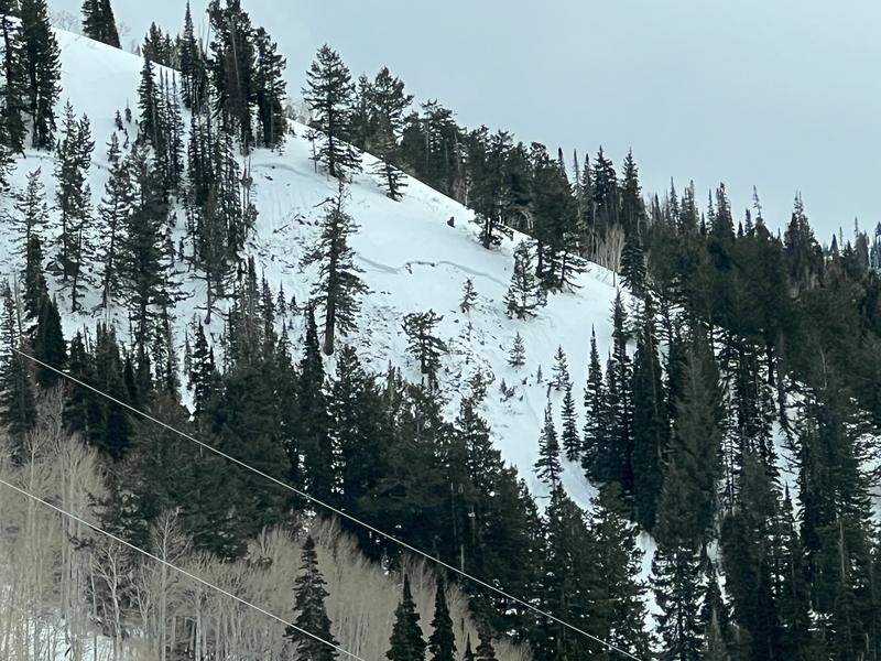
The avalanche danger is CONSIDERABLE on upper-elevation slopes facing northwest, north, and northeast and MODERATE on mid-elevation slopes where it is possible to trigger an avalanche up to three feet deep and over a hundred feet wide, failing on a persistent weak layer.

The danger may rise to MODERATE for wet, loose avalanches on steep, southerly-facing slopes and also during any period of heavy snowfall.

Low
Moderate
Considerable
High
Extreme
Learn how to read the forecast here
Special Announcements

The Butler Basin accident report has been published. Thank you to everyone involved for sharing information. As with all avalanche accidents, we hope to learn something to prevent future accidents. Our deepest heartfelt condolences go out to the family, friends, rescuers, and everyone affected by this tragic accident.

A new blog is posted Riding the Ski Lift With My Daughter. This piece was written to us by longtime friend and backcountry skier John Climaco.

Weather and Snow

This morning: Temperatures are in the 30's °F and winds are from the southwest, gusting in the teens along exposed mid and upper-level ridgelines. Skies are overcast, with some light rain reported overnight.

Today: A chance of snow showers this morning, with snow showers and graupel more likely with the passage of a cold front early this afternoon. Temperatures will rise into the upper 30's and low 40's °F, falling in the afternoon. Winds will be from the southwest, with gusts of 25-30 mph along exposed ridgelines. The rain/snow line will be around 8,500 feet, dropping to 7,000 feet later this afternoon. One to two inches of dense snow is expected by 5 pm.

Overnight: A better chance for snow as the flow switches to the northwest, with up to three inches of snow expected overnight.

Extended: Things will clear out later Tuesday, with sunshine expected for Wednesday. A more promising system on a colder northwest flow is expected for Thursday.

Recent Avalanches

We received no reports from the backcountry in the Provo mountains, but to our north in the Salt Lake mountains, there were reports of both natural and human-triggered wet/loose avalanches.

Though the number of avalanches reported has slowed down, we can't forget that four people have been killed in separate avalanche accidents in the past two weeks.

  • Wednesday 2/18 Ant Knolls, Wasatch Back Fatality — Snowmobiler. Final report HERE.
  • Thursday 2/19 Rock Garden, BCC (Brighton Backcountry) Fatality — 11-year-old skier. Final report HERE.
  • Saturday 2/21 Butler Basin, BCC - Fatality — Backcountry skier. Final report HERE.
  • Sunday 2/22 Caribou Basin, Wasatch Back Fatality — Snowbiker. Preliminary report HERE.

All of these accidents involved slab avalanches 2 to 3 feet thick and up to 500 feet wide, failing on weak faceted snow, our Dry January Layer (DJL).

Avalanche Problem #1
Persistent Weak Layer
Type
Location
Likelihood
Size
Description

I just don't trust this structure. Our Dry January Layer (DJL) of faceted snow is now buried one to three feet deep and is the weak layer for four avalanche fatalities and more than 60 reported avalanches. The slab on top of the DJL has gained strength, and signs of instability - such as collapsing - are no longer common. But an avalanche failing on this layer will be up to three feet deep, and possibly hundreds of feet wide. Spatial variability, rain on snow, and warm temperatures complicate things:

- At upper elevations, you are more likely to trigger an avalanche where the snowpack is thinner. In my field work on Sunday along the Park City Ridgeline, I observed spatial variability where some slopes had a thick, strong slab on top of the DJL, and others where the slab was thinner and I was able to get full propagation with extended column tests. A similar structure exists in the Provo mountains.

- At mid elevations, warm temperatures and rain on snow has further weakened the DJL, and wet slabs failing on moist, weak grains at our DJL are possible, such as a recent avalanche on Brighton Hill in the photo below.

I will continue to avoid steep, northerly-facing slopes, and fortunately, recent dense snow and warm temperatures have smoothed out the snow surface, providing decent travel and riding conditions on slopes less than 30° in steepness.

Avalanche Problem #2
New Snow
Type
Location
Likelihood
Size
Description

Although we are not expecting much snowfall today, periods of heavy snow with some graupel are possible, especially during frontal passage early this afternoon.

Warm temperatures and rain up to 8,500 feet may also induce some wet, loose activity on steep, southerly-facing slopes.

General Announcements

This information does not apply to developed ski areas or highways where avalanche control is normally done. This forecast is from the U.S.D.A. Forest Service, which is solely responsible for its content. This forecast describes general avalanche conditions and local variations always occur.